
Reading is a town in Windsor County, Vermont, United States. The population was 687 at the 2020 census.

A milestone is a numbered marker placed on a route such as a road, railway line, canal or boundary. They can indicate the distance to towns, cities, and other places or landmarks like mileage signs; or they can give their position on the route relative to some datum location. On roads they are typically located at the side or in a median or central reservation. They are alternatively known as mile markers, mileposts or mile posts. A "kilometric point" is a term used in metricated areas, where distances are commonly measured in kilometres instead of miles. "Distance marker" is a generic unit-agnostic term.

A gravestone or tombstone is a marker, usually stone, that is placed over a grave. A marker set at the head of the grave may be called a headstone. An especially old or elaborate stone slab may be called a funeral stele, stela, or slab. The use of such markers is traditional for Chinese, Jewish, Christian, and Islamic burials, as well as other traditions. In East Asia, the tomb's spirit tablet is the focus for ancestral veneration and may be removable for greater protection between rituals. Ancient grave markers typically incorporated funerary art, especially details in stone relief. With greater literacy, more markers began to include inscriptions of the deceased's name, date of birth, and date of death, often along with a personal message or prayer. The presence of a frame for photographs of the deceased is also increasingly common.
A commemorative plaque, or simply plaque, or in other places referred to as a historical marker, historic marker, or historic plaque, is a plate of metal, ceramic, stone, wood, or other material, bearing text or an image in relief, or both, to commemorate one or more persons, an event, a former use of the place, or some other thing. Most such plaques are attached to a wall, stone, or other vertical surface.
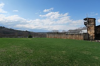
The Fort at Number 4 was a mid-18th century stockade fortification protecting Plantation Number 4, the northernmost British settlement along the Connecticut River in the Province of New Hampshire until after the French and Indian War. It was located in the present-day town of Charlestown, New Hampshire. A recreation of the fort, dating to 1960, now functions as an open-air museum, and was added to the New Hampshire State Register of Historic Places in July 2020.

Salem Street Burying Ground is a cemetery located at the intersection of Salem Street and Riverside Avenue in Medford, Massachusetts. The Salem Street Burying Ground was used exclusively from the late 17th century to the late 19th century for the burial of the town's wealthy. The cemetery was listed on the National Register of Historic Places in 1981.

The Bailey Island Bridge is a historic bridge in the town of Harpswell within Cumberland County in the state of Maine.

Cole's Hill is a National Historic Landmark containing the first cemetery used by the Mayflower Pilgrims in Plymouth, Massachusetts in 1620. The hill is located on Carver Street near the foot of Leyden Street and across the street from Plymouth Rock. Owned since 1820 by the preservationist Pilgrim Society, it is now a public park.
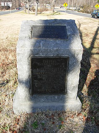
The Brook Road Marker, Jefferson Davis Highway is a commemorative marker on the Jefferson Davis Highway, in Henrico County, Virginia, outside of Richmond, Virginia. The Jefferson Davis Highway was conceived and marked by the United Daughters of the Confederacy, as a counter to the Lincoln Highway in the north, during 1913–1925. In that era, named highways were being marked as automobile travel increased, and the advent of numbered highways eventually loomed. The marker was placed in North Richmond Brook Road, south of Hilliard Road, in 1927. It is one of the earliest, out of 16, that were placed to mark the highway in Virginia by the United Daughters of the Confederacy. It is a 42-inch-high (1.1 m) gray granite stone, with a slanted top, and a bronze plaque.
Susannah Willard Johnson was an Anglo-American woman who was captured with her family during an Abenaki Indian raid on Charlestown, New Hampshire, in August 1754, just after the outbreak of the French and Indian War. Johnson and her family were marched for weeks through the wilderness of New England and Quebec before arriving at the Abenaki village in Saint-François-du-Lac, Quebec. The Johnsons were held for ransom until being sold off into slavery to the French.

The Hammond Covered Bridge is a Town lattice covered bridge spanning Otter Creek in Pittsford, Vermont. The bridge was built in 1842 by Asa Norse, and originally carried Kendall Hill Road, which now passes just to its south. The bridge was added to the National Register of Historic Places on January 21, 1974.

The Old North Cemetery is the oldest cemetery in Truro, Massachusetts. The cemetery, formerly the Old North Graveyard, was established in 1713 on the Hill of Storms where the first church in Truro was built in 1709. It remained the town's only cemetery until 1799 when the Pine Grove Cemetery was established. Old North is on US Route 6 between Aldrich Road and South Highland Road. Many individuals associated with Truro's early development are buried here, as are ship's captains. When originally laid out, the cemetery was about 3 acres (1.2 ha) in size; it was expanded in 1926 and again in 1974 and is now 5.8 acres. The oldest part of the cemetery is its northernmost section, abutting Aldrich Road. As of 2022 there are approximately 1,670 burials in the cemetery. Over half of those buried in the original "Old Stone" (north) section were less than 50 years old when they died.

The Jefferson Davis Highway Marker is a commemorative marker on the Jefferson Davis Highway, in Hanover County, Virginia, near Ashland. It is a 42-inch-high (1.1 m) gray granite stone, with a slanted top, with two bronze plaques. The Jefferson Davis Highway was conceived and marked by the United Daughters of the Confederacy, as a counter to the Lincoln Highway in the north, during 1913–1925. In that era, named highways were being marked as automobile travel increased, and the advent of numbered highways eventually loomed. The marker was placed at the junction of what is now US Route 1 and Cedar Lane, between Richmond and Ashland, in 1927. It has been moved twice: in the 1970s it was moved to accommodate the widening of Route 1, and it was moved across Route 1 in the 1980s.

The Fort Vengeance Monument Site is an archaeological and commemorative site on United States Route 7 in northern Pittsford, Vermont. The site includes the archaeological remains of one of Vermont's oldest documented homesteads, and the only surviving site of a military fortification of the American Revolutionary War. The site is marked by a stone memorial placed in 1873, and was listed on the National Register of Historic Places in 2006.

The Kedron Brook Bridge is a historic stone arch bridge, carrying Densmore Hill Road across Kedron Brook in southern Woodstock, Vermont. Built about 1810, it is one of the state's older stone bridges, built from locally gathered stone. It was listed on the National Register of Historic Places in 1992.

The Beck and Beck Granite Shed is a historic granite shed at 34 Granite Street in the city of Barre, Vermont. Built in 1933, it is a rare surviving example of a rectangular granite shed, a late style of granite processing facility. The Beck and Beck Company was started by the area's first German immigrants, and operated until 1960. The building now houses a non-profit and store that repurposes and recycles building materials. It was listed on the National Register of Historic Places in 2011.

The Vermont Granite Museum is a museum in the city of Barre, Vermont, devoted to the city's historically important granite quarrying and processing industry. It is located at 7 Jones Brothers Way, in the former Jones Brothers Granite Shed, a former granite processing facility listed on the National Register of Historic Places. The Stone Arts School, administered by the museum, is a teaching institution for aspiring sculptors.
The E.L. Smith Roundhouse Granite Shed is a historic granite shed at 23 Burnham Street in the city of Barre, Vermont. Built in 1889, it is the only known surviving example of a circular granite cutting shed in the United States. It was listed on the National Register of Historic Places in 2011.
Carroll City-Mount Olivet Cemetery is a historic site located in Carroll, Iowa, United States. It was listed on the National Register of Historic Places in 2022.


