
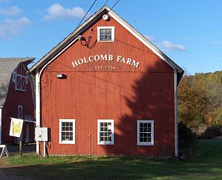
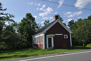
Melrose is a rural village in northeastern East Windsor, Connecticut. Centered at the crossroads of Broad Brook Road and Melrose Road, it was settled in the 1700s and developed as an agrarian village center in the 19th century. A landscape of more than 250 acres (100 ha), including farmland, period farmhouses, ruins of a small distillery, and a district schoolhouse was listed on the National Register of Historic Places in 2010.
Aspetuck is a village, which in Connecticut is an unincorporated community, on the Aspetuck River, in Fairfield County, Connecticut, United States, mostly situated in the town of Easton but extending also into Weston.
The West Granby Historic District is a historic district in Granby, Connecticut, United States. It encompasses the historic village of West Granby, which extends along Simsbury Road between Firetown Road and Hartland Road. Although this area was settled in the 18th century, and has a few surviving buildings from that time, its most significant period of development was in the 19th century, when industry came to play a role in the area. The district was listed on the National Register of Historic Places in 1992.
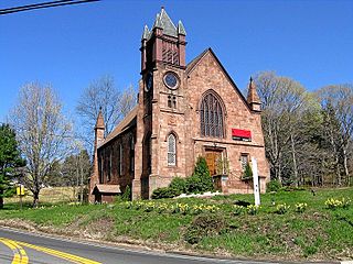
The Northford Center Historic District encompasses the historic village area of Northford in northern North Branford, Connecticut. The basically linear district extends along Middletown Avenue from the village center at its southern end, to a point beyond its northern junction with Old Post Road. The area was settled in the early 18th century, and was transformed into a rural industrial village in the 19th century by the locally prominent Maltby and Fowler families. The district includes many fine pre-Civil-War houses, two churches, and a schoolhouse. It was listed on the National Register of Historic Places in 2002.

The Norwich Village Historic District encompasses the compact village center of Norwich, Vermont. The village was developed mainly in the first half of the 19th century, benefiting in importance from the 1820 founding of what is now Norwich University. The district has well-preserved examples of architecture ranging from the late 18th century to the early 20th century. It was listed on the National Register of Historic Places in 1991.
The Coleman Station Historic District is located around the former New York Central Railroad Coleman's station in the Town of North East, New York, United States, a short distance south of the village of Millerton. It is a rural area including several large farms in the southeastern corner of the town. At almost three square miles (7.33 km2), it is the largest historic district entirely within Dutchess County and the second largest in the county.

The Granby Center Historic District is a predominantly residential historic district encompassing a portion of the village of Granby Center in Granby, Connecticut. The village developed in the 18th century as a farming center, and a now includes a variety of architectural styles from the late 18th to early 20th centuries. The district was listed on the National Register of Historic Places (NRHP) in 1985.

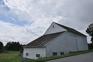
The Spring Hill Historic District encompasses a rural 19th-century village stretching along Storrs Road in Mansfield, Connecticut. Spring Hill developed as a rural waystation on an early 19th-century turnpike, and has seen only modest development since the late 19th century. The district was listed on the National Register of Historic Places in 1979.

The Parker Hill Rural Historic District encompasses a large rural agricultural landscape in eastern Windham and Windsor counties in the US state of Vermont. Roughly centered on Parker Hill Road in northern Rockingham and southern Springfield, the district exhibits a history of 200 years of farming, including a collection of Federal period farm housing. The district was listed on the National Register of Historic Places in 1993.

The Putney Village Historic District encompasses most of the main village and town center of Putney, Vermont. Settled in the 1760s, the village saw its major growth in the late 18th and early 19th century, and includes a cohesive collection with Federal and Greek Revival buildings, with a more modest number of important later additions, including the Italianate town hall. The district was listed on the National Register of Historic Places in 1986.

The East Arlington Village Historic District encompasses the historic core of a 19th-century village in Arlington and Sunderland, Vermont, United States. It is centered on Old Mill Road, and developed as a mill village beginning in the 18th century. It was listed on the National Register of Historic Places in 1996.

The Danby Village Historic District encompasses much of the town center of Danby, Vermont. It is centered on a stretch of Main Street, roughly between Depot Street and Brook Road. The village has a cohesive collection of mid-19th century architecture, mostly residential, with a modest number of later additions. The district was listed on the National Register of Historic Places in 1983.
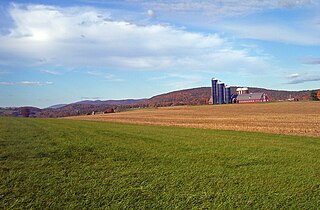
The Jericho Rural Historic District encompasses a rural agricultural landscape of northern Hartford, Vermont, extending slightly into neighboring Norwich. The area covers 774 acres (313 ha) of mainly agricultural and formerly agricultural lands, as well as associated woodlots, and includes nine historically significant farm complexes. It was listed on the National Register of Historic Places in 2001.
The Witherill Farm is a historic farm property on Witherill Road in Shoreham, Vermont. With a history dating to the late 18th century, the farm was for two centuries managed by generations of the same family, and was a noted early exporter of merino sheep to South Africa. Most of the farmstead buildings were built before 1850. The property was listed on the National Register of Historic Places in 1993.

The Guildhall Village Historic District encompasses the central common and surrounding buildings in the village center of Guildhall, Vermont. The town, the first to be settled in Vermont's Northeast Kingdom, has a history from the late 18th century as a commercial, civic, and industrial center, and is the shire town of Essex County. The district was listed on the National Register of Historic Places in 1980.

The Hunt Hill Farm is a historic farm property at Upland and Crossman Roads in New Milford, Connecticut. Also known as the Hine–Buckingham Farms, the 137-acre (55 ha) property encompasses two farm properties that remained family-run from the 18th to early 20th centuries. The property includes one 18th and several 19th-century farmhouses and other outbuildings. It was listed on the National Register of Historic Places in 2004. The farmstead is now home to The Silo at Hunt Hill Farm, an arts and culinary organization, while much of the land is held as conservation land by the town.
The Maple Hill Farm is a historic farm property at 65 Maple Hill Road in Norwich, Vermont. Encompassing more than 40 acres (16 ha) of woodlands and pasture, the farm has more than 200 years of architectural history, including a late 18th-century farmhouse built by Peter Olcott, and two barns from that period. It remained an active farm property until 1966. The property was listed on the National Register of Historic Places in 2020.
The Meeting House Farm is a historic farm property at 128 Union Village Road in Norwich, Vermont. Encompassing more than 90 acres (36 ha) of woodlands and pasture, the farm has more than 200 years of architectural history, including a late 18th-century farmhouse and an early 19th-century barn. The property was listed on the National Register of Historic Places in 2020.
The Brigham Hill Historic District encompasses a rural 19th-century landscape in central Norwich, Vermont. It includes three late 18th or early 19th century farmsteads, all associated with the Brigham family, whose progenitor, Paul Brigham, was prominent in Vermont politics. It was listed on the National Register of Historic Places in 2020.
The Luce Farm is a historic farm property at 170 Luce Drive in Stockbridge, Vermont. The farm was established in the late 18th century, and is a well-preserved example of a rural agriculturally diversified farm property. It was listed on the National Register of Historic Places in 2021.


