
The Appalachian Mountains, often called the Appalachians, are a system of mountains in eastern North America. The Appalachians first formed roughly 480 million years ago during the Ordovician Period. They once reached elevations similar to those of the Alps and the Rocky Mountains before experiencing natural erosion. The Appalachian chain is a barrier to east–west travel, as it forms a series of alternating ridgelines and valleys oriented in opposition to most highways and railroads running east–west.

Thousand Oaks is the second-largest city in Ventura County, California, United States. It is in the northwestern part of Greater Los Angeles, approximately 40 miles (64 km) from Downtown Los Angeles and is less than 15 miles (24 km) from the Los Angeles neighborhood of Woodland Hills. It is named after the many oak trees present in the area, and the city seal is adorned with an oak.

The Ozark – St. Francis National Forest is a United States National Forest that is located in the state of Arkansas. It is composed of two separate forests, Ozark National Forest in the Ozark Mountains; and St. Francis National Forest on Crowley's Ridge. Each forest has distinct biological, topographical, and geological differences.

The Ramapo Mountains are a forested chain of the Appalachian Mountains in northeastern New Jersey and southeastern New York, in the United States. They range in height from 900 to 1,200 feet in New Jersey, and 900 to 1,400 feet in New York.

The Blue Ridge Mountains are a physiographic province of the larger Appalachian Mountains range. The mountain range is located in the eastern United States, and extends 550 miles southwest from southern Pennsylvania through Maryland, West Virginia, Virginia, North Carolina, South Carolina, Tennessee and Georgia. This province consists of northern and southern physiographic regions, which divide near the Roanoke River gap. To the west of the Blue Ridge, between it and the bulk of the Appalachians, lies the Great Appalachian Valley, bordered on the west by the Ridge and Valley province of the Appalachian range.

The Conejo Valley is a region spanning both southeastern Ventura County and northwestern Los Angeles County in Southern California, United States. It is located in the northwestern part of the Greater Los Angeles Area.

Wawayanda State Park is a 34,350 acres (139.0 km2) state park in Sussex County and Passaic County in northern New Jersey. The park is in Vernon Township on the Sussex side, and West Milford on the Passaic side. There are 60 miles (97 km) of hiking trails in the park, including a 20 miles (32 km) stretch of the Appalachian Trail. The park is operated and maintained by the New Jersey Division of Parks and Forestry. The hiking trails are maintained and updated by the New York - New Jersey Trail Conference.

Oak Mountain State Park is a publicly owned recreation area located approximately 20 miles (32 km) south of Birmingham in the northeast quadrant of the city of Pelham, Alabama, United States. It is the state's largest state park at 9,940 acres (4,020 ha) and is home to the Alabama Wildlife Center, Oak Mountain Interpretive Center, and Oak Mountain BMX Track. Park activities include hiking, swimming, camping, fishing, horseback riding, and golf. The park is managed by the Alabama Department of Conservation and Natural Resources.
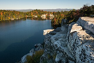
The Minnewaska State Park Preserve is a 22,275-acre (90.14 km2) preserve located on the Shawangunk Ridge in Ulster County, New York on US 44/NY 55, five miles (8.0 km) west of New York State Route 299. The park, which features scenic overlooks of the nearby Catskill Mountains, is primarily used for picnicking, hiking, mountain biking, snowshoeing and swimming. The park is managed by the Palisades Interstate Park Commission and the New York State Office of Parks, Recreation and Historic Preservation.

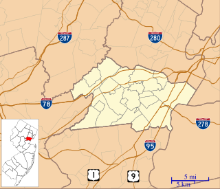
Kittatinny Mountain is a long ridge traversing across northwestern New Jersey running in a northeast-southwest axis, a continuation across the Delaware Water Gap of Pennsylvania's Blue Mountain Ridge. It is the first major ridge in the far northeastern extension of the Ridge and Valley province of the Appalachian Mountains, and reaches its highest elevation, 1,803 feet, at High Point in Montague Township. Kittatinny Mountain forms the eastern side of Wallpack Valley; the western side comprises the Wallpack Ridge (highest elevation: 928 feet above sea level.

Tizi Ouzou or Thizi Wezzu is a city in north central Algeria. It is among the largest cities in Algeria and is the capital and largest city of Tizi Ouzou Province. It is the second most populous city in the Kabylie region behind Béjaïa.
Oak Knoll School of the Holy Child is a Catholic private school in Summit, in Union County, New Jersey, United States. It is coeducational from kindergarten to grade 6 and all-girls for seventh grade to twelfth grade. The school operates under the supervision of the Roman Catholic Archdiocese of Newark. The school is accredited by the Middle States Association of Colleges and Schools Commission on Secondary Schools since 1992. The school is a member of the New Jersey Association of Independent Schools.
Oak Mountain may refer to:

Mount Everett at 2,608 ft - or 793.1 m - is the highest peak in the south Taconic Mountains of Massachusetts, Connecticut and New York. The mountain is known for its expansive views of the southern Taconics and Berkshires; for its old growth pitch pine and scrub oak; for the Appalachian Trail's north-south traverse of its shoulders and summit grounds, and for its rare plant and animal communities. The mountain is named after a 19th-century governor of Massachusetts, Edward Everett. The name was proposed in 1841 by Edward Hitchcock, geologist to the state, in his "Final Report on the Geology of Massachusetts." Hitchcock wrote that at the time of his proposal, the mountain was known as Bald Mountain or Ball Mountain. Some old maps at the Sheffield Historical Society also label the mountain as "The Dome".

Alander Mountain, 2,239 feet (682 m), is a prominent peak of the south Taconic Mountains; it is located in southwest Massachusetts and adjacent New York. Part of the summit is grassy and open and part is covered with scrub oak and shrubs; the sides of the mountain are wooded with northern hardwood tree species. Views from the top include the southern Taconic Mountains, the Hudson River Valley including the Catskills. Several trails traverse Alander Mountain, most notably the 15.7 mi (25.3 km) South Taconic Trail, which passes just beneath the summit.
Mount Fray, 1,893 feet (577 m), also known as Catamount because of the Catamount Ski Area located on its north slope, is a prominent peak of the south Taconic Mountains, located in southwest Massachusetts and adjacent New York. The summit is open and covered in scrub oak; it offers views west over the Hudson River Valley. The sides of the mountain are wooded with northern hardwood tree species. The 15.7 mi (25.3 km) South Taconic Trail passes over the summit of Mount Fray.

Mount Race, 2,365 feet (721 m), is a prominent peak in the south Taconic Mountains of Massachusetts. The mountain is known for its waterfalls, steep, eastern ridgeline cliff face and expansive views of the Housatonic River valley and Berkshires to the east and of fellow Taconics to the south, west and north and Catskills and Hudson River valley to the west, for the traverse of the said cliffline and the summit grounds by the Appalachian Trail and for its old growth pitch pine and scrub oak summit ecosystem.

Oaks Creek is a river that drains Canadarago Lake, which is situated in the north central region of Otsego County, New York. The creek begins by the hamlet of Schuyler Lake and flows southeast approximately 9.32 miles before converging with the Susquehanna River south of Cooperstown, by Index. From the source to Oaksville the creek flows along Panther Mountain. Fly Creek is a main tributary, that converges with Oaks Creek south of the hamlet of Fly Creek.

Panther Mountain is a mountain located in Central New York of New York near Fly Creek, New York and Schuyler Lake, New York. The east side of Panther Mountain drains into Fly Creek and the west side drains into Oaks Creek and Canadarago Lake.
Oak Hill is a mountain located in the Catskill Mountains of New York east of Franklin. Jackson Hill is located northeast, Roundtop is located west, and Heathen Hill is located south-southwest of Oak Hill.


