
Oakland is the academic and healthcare center of Pittsburgh and one of the city's major cultural centers. The neighborhood is home to three universities, museums, and hospitals, as well as an abundance of shopping, restaurants, and recreational activities. Oakland is home to the Schenley Farms National Historic District which encompasses two city designated historic districts: the mostly residential Schenley Farms Historic District and the predominantly institutional Oakland Civic Center Historic District. It is also home to the locally designated Oakland Square Historic District. The Pittsburgh Bureau of Fire has Fire Station No. 14 on McKee Place and Fire Station No. 10 on Allequippa Street in Oakland.
Clintonville is a neighborhood in north-central Columbus, Ohio, United States with around 30,000 residents. Clintonville is an informal neighborhood. The southern border is loosely defined as the center of the Glen Echo Ravine. To the east, either Interstate 71 or the adjacent railroad tracks are commonly accepted. The western boundary is the Olentangy River. The northern border of Clintonville is the most ambiguous, with definitions anywhere in the 3 mi (4.8 km) stretch from Cooke Road to the southern border of Worthington. The Clintonville Area Commission boundaries, as established by Columbus City Code, are "bounded on the south by the centerline of the Glen Echo Ravine; on the east by the centerline of the railroad right-of-way immediately east of Indianola Avenue; on the north by the Worthington city limits and on the west by the Olentangy River; each line extended as necessary so as to intersect with adjacent boundaries".

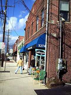
Victorian Village is a neighborhood in Columbus, Ohio, United States, north and near west of downtown. It is an established neighborhood built when a streetcar line first ran along Neil Avenue around 1900 with a fair number of established trees for an urban setting. To preserve, protect and enhance the unique architectural and historical features, the Victorian Village Historic District was established in 1973. Columbus Monthly named this neighborhood the top place to live for Arts and Entertainment, with fun right around the corner in the Short North as its neighborhood hangout.
Franklinton is a neighborhood in Columbus, Ohio. Franklinton is the first American settlement in Franklin County, Ohio. As the city of Columbus grew, the city annexed and incorporated the existing settlement and today it exists as a neighborhood immediately west of downtown, including the Scioto Peninsula.
The University District, is a 2.8-square-mile (7.3 km2) area located 2 miles (3.2 km) north of Downtown Columbus, Ohio that is home to the main campus of The Ohio State University, the Battelle Institute, and the Arthur G. James Cancer Hospital and Richard J. Solove Research Institute. It is generally accepted as the area bounded to the north by Clintonville at Glen Echo Ravine; to the south by the Short North at 5th Avenue; to the west by the Olentangy River and to east by the ConRail railroad tracks. Points of interest include, but are not limited to, the Ohio Stadium and Old North Columbus; The district is Columbus' most densely populated area and contains more than 650 businesses, human service agencies, churches, and schools. University District businesses include boutiques, mixed retail, several tattoo studios, the Landmark Gateway theater, and a diverse range of restaurants and bars.

According to the U.S. Census Bureau, the Columbus, OH Metropolitan Statistical Area is the metropolitan area centered on the U.S. city of Columbus, Ohio. It includes the counties of Delaware, Fairfield, Franklin, Hocking, Licking, Madison, Morrow, Perry, Pickaway, and Union. The population of the MSA is 2,078,725 according to 2017 census estimates, making the Columbus metropolitan area the 32nd most populous in the United States and the second largest in Ohio behind the Cincinnati Metropolitan Statistical Area.

Lewis Center is an unincorporated community in northwestern Orange Township, Delaware County, Ohio, United States, in the Columbus, OH Metropolitan Statistical Area.
The Near East Side is a neighborhood located near downtown Columbus, Ohio, made up of several neighborhoods: Beatty Park, King-Lincoln (Bronzeville), Eastgate, Franklin Park, Nelson Park, Olde Towne East, and Woodland Park.
Murray Hill is a street in a neighborhood on the westside of Columbus, Ohio. It is part of the Lincoln Village subdivision and is colloquially known as Lincoln Village. It is bounded by West Broad Street on the north, Sullivant Avenue on the south, South Grener Avenue on the east, and Redmond and Hiler Roads on the west. It is in Prairie Township, and the ZIP Code 43228.

Downtown Columbus is the central business district of Columbus. Downtown is centered on the intersection of Broad and High Streets, and encompasses all of the area inside the Inner Belt. Downtown is home to most of the tallest buildings in Columbus.
The Brewery District, traditionally known as the Old German Brewing District, is a neighborhood located in Columbus, Ohio, USA. Located just south of the central business district and west of German Village, it is bounded by Interstate 70 on the north, South Pearl Street on the east, Greenlawn Avenue on the south, and the Scioto River on the west.
Columbus, Ohio has numerous neighborhoods within the city limits.

Harrison West is an historic, urban neighborhood located northwest of downtown Columbus, Ohio. It sits on several-blocks along the Olentangy River, and is the western part of the Near Northside Historic District. It was placed on the National Register of Historic Places in 1975. The character of the neighborhood is similar to Victorian Village, which sits just to the east and is a little more well-known.
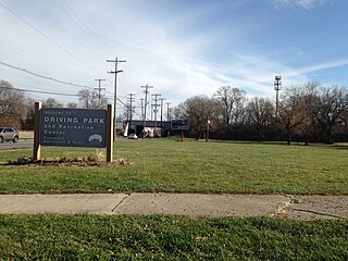
Driving Park is an urban residential area on the Near East Side of Columbus, Ohio just south of Interstate 70. Mainly a middle-class, predominantly African American neighborhood, Driving Park and its surrounding neighborhoods consist of an area of 17,730 residents. Driving Park received its name from its historic past as a large racing complex, first for horses and later for automobiles.

Old North Columbus is a neighborhood located just north of the Ohio State University in Columbus, Ohio. It was founded in 1847 where, at the time, it was a stand-alone city out of the confines of Columbus until it was incorporated into the City of Columbus in 1871. In its early years the city was a popular stagecoach stop with people traveling from Worthington to Columbus. Today Old North Columbus is popular for its local music and its unique "untouched architecture" which is reminiscent of its old roots.
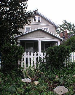
Glen Echo is a neighborhood located in the far northern part of the University District in Columbus, Ohio. The area was listed on the National Register of Historic Places in 1997. The name Glen Echo refers to Glen Echo Ravine, which runs along the northern edge of the neighborhood. Principal streets in the area are Glen Echo Drive, Summit Street, Glenmawr Avenue, North Fourth Street, Arcadia, Cliffside Drive, and more. One street, Parkview Drive, was platted in the ravine basin, but was later abandoned.
The city of Columbus is located in central Ohio at the confluence of the Scioto and Olentangy rivers. The region is dominated by a humid continental climate, characterized by hot, muggy summers and cold, dry winters.
The community of Forest Park consists of almost 2900 private residential properties, plus apartments, condominiums, commercial properties, city-owned parks and schools, in approximately 1.4 square miles (3.6 km2) of the Northland area of northeast Columbus, Ohio. These properties adjoin a total of 132 distinct streets and courts maintained by the City of Columbus. The community's approximate center is near the intersection of Karl Road and Sandalwood Place in Columbus.
Flytown is a neighborhood just northwest of downtown Columbus encompassing portions of the present-day Arena District and western sections of the Victorian Village. In the 19th century, it was considered the center of the Irish-American community in the city after the arrival of immigrants fleeing the Great Famine, and Naghten Street, now Nationwide Boulevard, was nicknamed the "Irish Broadway".
Briggsdale is a neighborhood of Franklin County in the city of Columbus, Ohio. The neighborhood is on the west/southwest side of the city within the Hilltop area. The area was first settled and founded by the family of Joseph M. Briggs, after whom the neighborhood was named. Joseph Briggs was an active figure in the early years of the township and county operations. The Briggsdale Methodist church was founded with his help, and it now exists as the New Horizons Methodist Church. The present day Briggsdale neighborhood is located near the historical Green Lawn Cemetery to the north as well as Briggs High School to the west.


