
Bangor is a city in and the county seat of Penobscot County, Maine, United States. The city proper has a population of 31,753, making it the state's third-most populous city, behind Portland (68,408) and Lewiston (37,121). Bangor is known as the "Queen City."

Orono is a town in Penobscot County, Maine, United States. Located on the Penobscot and Stillwater rivers, it was first settled by American colonists in 1774. They named it in honor of Chief Joseph Orono, a sachem of the indigenous Penobscot nation who long occupied this territory.
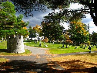
Mount Hope Cemetery in Bangor, Maine, is the second oldest garden cemetery in the United States. It was designed by architect Charles G. Bryant in 1834 and built by the Bangor Horticultural Society soon after, the same year that Bangor was incorporated as a city. The cemetery was modeled after Mount Auburn Cemetery (1831) in Boston, Massachusetts. Bangor was at that time a frontier boom-town, and much of its architecture and landscaping was modeled after that of Boston. The site has been listed on the National Register of Historic Places.
The Broadway Historic District in Bangor, Maine, United States, bounded by Garland, Essex, State, Park, and Center Streets, is one of the residential neighborhoods most favored by the city's lumber barons and business elites in the early to late 19th century. A second and slightly later Bangor neighborhood of primarily elite houses, centered on West Broadway, is also listed on the National Register of Historic Places as the Whitney Park Historic District. Both historic districts are also protected under local ordinance.

The Saco Historic District encompasses the historic commercial and residential centers of Saco, Maine. Covering more than 100 acres (40 ha) of central Saco, it includes houses from the 18th through 20th centuries, and the main business district along Main Street. It was added to the National Register of Historic Places in 1998.
Wilfred E. Mansur (1855–1921) was the most prominent architect in late 19th and early 20th century Bangor, Maine.

The Page Farm & Home Museum is a museum on the campus of the University of Maine in Orono, Maine. Its mission is "to collect, document, preserve, interpret and disseminate knowledge of Maine history relating to farms and farming communities between 1865 and 1940, providing an educational and cultural experience for the public and a resource for researchers of this period." The University of Maine was founded in 1865 as the "Maine College of Agriculture and the Mechanic Arts". The centerpiece of the museum is the Maine Experiment Station Barn, a 19th-century barn, listed on the National Register of Historic Places, that is the last standing agricultural building on the campus.
The Main Street Historic District of Fryeburg, Maine, encompasses the growth of the town's principal village between about 1800 and 1935. It extends along Main Street, from Woodland Street in the north to Portland Street (SR 5 and Maine State Route 113) in the south, and includes forty primary buildings on 55 acres (22 ha). The district was listed on the National Register of Historic Places in 1991.

The Norway Historic District encompasses most of the historic village center of Norway, Maine, and is reflective of the town's growth over 150 years. Although significant early-to-mid 19th century buildings survive in the village, it was significantly damaged by a major fire in 1894, resulting in the construction of a number of new brick and wood-frame buildings. The district, which is 44 acres (18 ha) in size, includes 64 historically significant residential, civic, social, and commercial buildings, and was listed on the National Register of Historic Places in 1988.

The Whitney Park Historic District is a residential historic district on the west side of Bangor, Maine. The district contains 42 residential properties built between 1850 and 1910, a major period of the city's growth, and is anchored on its south by Whitney Park, a small triangular park at Hammond and Cedar Streets. The district was listed on the National Register of Historic Places in 1988, and is protected by the city's local historic district ordinance.
The Gov. Israel Washburn House is a historic house at 120 Main Street in Orono, Maine. Built in 1840, it is architecturally significant as a fine local example of Greek Revival architecture, and is historically significant as the long-time home of Governor of Maine Israel Washburn, Jr. It was listed on the National Register of Historic Places in 1973.

The Nathaniel Treat House is a historic house at 114 Main Street in Orono, Maine. Probably built in the 1830s, the house is a fine example of transitional Federal-Greek Revival architecture executed in brick. The house was built by Nathaniel Treat, and was in the 20th century home to Charles J. Dunn, chief justice of the Maine Supreme Judicial Court. The house was listed on the National Register of Historic Places in 1973.

The Sargent-Roberts House is a historic house at 178 State Street in Bangor, Maine. Built in 1814 and restyled several times, the house exemplifies a local trend to update high-quality houses to the latest styles in 19th-century Bangor. The house's exterior is a Second Empire alteration of a Federal period structure, with an interior exhibiting Federal and Greek Revival features. It was listed on the National Register of Historic Places in 1996.
The Calais Residential Historic District encompasses the town's best collection of well-preserved 19th-century residences in Calais, Maine. Located on Calais Avenue and Main Street, the district includes twenty properties developed between the early 19th century and 1900. It was listed on the National Register of Historic Places in 1994.
The Belfast Historic District encompasses a large portion of the city center of Belfast, Maine, representing one of Maine's largest concentrations of pre-Civil War architecture, as well as a rich collection of commercial architecture of the late 19th and early 20th centuries. The district was listed on the National Register of Historic Places in 1986, with minor enlargements in 1993 and 1995.
The Dennysville Historic District encompasses the historic town center of Dennysville, Maine. Located near the southern end of the large rural community, its architecture covers more than 100 years of community history, from the early 19th to early 20th centuries. The district extends along Main Street between Maine State Route 86 and Bunker Hill Road, on the west bank of the Dennys River. It was listed on the National Register of Historic Places in 1982.

The Church Street Historic District is a predominantly residential historic district in Belfast, Maine. The 30-acre (12 ha) district extends along Church Street roughly between Franklin and High Streets, and encompasses a neighborhood of homes dating from the early 19th to the early 20th century, the major period of the city's growth. The district was listed on the National Register of Historic Places in 1978, and is contained within the larger Belfast Historic District.

The Winterport Historic District encompasses a significant portion of the town centre of Winterport, Maine. The town was mainly developed in the mid-19th century, when it served as the main winter port for Bangor, and features a high concentration of Greek Revival and Italianate architecture. It was listed on the National Register of Historic Places in 1975.

The Thomaston Historic District encompasses much of the historic town center of Thomaston, Maine. With a settlement history dating to the 17th century, the town is now a showcase of 19th-century architectural styles up to the 1870s. The district extends for about 2 miles (3.2 km) along United States Route 1, and was listed on the National Register of Historic Places in 1974.

The Main Street–College Street Historic District encompasses a historically fashionable residential area of Burlington, Vermont. Principally located along Main and College Streets between South Winooski and South Williams Streets, the area was one of the city's most exclusive residential areas from the early 19th century to the early 20th century, and includes a diversity of high quality architecture from that period. It was listed on the National Register of Historic Places in 1988.

