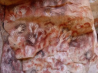
In archaeology, cave paintings are a type of parietal art, found on the wall or ceilings of caves. The term usually implies prehistoric origin, and the oldest known are more than 40,000 years old and found in the caves in the district of Maros. The oldest are often constructed from hand stencils and simple geometric shapes. More recently, in 2021, cave art of a pig found in Sulawesi, Indonesia, and dated to over 45,500 years ago, has been reported.

Newspaper Rock State Historic Monument is a Utah state monument featuring a rock panel carved with one of the largest known collections of petroglyphs. It is located in San Juan County, along Utah State Route 211, 28 miles (45 km) northwest of Monticello and 53 miles (85 km) south of Moab.

A petroglyph is an image created by removing part of a rock surface by incising, picking, carving, or abrading, as a form of rock art. Outside North America, scholars often use terms such as "carving", "engraving", or other descriptions of the technique to refer to such images. Petroglyphs, estimated to be 20,000 years old are classified as protected monuments and have been added to the tentative list of UNESCO's World Heritage Sites. Petroglyphs are found worldwide, and are often associated with prehistoric peoples. The word comes from the Greek prefix petro-, from πέτρα petra meaning "stone", and γλύφω glýphō meaning "carve", and was originally coined in French as pétroglyphe.

In archaeology, rock art is human-made markings placed on natural surfaces, typically vertical stone surfaces. A high proportion of surviving historic and prehistoric rock art is found in caves or partly enclosed rock shelters; this type also may be called cave art or parietal art. A global phenomenon, rock art is found in many culturally diverse regions of the world. It has been produced in many contexts throughout human history. In terms of technique, the four main groups are:
Bell Coulee Shelter is a prehistoric rock shelter for ancient people, located in Mindoro, Wisconsin, in La Crosse County, Wisconsin.

Coso Rock Art District is a rock art site containing over 100,000 Petroglyphs by Paleo-Indians and/or Native Americans. The district is located near the towns of China Lake and Ridgecrest, California. Big and Little Petroglyph Canyons were declared a National Historic Landmark in 1964. In 2001, they were incorporated into this larger National Historic Landmark District. There are several other distinct canyons in the Coso Rock Art District besides the Big and Little Petroglyph Canyons. Also known as Little Petroglyph Canyon and Sand Tanks, Renegade Canyon is but one of several major canyons in the Coso Range, each hosting thousands of petroglyphs. The majority of the Coso Range images fall into one of six categories: bighorn sheep, entopic images, anthropomorphic or human-like figures, other animals, weapons & tools, and "medicine bag" images. Scholars have proposed a few potential interpretations of this rock art. The most prevalent of these interpretations is that they could have been used for rituals associated with hunting.

Chumash rock art is a genre of paintings on caves, mountains, cliffs, or other living rock surfaces, created by the Chumash people of Southern California. Pictographs and petroglyphs are common through interior California, the rock painting tradition thrived until the 19th century. Chumash rock art is considered to be some of the most elaborate and plentiful rock art tradition in the region.

The Burro Flats site is a painted cave site located near Burro Flats, in the Simi Hills of eastern Ventura County, California, United States. The Chumash-style "main panel" and the surrounding 25-acres were listed on the National Register of Historic Places in 1976, with a boundary decrease in 2020. The main panel includes dozens of pictographs in a variety of colors. The cave is in the mountains, near the bi-lingual Chumash/Fernandeno village of Huwam/Jucjauynga. The Burro Flats painted cave and the rest of the former Santa Susana Field Laboratory are not accessible to the public.
American Indian Rock Art in Minnesota MPS is a Multiple Property Submission (MPS) of the eligibility of many rock art properties for listing on the National Register of Historic Places. The listing is to protect and preserve Native American petroglyphs, pictographs and petroform rock art sites in the present day U.S. state of Minnesota.
Aboriginal sites of New South Wales consist of a large number of places in the Australian state of New South Wales where it is still possible to see visible signs of the activities and culture of the Australian Aboriginals who previously occupied these areas.

Cañon Pintado, meaning painted canyon, is an archaeological site of Native American rock art located in the East Four Mile Draw, 10.5 miles (16.9 km) south of Rangely in Rio Blanco County, Colorado. Led by Ute guides, the Domínguez–Escalante expedition, Spanish missionaries in search of a route to California in 1776, passed through this region as they moved north and then west into Utah. The first Europeans to the area, they named it Cañon Pintado, meaning "painted canyon".
Archeological Site CA-INY-134, in Inyo County, California near Olancha, California, is an archeological site that is listed on the National Register of Historic Places (NRHP). The site is located in the Coso Range 6 miles (9.7 km) northwest of Coso Hot Springs. It has also been known as Ayer's Rock Pictograph Site, as Bob Rabbit's Pictographs, as INY-134 and as INY-105. Prehistorically, it served as a camp and as a ceremonial site. The site includes three pictograph panels carved into a monolith. The pictographs are painted in a variety of colors and depict animal and human figures.

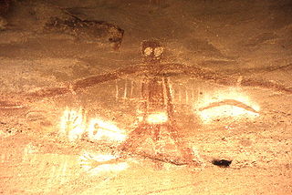
The Piney Creek Site is a prehistoric rock art site located on the north side of Piney Creek in Piney Creek Ravine State Natural Area in Randolph County, Illinois. The site consists of a sandstone outcropping with over 150 petroglyph and pictograph designs, the most at a single known site in Illinois. The designs are divided into four distinct groups; three of these are on the center and ends of the rock shelter's wall, while the fourth is on a joint block of sandstone within the shelter. Most of the designs were created during the Late Woodland and Mississippian periods, which spanned from 450 to 1550 A.D.; a number of the figures were added after 1550. A 1 metre tall spear-holding anthropomorph in the western group is the largest individual petroglyph in Illinois. In addition to anthropomorphs, other common designs at the site include zoomorphs, quadrupeds which probably represent deer, and symbols; the quadrupeds and anthropomorphs are frequently depicted in motion. The rock shelter was likely used as a religious site by prehistoric inhabitants, and several of the designs appear to have mystical or spiritual significance; for instance, the winged anthropomorphs likely represent shamans.

The Piney Creek South Site is a prehistoric rock art site located on the south side of Piney Creek in Piney Creek Ravine State Natural Area in Randolph County, Illinois. The site consists of two groups of petroglyphs drawn on a sandstone rockshelter. The petroglyphs most likely date from the Late Woodland period, which lasted from 450 to 900 A.D. The larger petroglyph group contains ten designs: four anthropomorphs, a quadruped resembling a deer, three crosses, and two pits. The four designs in the smaller group include two anthropomorphs, a group of pits extending from an anthropomorph's head, and a pecked area. Several of the anthropomorphs appear to have wings, two are carrying shields or rattles, one appears to have a beak, and one may have a crude penis. The site likely had spiritual significance, and the anthropomorphs may represent shamans, who were frequently depicted with wings in Native American art.

The Tegtmeyer Site is a prehistoric rock art site located north of Piney Creek in Piney Creek Ravine State Natural Area in Randolph County, Illinois. The site consists of two petroglyphs painted on a sandstone rock shelter. One petroglyph depicts a winged anthropomorph in flight, while the other depicts a winged zoomorph which may also be flying. Based on their similarity to other sites from the period, the petroglyphs at the site most likely date from the Mississippian period. The petroglyphs resemble some of the figures painted at the nearby Piney Creek Site; given that the Tegtmeyer Site was unsuitable for inhabitation, it was most likely used for additional paintings which could not fit at the Piney Creek Site.
The Fox Pictograph is a prehistoric rock art site in Stone County, Arkansas. Located near the community of Fox, it is one of two documented examples of rock art depicting humans in the state. It is a stick figure, painted in red pigment, with an unusual depiction of ear ornaments. The figure is about 127 centimetres (50 in) in height.

Petit Jean State Park is the oldest state park in Arkansas. It is located in the central northern part of the state, in western Conway County, atop Petit Jean Mountain, a ridge between the Ozark and Ouachita Mountains. One of the features the park is noted for is prehistoric rock art, some of which is accessible to park visitors via its hiking trails. A total of twelve such sites have been listed on the National Register of Historic Places for their importance. Most of the rock art has been dated to about 1500 CE, and is not obviously associated with habitation sites or other sites bearing evidence of other Native American activities.

The Ambadevi rock shelters are part of an extensive cave site, where the oldest yet known traces of human life in the central province of the Indian subcontinent were discovered. The site is located in the Satpura Range of the Gawilgarh Hills in Betul District of the Indian state of Madhya Pradesh, north of Dharul village in Amravati district of Maharashtra. Studies of various rock paintings and petroglyphs present in the caves suggest, that the Ambadevi rock shelters were inhabited by prehistoric human settlers since around 25,000 years ago. First discoveries of clusters of numerous rock shelters and caves were made by Vijay Ingole and his team beginning on 27 January 2007. Named after the nearby ancient Ambadevi Cave Temple, the site has also been referred to as the Satpura-Tapti valley caves and the Gavilgarh-Betul rock shelters. The Ambadevi rock shelters rank among the most important archaeological discoveries of the early 21st Century in India, on par with the 20th Century discovery of the Bhimbetka rock shelters.


