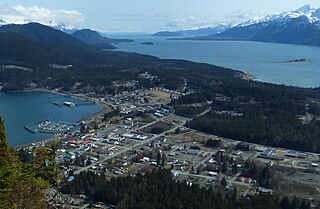
Haines is a census-designated place located in Haines Borough, Alaska, United States. It is in the northern part of the Alaska Panhandle, near Glacier Bay National Park and Preserve.

Eagle is a village on the south bank of the Yukon River near the Canada–US border in the Southeast Fairbanks Census Area, Alaska, United States. It includes the Eagle Historic District, a U.S. National Historic Landmark. The population was 86 at the 2010 census. Every February, Eagle hosts a checkpoint for the long-distance Yukon Quest sled dog race.
The Alaska Highway was constructed during World War II to connect the contiguous United States to Alaska across Canada. It begins at the junction with several Canadian highways in Dawson Creek, British Columbia, and runs to Delta Junction, Alaska, via Whitehorse, Yukon. When it was completed in 1942, it was about 2,700 kilometres (1,700 mi) long, but in 2012, it was only 2,232 km (1,387 mi). This is due to the continuing reconstruction of the highway, which has rerouted and straightened many sections. The highway opened to the public in 1948. Once legendary for being a rough, challenging drive, the highway is now paved over its entire length. Its component highways are British Columbia Highway 97, Yukon Highway 1, and Alaska Route 2.

The Chilkoot Trail is a 33-mile (53 km) trail through the Coast Mountains that leads from Dyea, Alaska, in the United States, to Bennett, British Columbia, in Canada. It was a major access route from the coast to Yukon goldfields in the late 1890s. The trail became obsolete in 1899 when a railway was built from Dyea's neighbor port Skagway along the parallel White Pass trail.

Haines Junction is a village in Yukon, Canada. It is at Kilometre 1,632 of the Alaska Highway at its junction with the Haines Highway, hence the name of the community. According to the 2021 Census, the population was 688. However, the Yukon Bureau of Statistics lists the population count for 2022 as 1,018.

Writing-on-Stone Provincial Park is located about 100 kilometres (60 mi) southeast of Lethbridge, Alberta, Canada, or 44 kilometres (30 mi) east of the community of Milk River, and straddles the Milk River itself. It is one of the largest areas of protected prairie in the Alberta park system, and serves as both a nature preserve and protection for many First Nations (indigenous) rock carvings and paintings. The park is sacred to the Blackfoot and many other aboriginal tribes.
Police Outpost Provincial Park is a provincial park in southern Alberta, Canada, located 32 kilometers (20 mi) south of Cardston.

The Eldred Rock Light is an historic octagonal lighthouse adjacent to Lynn Canal in Alaska. It is the last of the ten lighthouses constructed in Alaska between 1902 and 1906. It was also the last of 12 manned lighthouses that were started in Alaska. It is listed on the National Register of Historic Places as Eldred Rock Lighthouse.

Fort William H. Seward, also known as Chilkoot Barracks and Haines Mission, is a site at Port Chilkoot in Haines Borough, Alaska, about 0.5 miles (0.80 km) from the city of Haines. It was the last of a series of 11 military posts established in Alaska during the gold rush era, and was Alaska's only military facility between 1925 and 1940. It provided a policing presence for miners moving into the gold mining areas in the Alaskan interior, and a military presence during negotiations over the nearby international border with Canada. The fort is named for William H. Seward, the United States Secretary of State who oversaw the Alaska purchase.
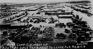
The Village of Columbus and Camp Furlong is a National Historic Landmark District commemorating the 1916 raid by Pancho Villa on the town of Columbus, New Mexico, and the American military response to that raid, the "Punitive Expedition" led by General John J. Pershing. The raid and its response, set during World War I, the Mexican Revolution, and an accompanying low-level Border War, played a significant role in diplomacy and military preparedness for eventual American entry in the World War. The district encompasses buildings which survived the raid, and military facilities used in the American response. The landmark designation was made in 1975.

The Skagway Historic District and White Pass is a National Historic Landmark District encompassing a significant portion of the area within the United States associated with the Klondike Gold Rush. It includes the historic portion of Skagway, Alaska, including the entire road grid of the 1897 town, as well as the entire valley on the United States side of White Pass all the way to the Canada–US border. This area includes surviving fragments of three historic routes used during the Gold Rush, as well as the route of the White Pass and Yukon Railroad. Almost 100 buildings remain from the Gold Rush period. Portions of the district are preserved as part of Klondike Gold Rush National Historical Park.
Pleasant Camp may refer to:

The Bremner Historic Mining District is a historic district in Wrangell-St. Elias National Park and Preserve in Alaska. It is named after John Bremner, who in 1884-1885 was the first non-native person to live in the area and who prospected for gold along the Bremner River. Located just to the north of the Bremner River, it was the scene of an important placer gold discovery in 1902, and played a key role in the history of the Copper River Basin. Only a few miners struck it rich, but the resulting demand for materials and supplies helped establish regional transportation networks, encouraged supporting industries, and hastened the exploration and settlement of the entire region. While small-scale placer mining continued for over forty years, lode development was largely confined to the period between 1934 and 1941, the district's most significant era.

This is a list of the National Register of Historic Places listings in Haines Borough, Alaska.
The Charlie Anway Cabin is a historic log cabin near Haines, Alaska, United States. It was built out of hewn logs in 1903 by Charles H. Anway, the first homesteader to settle in the Haines area. When first built, the cabin was L-shaped with a cross-gable roof with wood shingles. Anway later extended the building, giving it a T shape, and added a layer of metal from flattened cans; the roof has since been covered in galvanized corrugated sheet metal. Anway settled here and eventually produced crops which he sold at Fort William H. Seward. He farmed until 1932, and died in 1949. The cabin and two outbuildings are now owned by the Chilkoot Valley Historical Society.

The Dalton Cache–Pleasant Camp Border Crossing connects the towns of Haines, Alaska and Haines Junction, Yukon on the Canada–United States border. Alaska Route 7 on the American side joins Yukon Highway 3 on the Canadian side as part of the Haines Highway.

Porcupine is a ghost town and former mining community in Haines Borough, Alaska. It is located about 1 mile (1.6 km) southwest of Mile 35 of the Haines Highway, across the Klehini River. Gold was discovered along Porcupine Creek in 1898, and a seasonal community sprang up in the area. Due to the transient nature of the population, permanent structures were only gradually added to the area. At the time the Porcupine District was listed on the National Register of Historic Places in 1976, about 25 structures were still standing in the area, in various stages of decay. Most of these were built during the period 1927–36, when the Sunshine Mining Company was the largest operator in the area.
The Negilik Site, also known as Woods' Camp, is a historic and prehistoric site on the banks of the Colville River of Arctic Alaska, United States. The lowest levels of the site include evidence of prehistoric occupation that has by traditional accounts been associated with trading activities, and includes the remains of a sod house. The area was in 1949 occupied by the Alaska Native Woods family, who built a frame house and dug an ice cellar for use as a seasonal fishing outpost.

Fort Spokane was a frontier outpost in the northwest United States, located in Lincoln County, Washington, approximately fifty miles (80 km) west-northwest of Spokane. At the confluence of the Columbia and Spokane rivers, the U.S. Army post was used to separate the Colville and Spokane tribes on their reservations from the newly established city of Spokane. The fort was last used in 1929 and was later incorporated into the Lake Roosevelt National Recreation Area and is listed on the National Register of Historic Places.


