
Cooper County is a county located in the central portion of the U.S. state of Missouri. As of the 2010 census, the population was 17,601. Its county seat is Boonville. The county was organized December 17, 1818 and named for Sarshell Cooper, a frontier settler who was killed by Native Americans near Arrow Rock in 1814. It is a part of the Columbia, Missouri metropolitan area.

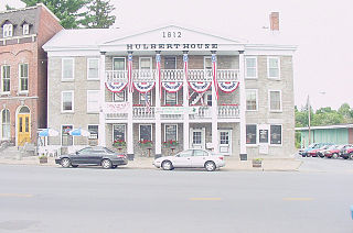
Boonville is a city in Cooper County, Missouri, United States. The population was 8,319 at the 2010 census. It is the county seat of Cooper County. The city was the site of a skirmish early in the Civil War, on July 17, 1861. Union forces defeated a small and poorly equipped force of the Missouri State Guard in the first Battle of Boonville. It is part of the Columbia, Missouri metropolitan area
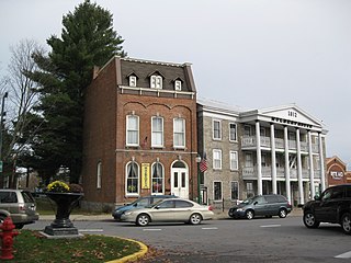
Boonville is a village in Oneida County, New York, United States. The population was 2,072 at the 2010 census. The village is named after Gerrit Boon, an agent of the Holland Land Company.

Boonville is a town in Oneida County, New York, USA. The town is in the northeast of the county. The population was 4,555 at the 2010 census. The town includes a village, also called Boonville. The town and village are named after Gerrit Boon, an agent of the Holland Land Company. The current mayor is Eric McIntyre.

Boonville is a census-designated place (CDP) in Mendocino County, California, United States. It is located 12.5 miles (20 km) southwest of Ukiah, at an elevation of 381 feet. The population was 1,035 at the 2010 census.
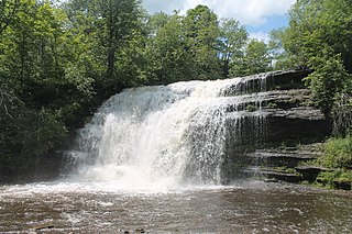
Pixley Falls State Park is a 375-acre (1.52 km2) New York state park located in the town of Boonville in Oneida County, New York, United States. The park is located on New York State Route 46 and is 18 miles (29 km) north of Rome and six miles (9.7 km) southwest of Boonville, near the community of Hurlbutville.

The First Battle of Boonville was a minor skirmish of the American Civil War, occurring on June 17, 1861, near Boonville in Cooper County, Missouri. Although casualties were extremely light, the battle's strategic impact was far greater than one might assume from its limited nature. The Union victory established what would become an unbroken Federal control of the Missouri River, and helped to thwart efforts to bring Missouri into the Confederacy.

New York State Route 12D (NY 12D) is a north–south state highway located in the northern part of New York in the United States. The southern terminus of the route is in the Oneida County village of Boonville, where it intersects NY 12. The northern terminus is at a junction with NY 12 in the Lewis County village of Lyons Falls. NY 46 and NY 294 are also present in the immediate area of the route's southern terminus.

New York State Route 294 (NY 294) is an east–west state highway in northern New York in the United States. It extends for just under 7 miles (11 km) from an intersection with NY 26 in the Lewis County town of Lewis to a junction with NY 46 in the Oneida County village of Boonville. The route serves the hamlet of West Leyden at its western terminus and the community of Redmond Center in the Oneida County town of Ava. NY 294 was assigned as part of the 1930 renumbering of state highways in New York.

Boonville High School is a public high school located in Boonville, Indiana. The school is one of three in Warrick County, that make up the Warrick County School Corporation.

New York State Route 46 (NY 46) is a state highway in Central New York in the United States. It extends from NY 12B in the Madison County town of Eaton to NY 12D in the Oneida County village of Boonville. NY 46 passes through the cities of Oneida and Rome.

Henry Wilbur Bentley was an American politician and a U.S. Representative from New York.

US Post Office-Boonville is a historic post office building located at Boonville in Oneida County, New York, United States. It was designed and built in 1937, and is one of a number of post offices in New York State designed by the Office of the Supervising Architect of the Treasury Department, Louis A. Simon. It is a one-story, five bay building with a poured concrete foundation and brick facades in the Colonial Revival style. It features a hipped roof surmounted by an octagonal cupola with metal window tracery and an iron weathervane. The interior features a mural painted by the McCullough sisters of New York City depicting a 19th-century scene on the Black River Canal. It is a contributing structure within the Boonville Historic District.
Boonville Village Historic District is a national historic district located at Boonville in Oneida County, New York. The district includes 74 contributing buildings, two contributing structures, and two contributing sites. It includes a grouping of architecturally significant buildings that front on the triangular intersection created by Main, Post, and East Schuyler streets. Located within the district are the separately listed Erwin Library and Pratt House and US Post Office-Boonville.

Alder Creek is a hamlet in Oneida County, New York, United States. The community is located at the intersection of New York State Route 12 and New York State Route 28 6.9 miles (11.1 km) southeast of Boonville. Alder Creek has a post office with ZIP code 13301.
Woodgate is a hamlet in Oneida County, New York, United States. The community is located along New York State Route 28 9.5 miles (15.3 km) east-northeast of Boonville. Woodgate has a post office with ZIP code 13494, which opened on December 19, 1878.
Park Hill is a summit located in Central New York Region of New York located in the Town of Boonville in Oneida County, east of Boonville.
Sperry Hill is a summit located in Central New York Region of New York located in the Town of Boonville in Oneida County, east of Boonville.
Jackson Hill is a summit located in Central New York Region of New York located in the Town of Boonville in Oneida County, south of Boonville.
Potato Hill may refer to several places:


