Prairie Farm, Wisconsin

Last updated

Prairie Farm, Wisconsin
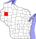
Barron County Wisconsin Incorporated and Unincorporated areas Prairie Farm Highlighted.svg
Location of Prairie Farm in Barron County, Wisconsin
Coordinates: 45°15′7″N91°58′39″W / 45.25194°N 91.97750°W / 45.25194; -91.97750
Country Flag of the United States.svg  United States
State Flag of Wisconsin.svg  Wisconsin
County Barron
Area
[1]
  Total1.00 sq mi (2.58 km2)
  Land0.96 sq mi (2.49 km2)
  Water0.04 sq mi (0.09 km2)
Elevation
[2]
1,043 ft (318 m)
Population
 (2020) [3]
  Total494
  Density490/sq mi (190/km2)
Time zone UTC-6 (Central (CST))
  Summer (DST) UTC-5 (CDT)
Area code(s) 715 & 534
FIPS code 55-65150 [4]
GNIS feature ID1571876 [2]

Prairie Farm is a village in Barron County in the U.S. state of Wisconsin. The population was 494 at the 2020 census. The village is located within the Town of Prairie Farm, on eastern shore of the Prairie Farm Flowage, a reservoir on the Hay River.

Contents

Geography

Prairie Farm is located at 45°14′18″N91°58′50″W / 45.23833°N 91.98056°W / 45.23833; -91.98056 (45.238443, -91.980591). [5]

According to the United States Census Bureau, the village has a total area of 1.01 square miles (2.62 km2), of which, 0.97 square miles (2.51 km2) is land and 0.04 square miles (0.10 km2) is water. [6]

Prairie Farm is located along County Roads A and F.

Demographics

Historical population
CensusPop.Note
1880 80
1910 368
1920 299−18.7%
1930 3010.7%
1940 33511.3%
1950 3432.4%
1960 3502.0%
1970 42621.7%
1980 387−9.2%
1990 49427.6%
2000 5082.8%
2010 473−6.9%
2020 4944.4%
U.S. Decennial Census [7]

2010 census

As of the census [8] of 2010, there were 473 people, 201 households, and 114 families living in the village. The population density was 487.6 inhabitants per square mile (188.3/km2). There were 227 housing units at an average density of 234.0 per square mile (90.3/km2). The racial makeup of the village was 98.5% White, 0.2% Native American, 0.8% from other races, and 0.4% from two or more races. Hispanic or Latino people of any race were 2.1% of the population.

There were 201 households, of which 26.9% had children under the age of 18 living with them, 43.3% were married couples living together, 8.5% had a female householder with no husband present, 5.0% had a male householder with no wife present, and 43.3% were non-families. 36.3% of all households were made up of individuals, and 16.9% had someone living alone who was 65 years of age or older. The average household size was 2.16 and the average family size was 2.83.

The median age in the village was 44.9 years. 21.1% of residents were under the age of 18; 5.2% were between the ages of 18 and 24; 24.1% were from 25 to 44; 26.2% were from 45 to 64; and 23.5% were 65 years of age or older. The gender makeup of the village was 45.9% male and 54.1% female.

2000 census

As of the census [4] of 2000, there were 508 people, 199 households, and 119 families living in the village. The population density was 524.1 people per square mile (202.2/km2). There were 208 housing units at an average density of 214.6 per square mile (82.8/km2). The racial makeup of the village was 99.41% White, 0.39% Native American, and 0.20% from two or more races. Hispanic or Latino people of any race were 3.15% of the population.

There were 199 households, out of which 27.6% had children under the age of 18 living with them, 50.3% were married couples living together, 5.5% had a female householder with no husband present, and 39.7% were non-families. 31.7% of all households were made up of individuals, and 17.6% had someone living alone who was 65 years of age or older. The average household size was 2.36 and the average family size was 3.03.

In the village, the population was spread out, with 22.2% under the age of 18, 6.9% from 18 to 24, 24.2% from 25 to 44, 23.4% from 45 to 64, and 23.2% who were 65 years of age or older. The median age was 42 years. For every 100 females, there were 92.4 males. For every 100 females age 18 and over, there were 89.9 males.

The median income for a household in the village was $38,000, and the median income for a family was $41,667. Males had a median income of $27,206 versus $21,917 for females. The per capita income for the village was $15,638. About 5.8% of families and 7.8% of the population were below the poverty line, including 3.6% of those under age 18 and 15.9% of those age 65 or over.

Related Research Articles

<span class="mw-page-title-main">Deer Park, Illinois</span> Village in Illinois, United States

Deer Park is a village in Lake and Cook Counties, Illinois. Per the 2020 census, the population was 3,681. The village is one of the few left in the Chicago area that enjoy a green belt which is bordered by two large natural areas providing outdoor recreation and open space. The village is home to popular shopping and dining destinations: Deer Park Town Center and the Town Center Promenade. The town is also home to the Vehe Farm, an Illinois Centennial Farm.

<span class="mw-page-title-main">Prairie Grove, Illinois</span> Village in Illinois, United States

Prairie Grove is a village in McHenry County, Illinois, United States, first incorporated in 1973. Per the 2020 census, the population was 1,963.

<span class="mw-page-title-main">Wellman, Iowa</span> City in Iowa, United States

Wellman is a city in Washington County, Iowa, United States. It is part of the Iowa City, Iowa Metropolitan Statistical Area. The population was 1,524 at the time of the 2020 census.

<span class="mw-page-title-main">Hay Township, Michigan</span> Civil township in Michigan, United States

Hay Township is a civil township of Gladwin County in the U.S. state of Michigan. The population was 1,279 at the 2020 census.

<span class="mw-page-title-main">Climax, Michigan</span> Village in Michigan, United States

Climax is a village in Kalamazoo County in the U.S. state of Michigan. The population was 767 at the 2010 census. The village is located within Climax Township on the northern boundary with Charleston Township, and is roughly 12 miles (19 km) west of Battle Creek and 16 miles (26 km) east of Kalamazoo. Climax shares a school district with the neighboring town of Scotts.

<span class="mw-page-title-main">Richland, Michigan</span> Village in Michigan, United States

Richland is a village in Kalamazoo County in the U.S. state of Michigan. The population was 751 at the 2010 census, up from 593 at the 2000 census.

<span class="mw-page-title-main">Bingham Farms, Michigan</span> Village in Michigan, United States

Bingham Farms is a village in Oakland County in the U.S. state of Michigan. A northern suburb of Detroit, Bingham Farms is located within Southfield Township, roughly 20 miles (32.2 km) northwest of downtown Detroit. As of the 2020 census, the village had a population of 1,124.

Forest Prairie Township is a township in Meeker County, Minnesota, United States. The population was 869 at the 2000 census.

<span class="mw-page-title-main">Louisburg, Missouri</span> Village in Missouri, United States

Louisburg is a village in Dallas County, Missouri, United States. The population was 122 at the 2010 census. It is part of the Springfield, Missouri Metropolitan Statistical Area.

<span class="mw-page-title-main">Grantwood Village, Missouri</span> Town in Missouri, United States

Grantwood Village is a town in St. Louis County, Missouri, United States. The population was 863 at the 2010 census.

<span class="mw-page-title-main">Prairie Rose, North Dakota</span> City in North Dakota, United States

Prairie Rose is a city in Cass County, North Dakota, United States. The population was 56 at the 2020 census. The city is an enclave suburb of Fargo. Prairie Rose was founded in 1975 and it was incorporated in 1978. There are 21 homes in the city.

<span class="mw-page-title-main">Caledonia, Ohio</span> Village in Ohio, United States

Caledonia is a village in Marion County, Ohio, United States. The population was 560 at the 2020 census.

<span class="mw-page-title-main">Grays Prairie, Texas</span> Village in Texas, United States

Grays Prairie is a village in Kaufman County, Texas, United States. Its population was 325 at the 2020 census.

<span class="mw-page-title-main">South Prairie, Washington</span> Town in Pierce County, Washington, United States

South Prairie is a town in Pierce County, Washington, United States. The population was 373 at the 2020 census.

Rome is a census-designated place (CDP) in the town of Sullivan in Jefferson County, Wisconsin, United States, along the Bark River. The population was 752 at the 2020 census.

Jeanette Lake is an unorganized territory in Saint Louis County, Minnesota, United States. The population was 249 at the 2000 census.

<span class="mw-page-title-main">Dallas, Wisconsin</span> Village in Wisconsin, United States

Dallas is a village in Barron County in the U.S. state of Wisconsin. The population was 359 at the 2020 census. The village is located within the Town of Dallas.

Prairie Farm is a town in Barron County in the U.S. state of Wisconsin. The population was 566 at the 2020 census, down from 573 at the 2010 census. The village of Prairie Farm is surrounded by the town.

<span class="mw-page-title-main">Prairie du Sac, Wisconsin</span> Village in Wisconsin, United States

Prairie du Sac is a village in Sauk County, Wisconsin, United States, located along the Wisconsin River. The population was 4,420 at the 2020 census. The village is surrounded by the Town of Prairie du Sac, the Wisconsin River, and the village of Sauk City; together, Prairie du Sac and Sauk City are referred to as Sauk Prairie.

<span class="mw-page-title-main">Star Prairie, Wisconsin</span> Village in Wisconsin, United States

Star Prairie is a village in St. Croix County in the U.S. state of Wisconsin. The population was 561 at the 2010 census. The village is located along the Apple River on the boundary between the Town of Star Prairie and the Town of Stanton.

References

  1. "2019 U.S. Gazetteer Files". United States Census Bureau. Retrieved August 7, 2020.
  2. 1 2 "US Board on Geographic Names". United States Geological Survey. October 25, 2007. Retrieved January 31, 2008.
  3. "Census Bureau profile: Prairie Farm village, Wisconsin". United States Census Bureau. May 2023. Retrieved October 29, 2024.
  4. 1 2 "U.S. Census website". United States Census Bureau . Retrieved January 31, 2008.
  5. "US Gazetteer files: 2010, 2000, and 1990". United States Census Bureau. February 12, 2011. Retrieved April 23, 2011.
  6. "US Gazetteer files 2010". United States Census Bureau. Archived from the original on January 25, 2012. Retrieved November 18, 2012.
  7. "Census of Population and Housing". Census.gov. Retrieved June 4, 2015.
  8. "U.S. Census website". United States Census Bureau . Retrieved November 18, 2012.