Pureair, Wisconsin

Last updated

Pureair, Wisconsin
USA Wisconsin location map.svg
Red pog.svg
Pureair
Usa edcp location map.svg
Red pog.svg
Pureair
Coordinates: 46°47′25″N90°50′51″W / 46.79028°N 90.84750°W / 46.79028; -90.84750
Country Flag of the United States.svg United States
State Flag of Wisconsin.svg Wisconsin
County Bayfield
Town Bayfield
Elevation
200 m (650 ft)
Time zone UTC-6 (Central (CST))
  Summer (DST) UTC-5 (CDT)
Area codes 715 and 534
GNIS feature ID1577781 [1]

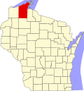
Pureair is an unincorporated community located in the town of Bayfield, Bayfield County, Wisconsin, United States. [1]

History

The area was named after the Pureair Sanatorium which treated tuberculosis patients from Bayfield County, Iron County and Ashland County, as well as some veterans of World War I, between the years 1920–1975. The sanatorium has since been demolished. [2] [3]

Notes

  1. 1 2 "Pureair, Wisconsin". Geographic Names Information System . United States Geological Survey, United States Department of the Interior.
  2. "An analysis of Dane County Lakeview Sanatorium property". The Real Estate Collection. Retrieved December 1, 2014.
  3. "Pureair Sanatorium". MBendi Information services.