Pureair, Wisconsin | |
---|---|
Coordinates: 46°47′25″N90°50′51″W / 46.79028°N 90.84750°W Coordinates: 46°47′25″N90°50′51″W / 46.79028°N 90.84750°W | |
Country | United States |
State | Wisconsin |
County | Bayfield |
Town | Bayfield |
Elevation | 200 m (650 ft) |
Time zone | UTC-6 (Central (CST)) |
• Summer (DST) | UTC-5 (CDT) |
Area code(s) | 715 and 534 |
GNIS feature ID | 1577781 [1] |
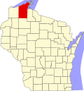
Pureair is an unincorporated community located in the town of Bayfield, Bayfield County, Wisconsin, United States. [1]
The area was named after the Pureair Sanatorium which treated tuberculosis patients from Bayfield County, Iron County and Ashland County, as well as some veterans of World War I, between the years 1920–1975. The sanatorium has since been demolished. [2] [3]
Bayfield County is the northernmost county in the U.S. state of Wisconsin. As of the 2010 census, the population was 15,014. Its county seat is Washburn. The county was created in 1845 and organized in 1850.
Ashland County is a county located in the U.S. state of Wisconsin. As of the 2010 census, the population was 16,157. Its county seat is Ashland. The county was formed on March 27, 1860, from La Pointe County.
Bayfield is a city in Bayfield County, Wisconsin, United States. The population was 487 at the 2010 census. This makes it the city with the smallest population in Wisconsin. In fact, for a new city to be incorporated today, state regulations require a population of at least 1,000 residents, so it would have to be incorporated as a village instead.
Benoit is an unincorporated community in the towns of Keystone and Mason, Bayfield County, Wisconsin, United States. It is along County Highway F. Benoit is 13 miles southwest of the city of Ashland. Nearby is the junction of U.S. Highway 2 and U.S. Highway 63.
Red Cliff, also known as Miskwaabikaang, is an unincorporated community in the town of Russell, Bayfield County, Wisconsin, United States. Red Cliff is the administrative center of the Red Cliff Band of Lake Superior Chippewa. The reservation population is 924, primarily Native American.
Port Wing is an unincorporated census-designated place in the town of Port Wing, Bayfield County, Wisconsin, United States. The community is along Wisconsin Highway 13 and Bayfield County Highway A. It is 30 miles (48 km) west of Bayfield. The Flag River enters Lake Superior at Port Wing's harbor.
Salmo is an unincorporated community in Bayfield County, Wisconsin, United States.
Sand Bay is an unincorporated community in the town of Russell, Bayfield County, Wisconsin, United States. The community is located within the Red Cliff Indian Reservation.
Barksdale is an unincorporated community in the town of Barksdale, Bayfield County, Wisconsin, United States. Barksdale is located on Wisconsin Highway 13 4 miles (6.4 km) south-southwest of Washburn.
Bark Point is an unincorporated community in the town of Clover, Bayfield County, Wisconsin, United States. Bark Point is located on Lake Superior at the tip of a landmass also called Bark Point, 5 miles (8.0 km) northeast of Herbster and 18 miles (29 km) west-northwest of Bayfield.
Ashland Junction is an unincorporated community located in the town of Eileen, Bayfield County, Wisconsin, United States.
Pike River is an unincorporated community located in the town of Delta, Bayfield County, Wisconsin, United States.
Sutherland is an unincorporated community located in the towns of Delta and Mason, Bayfield County, Wisconsin, United States.
Leonards is an unincorporated community located in the town of Cable, Bayfield County, Wisconsin, United States.
Radspur is an unincorporated community located in the town of Cable, Bayfield County, Wisconsin, United States.
Wills is an unincorporated community located in the town of Hughes, Bayfield County, Wisconsin, United States.
Muskeg is an unincorporated community located in the town of Hughes, Bayfield County, Wisconsin, United States.
Oulu is an unincorporated community in the town of Oulu, Bayfield County, Wisconsin, United States. Oulu is located at the junction of County Highways B and FF 7.5 miles (12.1 km) northwest of Iron River.
Topside is an unincorporated community in the town of Iron River, Bayfield County, Wisconsin, United States. Topside is located near U.S. Route 2, 4.1 miles (6.6 km) east of the community of Iron River.
Pureair Sanatorium is located in Bayfield County, Wisconsin.