Republic Square (Austin)

Last updated

Republic Square
Hamilton Square (1888-1976)
Republic Square Patio Austin 2020.jpg
Republic Square (Austin)
TypePublic park
Location422 Guadalupe St
Austin, Texas 78703
Coordinates 30°16′04″N97°44′50″W / 30.2678°N 97.7473°W / 30.2678; -97.7473
Area1 acre (0.40 ha) [1]
Created1888 (1888)

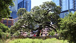
Republic Square is an urban park in central Austin, Texas. Located in Downtown Austin, the park features a grassy area meant for festivals and events as well as shaded areas under live oak trees. The SFC Farmers' Market meets at the square every Saturday morning. [2] [ failed verification ]

Contents

History

Originally called "Hamilton Square", Republic Square was one of four public squares laid out in the 1839 Waller Plan of Austin by Edwin Waller. [3] The square functioned as a normal urban park up until the mid-twentieth century when it served as a parking lot. [3] The neighborhood surrounding the park became significant for its Mexican American residents throughout the late 1800s and early 1900s. [4] During the United States Bicentennial, the city of Austin transformed the square to its former glory, and was later revitalized again in 2017. [5] Despite many physical changes, the historic heritage Auction Oaks survived and remain a centerpiece to the square till this day. [6]

Transportation hub

Republic Square also functions as a downtown hub for the Capital Metropolitan Transportation Authority bus system, CapMetro Bus. Austin's central bus-rapid transit system, CapMetro Rapid Lines 801 and 803 share a stop next to the square (Fourth Street/Guadalupe Street for southbound buses and Fourth Street/Lavaca Street for northbound). Republic Square station provides transit travelers the option to transfer to local lines, as well as Route 20 to Austin–Bergstrom International Airport. [7] Republic Square was also a proposed stop for the Project Connect's Downtown Transit Tunnel, however, as of June 1, 2023, Republic Square is no longer a planned route on at least the light rail in the scaled back plans. [8] [9]

Related Research Articles

<span class="mw-page-title-main">Los Angeles County Metropolitan Transportation Authority</span> Public transport agency in Los Angeles County, California, United States

The Los Angeles County Metropolitan Transportation Authority (LACMTA), branded as Metro, is the county agency that plans, operates, and coordinates funding for most of the public transportation system in Los Angeles County, California, the most populated county in the United States.

<span class="mw-page-title-main">Metro Transit (Minnesota)</span> Public transit operator in the Twin Cities region of Minnesota

Metro Transit is the primary public transportation operator in the Minneapolis–Saint Paul area of the U.S. state of Minnesota and the largest operator in the state. In 2023, the system had a ridership of 44,977,200, or about 144,300 per weekday as of the second quarter of 2024.

Oklahoma City is near the geographic center of the United States and is an integral point on the U.S. Interstate Network. The city is served by numerous roads and highways, toll roads, three major airports, a train station, a bus station, and a transit system.

The Capital Metropolitan Transportation Authority, officially stylized as CapMetro, is a public transportation provider located in Austin, Texas. It operates bus, paratransit services and a hybrid rail system known as CapMetro Rail in Austin and several suburbs in Travis and Williamson counties. In 2023, the system had a ridership of 25,229,400, or about 81,800 per weekday as of the second quarter of 2024.

<span class="mw-page-title-main">CapMetro Rail</span> Hybrid rail system in Austin, Texas

CapMetro Rail is a hybrid rail system that serves the Greater Austin area in Texas and is owned by CapMetro, Austin's primary public transportation provider. The Red Line is CapMetro's first and currently only rail line, and connects Downtown Austin with Austin's northwestern suburbs. The line operates on 32 miles (51 km) of existing freight tracks, and serves 10 stations. After a series of delays, CapMetro Rail was inaugurated in March 2010. CapMetro added Friday evening and Saturday afternoon and evening regularly scheduled service on March 23, 2012. In 2023, the line had a ridership of 485,400, or about 1,600 per weekday as of the second quarter of 2024.

The Minneapolis Streetcar System was a proposed streetcar system for the city of Minneapolis, Minnesota. Extensive studies and plans for the new system were completed in 2007 and presented to the Minneapolis City Council in January 2008; on April 2, 2010, the Council voted to approve the plans and seek funding. On December 21, 2010 the Federal Transit Administration granted $900,000 to further study the Nicollet and Central Avenue corridors. In June 2021, after no further development on the system, a bill authorized the Metropolitan Council to use funds collected for the Nicollet-Central line to be spent on bus rapid transit funding.

<span class="mw-page-title-main">MBTA subway</span> Boston region transit service

The Massachusetts Bay Transportation Authority (MBTA) operates rapid transit, light rail, and bus rapid transit services in the Boston metropolitan area, collectively referred to as the rapid transit, subway, the T system, or simply the T.

<span class="mw-page-title-main">Pioneer Square station</span> Light rail station in Seattle, Washington

Pioneer Square station is a light rail station that is part of the Downtown Seattle Transit Tunnel in Seattle, Washington, United States. The station is located under 3rd Avenue at James Street, between Symphony and International District/Chinatown stations. It is served by the 1 Line, part of Sound Transit's Link light rail system, and provides connections to local buses and Colman Dock, a major ferry terminal serving areas west of Seattle.

<span class="mw-page-title-main">Westlake station (Sound Transit)</span> Light rail station in Seattle, Washington

Westlake station is a light rail station that is part of the Downtown Seattle Transit Tunnel in Seattle, Washington, United States. The station is located under Pine Street between 3rd and 6th avenues in Downtown Seattle, near Westlake Center and Westlake Park. It is served by the 1 Line, part of Sound Transit's Link light rail system, and also connected above ground by buses at several stops, the South Lake Union Streetcar, and the Seattle Center Monorail.

<span class="mw-page-title-main">Crestview station</span> Hybrid rail station in Austin, Texas

Crestview station is a CapMetro Rail hybrid rail station and CapMetro Rapid bus rapid transit station in Austin, Texas. It is at the edge of the Crestview neighborhood of North Austin, at the corner of Airport Boulevard and North Lamar Boulevard. The North Lamar Transit Center is one mile (1.6 km) north of the station, and the Highland Mall Transit Center is 12 mile (0.8 km) to the southeast. There is no on-site parking at the Crestview station. Riders must park at the North Lamar Transit center and take buses 1 or 801 south to the train. With Project Connect, the Blue and Orange Lines will have a connection to this station.

<span class="mw-page-title-main">Metro (Minnesota)</span> Rapid transit network in the Minneapolis metropolitan area of the United States

Metro is a transit network in Minnesota serving the cities of Minneapolis and Saint Paul. It also provides service to some suburban areas. As of 2022, the system consists of two light rail lines and five bus rapid transit (BRT) lines all of which are operated by the local public transit company: Metro Transit. The five lines connect Downtown Minneapolis and St Paul with Bloomington, Minneapolis-St Paul International Airport, Roseville, Richfield, Burnsville and Brooklyn Center.

<span class="mw-page-title-main">CapMetro Rapid</span> Bus rapid transit service in Austin, Texas

CapMetro Rapid is a bus rapid transit service in Austin, Texas, owned and operated by the Capital Metropolitan Transportation Authority (CapMetro). It currently consists of two routes which run north-south served by stations designed by McKinney York Architects.

The Blue Line is a planned light rail line for connecting Austin–Bergstrom International Airport with downtown Austin, Texas. It is still in the planning stages as a part of CapMetro's Project Connect. It is estimated to begin revenue service as early as 2029.

<span class="mw-page-title-main">Urban rail transit in Canada</span> List of Canadian passenger rail systems confined to urban areas

Urban rail transit in Canada encompasses a broad range of rail mass transit systems, including commuter rail, rapid transit, light rail, and streetcar systems.

<span class="mw-page-title-main">Project Connect</span> Ballot measure in Austin, Texas expanding the public transit system

Project Connect is a transit expansion program by the Capital Metropolitan Transportation Authority (CapMetro) in Austin, Texas, U.S. The program was approved by voters on November 3, 2020, in a local election concurrent with the 2020 presidential election.

The Gold Line is a proposed transitway for connecting North Central Austin and the Downtown's Eastside to South Austin. It is in the planning stages as a part of Capital Metro's Project Connect. According to the plan, the line will be initially be operated as a bus rapid transit line prior to future conversion to light rail. It is estimated to open in 2024.

The Orange Line is a proposed north-south light rail line that will serve the central spine of Austin from North Lamar to Stassney Lane. It is in the planning stages as a part of CapMetro's Project Connect. It is estimated to begin revenue service as early as 2029.

<span class="mw-page-title-main">North Lamar Transit Center</span>

North Lamar Transit Center is a Capital Metropolitan Transportation Authority bus station in Austin, Texas. It is located on North Lamar Boulevard on the north side of U.S. Route 183. The station features a park and ride lot and is served by several local bus routes as well as CapMetro Rapid Route 801. As part of Project Connect, a CapMetro Rail light rail station is planned to be built at the facility; it is planned to be the northern terminus of the system.

The Downtown Transit Tunnel was a planned light rail tunnel in Downtown Austin, Texas. It was a core feature of the proposed initial investment of Project Connect, the transit expansion plan being undertaken by the Capital Metropolitan Transportation Authority. The transit tunnel would have served the Orange, Blue, and (eventually) Gold light rail lines. The tunnel was eventually cut from Project Connect plans after unexpected cost increases and design challenges.

References

  1. Bueche, Shelley (July 15, 2019). "Tiny downtown Austin park had a mighty impact on the city's history". CultureMap Austin.
  2. "Sustainable Food Center Farmers' Market Downtown". Sustainable Food Center.
  3. 1 2 "About". Republic Square. March 22, 2017.
  4. "June Park of the Month: Republic Square Park". The Official Website of the City of Austin. May 31, 2012.
  5. "About". Republic Square. March 22, 2017. Retrieved January 18, 2020.
  6. "Republic Square". Austin Parks Foundation. Retrieved January 18, 2020.
  7. "Bus & Rail Service: System Map" (PDF). CapMetro.
  8. Moreno-Lozano, Luz. "Project Connect light rail plan gets stamp of approval from Austin City Council". Austin American-Statesman. Retrieved October 10, 2024.
  9. https://www.projectconnect.com/images/librariesprovider2/2022_projects/light-rail/austin-light-rail-phase-one-map.jpg?sfvrsn=f565005d_3