Retta, Arkansas

Last updated
Retta, Arkansas
USA Arkansas location map.svg
Red pog.svg
Retta, Arkansas
Position in Arkansas
Coordinates: 35°31′00″N92°56′57″W / 35.51667°N 92.94917°W / 35.51667; -92.94917 Coordinates: 35°31′00″N92°56′57″W / 35.51667°N 92.94917°W / 35.51667; -92.94917
Country Flag of the United States.svg  United States
State Flag of Arkansas.svg  Arkansas
County Pope
Elevation
206 m (676 ft)
Time zone UTC-6 (Central (CST))
  Summer (DST) UTC-5 (CDT)
GNIS feature ID73278

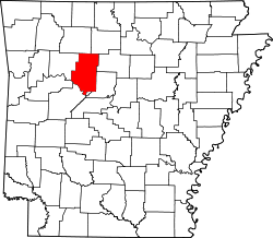
Retta is an unincorporated community in Jackson Township, Pope County, Arkansas, United States. [1] It is a populated place located within the Township of Jackson, a minor civil division (MCD) of Pope County. The elevation of Retta is 679 feet. Retta appears on the Solo U.S. Geological Survey Map. Pope County is in the Central Time Zone (UTC -6 hours). The local timezone is named " America/Chicago''. [2]

Related Research Articles

<span class="mw-page-title-main">Pope County, Arkansas</span> County in Arkansas, United States

Pope County is a county in the U.S. state of Arkansas. As of the 2020 census, the population was 63,381. The county seat is Russellville. The county was formed on November 2, 1829, from a portion of Crawford County and named for John Pope, the third governor of the Arkansas Territory. Pope County was the nineteenth county formed. The county's borders changed eighteen times in the 19th century with the creation of new counties and adjustments between counties. The current boundaries were set on 8 March 1877.

<span class="mw-page-title-main">Jackson County, Arkansas</span> County in Arkansas, United States

Jackson County is located in the Arkansas Delta in the U.S. state of Arkansas. The county is named for Andrew Jackson, a national hero during the War of 1812. By the county's formation in 1829, Jackson had become the seventh President of the United States. Jackson County is home to seven incorporated towns and four incorporated cities, including Newport, the largest city and county seat. The county is also the site of numerous unincorporated communities and ghost towns. Occupying 633.94 square miles (164,190 ha), Jackson County is the 41st largest county of the 75 in Arkansas. As of the 2010 Census, the county's population is 17,997 people in 7,601 households. Based on population, the county is the 40th-largest county in Arkansas. Although terrain rises in the west, most of Jackson County is within the Arkansas Delta, characterized by largely flat terrain with fertile soils. Historically covered in forest, bayous and swamps, the area was cleared for agriculture by early settlers. It is drained by the White River.

<span class="mw-page-title-main">Garland County, Arkansas</span> County in Arkansas, United States

Garland County is located in the U.S. state of Arkansas. As of the 2020 census, the population was 100,180. The county seat is Hot Springs.

Nogo is a small unincorporated community in Smyrna Township, Pope County, Arkansas, United States. It is part of the Russellville Micropolitan Statistical Area.

Jackson Township may refer to the following places:

Jackson Township is one of nineteen current townships in Pope County, Arkansas, USA. As of the 2010 census, its unincorporated population was 1,110.

Jackson Township, Arkansas may refer to:

Appleton is an unincorporated community and census-designated place (CDP) in Griffin Township, Pope County, Arkansas, United States. It was first listed as a CDP in the 2020 census with a population of 399.

Bernice is an unincorporated community in Illinois Township, Pope County, Arkansas, United States. The area, located on Arkansas Highway 7 Truck, is now part of Russellville.

Bullfrog Valley is an unincorporated community in Illinois Township, Pope County, Arkansas, United States. It is located on Arkansas Highway 164 near the Johnson County line. The community is also located north of Silex.

Hogan Township was a township of Pope County, Arkansas. It was located in the central part of the county. Hogan Township was created between 1910 and 1920 using parts from Allen, Jackson, Liberty, Martin and North Fork Townships.

Caglesville is an unincorporated community in Center Township, Pope County, Arkansas, United States. The community was named for N. P. Cagle, a local mill operator.

Center Valley is an unincorporated community in Center Township, Pope County, Arkansas, United States.

Moreland is an unincorporated community in Moreland Township, Pope County, Arkansas, United States.

Oak Grove is an unincorporated community and census-designated place (CDP) in Moreland Township, Pope County, Arkansas, United States. It was first listed as a CDP in the 2020 census with a population of 177.

Sand Gap is an unincorporated community in Freeman Township, Pope County, Arkansas, United States. Sand Gap is located at the junction of Arkansas highways 7 and 16.

Scottsville is an unincorporated community in Liberty Township, Pope County, Arkansas, United States. The community was named for the Scott family, and was named Rocky Point, The Level, and The Levey prior to Scottsville.

Walnut Grove is an unincorporated community in Jackson Township, Pope County, Arkansas, United States. It is located on Walnut Grove Road, east of Hector.

<span class="mw-page-title-main">Jackson Township, Newton County, Arkansas</span> Township in Arkansas, United States

Jackson Township is a township in Newton County, Arkansas, United States. Its total population was 1,620 as of the 2010 United States Census, an increase of 1.76 percent from 1,592 at the 2000 census.

<span class="mw-page-title-main">Jackson Township, Randolph County, Arkansas</span> Township in Arkansas, United States

Jackson Township is a township in Randolph County, Arkansas, United States. Its total population was 241 as of the 2010 United States Census, a decrease of 10.41 percent from 269 in 2000.

References

  1. "Feature Detail Report for: Retta, Arkansas." USGS. Profile. Retrieved June 25, 2010.
  2. "Retta Populated Place Profile / Pope County, Arkansas Data". arkansas.hometownlocator.com. Retrieved 2021-06-14.