
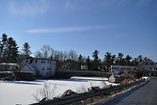
Fallasburg Bridge is a 100-foot (30 m) span Brown truss covered bridge, erected in 1871 in Vergennes Township, Michigan, United States, 5 miles (8.0 km) north of Lowell on the Flat River. Carrying Covered Bridge Road across the Flat, it is located in the Fallasburg Historical District south of Whites Bridge and Smyrna. It is listed on the National Register of Historic Places, and along with Whites Bridge, Langley Covered Bridge, and Zehnder's Holz Brucke, is one of only four Michigan covered bridges open to vehicle traffic.

Kenduskeag Stream is a 36.2-mile (58.3 km) stream in the U.S. state of Maine. It is a tributary of the Penobscot River. The stream rises at the outlet of Garland Pond in the town of Garland, and flows southeast through Corinth, Kenduskeag, and Glenburn, before it reaches the city of Bangor. Passing through downtown Bangor, the stream drops 100 feet (30 m) in 2 miles (3 km), flowing into the Penobscot between the two downtown bridges across the larger river. Kenduskeag means "eel weir place" in Penobscot.

The Columbia Bridge is a covered bridge, carrying Columbia Bridge Road over the Connecticut River between Columbia, New Hampshire and Lemington, Vermont. Built in 1911–12, it is one of only two New Hampshire bridges built with Howe trusses, and is one of the last covered bridges built in the historic era of covered bridge construction in both states. It was listed on the National Register of Historic Places in 1976.

The Mount Orne Bridge is a covered bridge over the Connecticut River between Lancaster, New Hampshire, and Lunenburg, Vermont. It joins Elm Street in South Lancaster with River Road in Lunenburg. Built in 1911, it is one of two Howe truss bridges across the Connecticut River. It was listed on the National Register of Historic Places in 1976.

The County Farm Bridge was a historic covered bridge spanning the Cocheco River in Dover, New Hampshire. A Howe truss bridge, it was built about 1875 to serve the adjacent county farm complex, and was destroyed by fire in 1981. It was listed on the National Register of Historic Places in 1975. The bridge site now has a pedestrian bridge.

Watson Settlement Bridge was an historic covered bridge in eastern Littleton, Maine, United States. Built in 1911, it was one of the youngest of Maine's few surviving covered bridges. It formerly carried Framingham Road over the Meduxnekeag River, but was closed to traffic, the road passing over a modern bridge to its south. It was listed on the National Register of Historic Places in 1970. It was destroyed by fire on July 19, 2021.
The Goffstown Covered Railroad Bridge was a rare railroad covered bridge in Goffstown, New Hampshire. It was built in 1901 by the Boston and Maine Railroad, on the site of an earlier bridge built in 1850 by the New Hampshire Central Railroad, and carried its tracks across the Piscataquog River in the center of Goffstown. The bridge was listed on the National Register of Historic Places in 1975. It was destroyed by arson in 1976, as would later be the case with the Hillsborough Railroad Bridge in 1985.
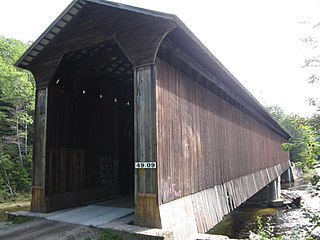
Wright's Bridge is a historic covered bridge in Newport, New Hampshire. Originally built in 1906 to carry the Boston and Maine Railroad across the Sugar River, it now carries the multi-use Sugar River Trail. The bridge was listed on the National Register of Historic Places in 1975.

The Hemlock Bridge is a covered bridge in a rural part of Fryeburg, Maine. Built in 1857, it carries Hemlock Bridge Road over the Old Course Saco River, near the western shore of Kezar Lake in eastern Fryeburg. It is the last surviving 19th-century covered in Fryeburg. It was listed on the National Register of Historic Places in 1970 and designated as a Maine Historic Civil Engineering Landmark by the American Society of Civil Engineers in 2002.

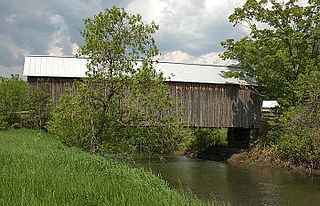
The Porter-Parsonsfield Bridge is a covered bridge in western Maine, and one of the few 19th-century covered bridges left in the state. The bridge spans the Ossipee River just east of the modern alignment of North Road, which it formerly carried, between the towns of Porter and Parsonsfield. Built in 1876 by the towns, it is a Paddleford truss bridge which has been strengthened with laminated arches. The bridge was closed to traffic in 1960, and is now maintained by the state. It was listed on the National Register of Historic Places in 1970.

The Waterman Covered Bridge was an historic covered bridge in Johnson, Vermont that carried Waterman Road across Waterman Creek. Built in 1868, it was one of three surviving 19th-century bridges in the town. It was listed on the National Register of Historic Places in 1974, and collapsed in January 1982.

The Ryefield Bridge is a historic bridge connecting Ryefield Bridge Road in Harrison, Maine, to West Andrew Hill Road in Otisfield, Maine, across the Crooked River. Built in 1912, it is one of the oldest surviving Warren truss bridges in the state, and is a rare example with double-intersection diagonals, added for increased rigidity. The bridge was listed on the National Register of Historic Places in 1999.

The New Portland Wire Bridge is a historic suspension bridge in New Portland, Maine. The bridge carries Wire Bridge Road across the Carrabassett River a short way north of the village center. Built in the mid-19th century, it is one of four 19th-century suspension bridges in the state. It is one lane wide, and has a weight limit of 3 tons. The bridge was listed on the National Register of Historic Places in 1970 and was designated as a Maine Historic Civil Engineering Landmark by the American Society of Civil Engineers in 1990.

The Cooley Covered Bridge is a covered bridge that carries Elm Street across Furnace Brook in Pittsford, Vermont. Built in 1849, it is one of a small number of bridges in the state that has a well-documented association with the 19th-century master bridgewright Nicholas M. Powers, who grew up nearby. It is one of four surviving 19th-century covered bridges in the town, and was listed on the National Register of Historic Places in 1974.

The Cilley Covered Bridge is a historic 19th-century covered bridge, carrying Howe Lane across the First Branch White River a short way south of the village of Tunbridge, Vermont. Built in 1883, it is a fine example of a king-post truss structure, and is one of the town's five 19th-century covered bridges. It was listed on the National Register of Historic Places in 1974.
The Howe Covered Bridge is a historic covered bridge carrying Belknap Brook Road across the White River in Tunbridge, Vermont, just east of Vermont Route 110. Built in 1879, it is one of five surviving bridges in the town, one of the highest concentrations of covered bridges in the state. It was listed on the National Register of Historic Places in 1974.

The Mill Covered Bridge is a replica historic covered bridge carrying Spring Road across the First Branch White River in Tunbridge, Vermont. It was built in 2000, nearly replicating a previous structure built on the site in 1883 and lost due to ice damage. It is one of a high concentration of covered bridges in Tunbridge and Chelsea. The 1883 bridge was listed on the National Register of Historic Places in 1974.

The Union Village Covered Bridge is a historic covered bridge, carrying Academy Road across the Ompompanoosuc River in Union Village, Thetford, Vermont. Built in 1867, it is the state's longest 19th-century multiple kingpost truss bridge. It was listed on the National Register of Historic Places in 1974.

The Burrington Covered Bridge is a historic queenpost truss covered bridge in Lyndon, Vermont. Built in the 19th century, it is one of five covered bridges in Lyndon. It formerly carried Burrington Bridge Road across the Passumpsic River; it has been bypassed by a modern bridge. It was listed on the National Register of Historic Places in 1974.

The Greenbanks Hollow Covered Bridge is a historic covered bridge, carrying Greenbanks Hollow Road across Joes Brook in southern Danville, Vermont. It is the only surviving 19th-century covered bridge in the town. It was listed on the National Register of Historic Places in 1974.


