
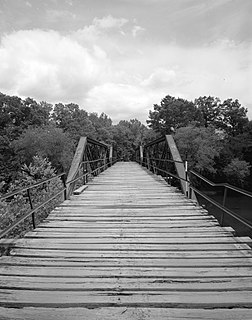
Watson Mill Bridge State Park is a 1,018-acre (4.12 km2) Georgia state park located near Comer and Carlton on the South Fork of the Broad River. The park is named for the Watson Mill Bridge the longest original-site covered bridge in Georgia, which spans 229 feet (70 m) across the South Fork of the Broad River. The site is listed on the National Register of Historic Places as the Watson Mill Covered Bridge and Mill Historic District. The bridge, built in 1885, is supported by a Town lattice truss system held together with wooden pegs also known as trunnels. Georgia once had over 200 covered bridges, but only 20 now remain. The park also offers a scenic nature trail and a new hiking/riding trail that winds through the thick forests and along the rivers edge.

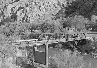
Navajo Bridge is the name of twin steel spandrel arch bridges that cross the Colorado River in the Grand Canyon National Park in northern Coconino County, Arizona, United States. The newer of the two spans carries vehicular traffic on U.S. Route 89A (US 89A) over Marble Canyon between Bitter Springs and Jacob Lake, allowing travel into a remote Arizona Strip region north of the Colorado River including the North Rim of Grand Canyon National Park.
The Wisconsin Bridge and Iron Company (WB&I) was a fabricator and erector of iron and steel bridges and other large structures.

The Floor of the Valley Road, also known as the Zion Canyon Scenic Drive, follows the canyon of the North Fork of the Virgin River, also known as Zion Canyon, through Zion National Park, Utah, USA. A precursor to the present nine-mile road was first built in 1916, but was later redesigned by the National Park Service Branch of Plans and Designs to highlight the natural features of the valley while presenting a natural-appearing built environment. The road begins at the south boundary of the park and ends at the Temple of Sinawava.

The Zion – Mount Carmel Highway is a 25-mile (40 km) long road in Washington and Kane counties in southern Utah, United States, that is listed on the National Register of Historic Places and is a National Historic Civil Engineering Landmark.

The historical buildings and structures of Zion National Park represent a variety of buildings, interpretive structures, signs and infrastructure associated with the National Park Service's operations in Zion National Park, Utah. Structures vary in size and scale from the Zion Lodge to road culverts and curbs, nearly all of which were designed using native materials and regional construction techniques in an adapted version of the National Park Service Rustic style. A number of the larger structures were designed by Gilbert Stanley Underwood, while many of the smaller structures were designed or coordinated with the National Park Service Branch of Plans and Designs. The bulk of the historic structures date to the 1920s and 1930s. Most of the structures of the 1930s were built using Civilian Conservation Corps labor.
The ERT Bridge over Blacks Fork near Fort Bridger, Wyoming, was listed on the National Register of Historic Places in 1985 as part of a thematic study on early 20th century steel truss bridges in Wyoming. The ERT Bridge is a Warren pony truss bridge spanning 80 feet (24 m) with a width of 15.75 feet (4.80 m). Set on concrete abutments, the ERT Bridge was built around 1920 by Uinta County. It is an example of a transitional design from locally built bridges to standardized State designs

The North Fork Bridge carries Arkansas Highway 5 over the North Fork River, or the North Fork of the White River, in Norfork, Arkansas, United States. It is a modern steel girder bridge, replacing a 1937 Warren deck truss bridge, which was the first road crossing of the North Fork River in Norfork. The 1937 bridge, demolished in 2014, was listed on the U.S. National Register of Historic Places in 1990, but was delisted in 2015.

The Cameron Suspension Bridge crosses the Little Colorado River at Cameron, Arizona, United States.

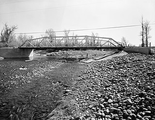
The AJX Bridge is a historic Pratt truss bridge in southwestern Johnson County, Wyoming. The bridge was built in 1931 across the South Fork of the Powder River near Kaycee, Wyoming. AJX Bridge was built to provide a river crossing for U.S. Route 87. It was placed on the National Register of Historic Places in 1985 as part of a Multiple Property Submission devoted to historic bridges in Wyoming.
Harry Langley was an architect of the National Park Service. He was born in England. He retired in 1957.
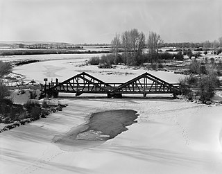
The DDZ Bridge over New Fork River is a Kingpost pony truss bridge located near Boulder, Wyoming, which carries Sublette County Road 136 across the New Fork River. The bridge was built in 1917 by Lincoln County's government, as Sublette County had not yet been formed. Unlike most truss bridges at the time, the bridge was built with timber trusses rather than steel; it is the only wooden two-span Kingpost truss bridge remaining in Wyoming. The bridge's construction is considered to be "the most sophisticated" of extant wooden truss bridges in the state.
Clarkton Bridge was a historic Pratt truss bridge located over the Staunton River near Nathalie, in Charlotte County, Virginia. It was built in 1902 by the Virginia Bridge & Iron Co., and was the only remaining metal truss structure in Virginia built for highway purposes, which was supported by steel cylinder piers. It consisted of two camelback, pin-connected steel through truss channel spans, and twelve steel deck beam approach spans. The overall dimensions of the bridge approach and truss spans were as follows: north approach, 370 feet (110 m) with twelve deck spans; north truss, 150 feet (46 m); south truss, 150 feet (46 m). The total length of the bridge was 692 feet (211 m).
The Hurricane-La Verkin Bridge spans the Virgin River, connecting the towns of Hurricane and LaVerkin in southern Utah, United States.
The Mountain Fork Bridge is a historic bridge in rural Polk County, Arkansas. It carries County Road 38 across Mountain Fork Creek north of Hatfield and southwest of Mena. The bridge consists of two spans of steel Pratt pony trusses, with a total length of 406 feet (124 m), including approach spans. The trusses are set on piers consisting of steel rings filled with concrete; each of these spans is 80 feet (24 m) long. The bridge's construction date and builder are unknown; it predates the standardization of bridge designs in the state in 1923. It is estimated to date to the early 1900s.

The South Fork Bridge is a historic bridge spanning the South Fork Ouachita River in Fountain Lake, Arkansas. It formerly carried Arkansas Highway 128, whose modern bridge now stands just to the south, a short way east of its junction with Arkansas Highway 5. It is a two-span concrete closed-spandrel arch structure, with spans of 57 feet (17 m) and a roadway width of 16 feet (4.9 m). It was built in 1928 by a county crew, after major flooding in 1927 damaged road infrastructure in the area.

The San Rafael Bridge is a historic suspension bridge over the San Rafael River in central Emery County, Utah, United States, that is listed on the National Register of Historic Places (NRHP).

The Middle Fork of the Little Red River Bridge, also known as the Shirley Railroad Bridge, is a historic bridge in Shirley, Arkansas. It is a single-span iron Baltimore through truss, with a main span 153 feet (47 m) long, and steel beam approach spans giving it a total length of 339 feet (103 m). The main span rests on large concrete piers set in the river. The bridge was built in 1908 for the Missouri and North Arkansas Railroad, and carried the railroad until 1949. In 1978 the tracks were covered by a concrete deck, and the bridge was converted to single-lane vehicular road use, carrying County Road 125.

The Hassayampa Bridge is a bridge spanning the Hassayampa River in Hassayampa, Arizona, located in Maricopa County. The bridge was completed in 1929 and was listed on the National Register of Historic Places in 1988. The bridge was scheduled for demolition in 1983.

The Jeffersonville Bridge is a steel girder bridge carrying Vermont Route 108 across the Lamoille River, just north of the village of Jeffersonville, Vermont. It was built in 2014, replacing a Parker through truss bridge built in 1931; the latter bridge was listed on the National Register of Historic Places in 1991.


