Lameroo is a town in the Murray Mallee region of South Australia. It is on the Mallee Highway and Pinnaroo railway line about 40 km west of the Victorian border, or 210 km east of Adelaide. It is primarily a service town for the surrounding rural areas, growing grain and sheep. Lameroo now includes the former settlements of Kulkami, Mulpata, Wirha and Gurrai, which were on the Peebinga railway line, and Wilkawatt, which was between Parrakie and Lameroo on the Pinnaroo railway.
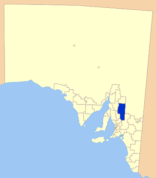
The Regional Council of Goyder is a local government area located in the Mid North region of South Australia. The council area is reliant on agriculture as a mainstay of its economy, with manufacturing and tourism also becoming prominent. The council seat is at Burra. A branch office is at Eudunda.
Port Gawler is a locality and former port on Gulf St Vincent on the central Adelaide Plains in South Australia. Port Gawler is located 43 kilometres (27 mi) north west of Adelaide in the Adelaide Plains Council local government area at the mouth of the Gawler River.

Worlds End is a locality 18 km southeast of Burra in South Australia. It also includes the area formerly known as Lapford.

Bundey is a locality in the Mid North region of South Australia. It is located on Goyder's Line, on the plains between Burra and Morgan in the Regional Council of Goyder. The bounded locality of Bundey corresponds to the boundaries of the cadastral Hundred of Bundey, except for the southwestern corner of the Hundred which is the northeastern corner of the locality of Geranium Plains. Bundey was named in 1878 for politician William Henry Bundey.

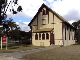
Geranium Plains is a small town in the Regional Council of Goyder in South Australia. The post office opened in 1894, but has since closed. There was a proposal to rename it to Iperta in 1916, but this did not go ahead.
Hallelujah Hills is a rural locality in the Mid North region of South Australia, situated in the Regional Council of Goyder.
Apoinga is a rural locality in the Mid North region of South Australia, situated in the Regional Council of Goyder.

Calomba is a rural locality in South Australia, situated in the Adelaide Plains Council. The formal boundaries were established in 1997 for the long established local name. The place name is supposed to have come from Trigonella suavissima, a native plant also known as calomba.

Long Plains is a rural locality and small township on the northern Adelaide Plains in South Australia, 73 km north of Adelaide. It is divided between the Wakefield Regional Council and the Adelaide Plains Council. The formal boundaries were established in 1997 for the long established local name with respect of the section in the Adelaide Plains Council; the portion in the Wakefield Council was added in January 2000.
Baldina is a rural locality in the Mid North region of South Australia, situated in the Regional Council of Goyder. It was established in August 2000, when boundaries were formalised for the "long established local name".
Emu Downs is a rural locality in the Mid North region of South Australia, situated in the Regional Council of Goyder.
Ngapala is a rural locality in the Mid North region of South Australia, situated in the Regional Council of Goyder. It was established in August 2000, when boundaries were formalised for the "long established local name". It is divided between the cadastral Hundreds of English and Julia Creek.
Bright is a rural locality in the Mid North region of South Australia, situated in the Regional Council of Goyder. It was established in August 2000, when boundaries were formalised for the "long established local name". It incorporates most of the cadastral Hundred of Bright, which was proclaimed on 17 June 1875 and named for politician Henry Edward Bright.
Koonoona is a rural locality in the Mid North region of South Australia, situated in the Regional Council of Goyder. It was established in August 2000, when boundaries were formalised for the "long established local name". It occupies the north-western corner of the cadastral Hundred of Apoinga.
Brady Creek is a rural locality in the Mid North region of South Australia, situated in the Regional Council of Goyder. It was established in August 2000, when boundaries were formalised for the "long established local name" for the creek which it is centred on and named after. It is divided between the cadastral Hundreds of Apoinga and English.
Buchanan is a rural locality in the Mid North region of South Australia, situated in the Regional Council of Goyder. It was established in August 2000, when boundaries were formalised for the "long established local name".
Peep Hill is a rural locality in the Mid North region of South Australia, situated in the Regional Council of Goyder. It was established in August 2000, when boundaries were formalised for the "long established local name". It is reported to be named for "a round hill in the last range towards the east".
Frankton is a rural locality in the Mid North region of South Australia, situated in the Regional Council of Goyder and Mid Murray Council. The section within the Goyder council was established in August 2000, when boundaries were formalised for the "long established local name"; the section within the Mid Murray council was added in March 2003. It is believed to be named after the son of two early residents, Mr. and Mrs. Rice.
The Hundred of English is a cadastral unit of hundred containing all or part of the localities of Brady Creek, Robertstown, Rocky Plain, Geranium Plains, Ngapala, Point Pass, Australia Plains and Eudunda. It is one of the 16 hundreds of the County of Eyre. It was named in 1866 by Governor of South Australia, Dominick Daly after T English MLC (1820–1884), a former mayor of Adelaide and current Member of the colony's Legislative Council at the time.
