
Aroostook County is a county in the U.S. state of Maine along the Canada–U.S. border. As of the 2010 census, the population was 71,870. Its seat is Houlton with offices in Caribou and Fort Kent.
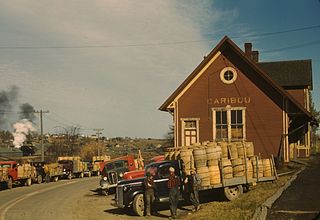
Caribou is the second largest city in Aroostook County, Maine, United States. Its population was 8,189 at the 2010 census. The city is a service center for the agricultural and tourism industries, and the location of a National Weather Service Forecast Office.

Macwahoc Plantation is a plantation in Aroostook County, Maine, United States. The population was 79 at the 2010 census.

Presque Isle is the commercial center and largest city in Aroostook County, Maine, United States. The population was 9,007 in 2019 as estimated by the US Census, a decrease from the count of 9,692 in the 2010 Census. The city is home to the University of Maine at Presque Isle, Northern Maine Community College, Husson University Presque Isle, Northern Maine Fairgrounds, The Aroostook Centre Mall, and the Presque Isle International Airport.
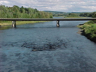
The Aroostook River is a 112-mile-long (180 km) tributary of the Saint John River in the U.S. state of Maine and the Canadian province of New Brunswick. Its basin is the largest sub-drainage of the Saint John River.
The Maine Highlands is a term used in the Maine tourism industry for a centrally located region that constitutes a large portion of the state of Maine. The Highlands are made up of Piscataquis and Penobscot counties. Formerly known as the Penquis region, the Maine Highlands name was adopted in the late 1990s to better describe the area as a tourism region.

The Bangor and Aroostook Railroad was a United States railroad company that brought rail service to Aroostook County in northern Maine. Brightly painted BAR box cars attracted national attention in the 1950s. First-generation diesel locomotives operated on BAR until they were museum pieces. The economic downturn of the 1980s coupled with the departure of heavy industry from northern Maine forced the railroad to seek a buyer and end operations in 2003.

Aroostook is a Canadian village in Victoria County, New Brunswick.
In the U.S. state of Maine, U.S. Route 2 (US 2) is a principal east–west route through the central portion of the state, extending from the New Hampshire border in Gilead to the town of Houlton near the Canadian border.

USS Aroostook (ID-1256/CM-3/AK-44) was the Eastern Steamship Company's Bunker Hill converted for planting the World War I North Sea Mine Barrage. Bunker Hill was built in 1907 at Philadelphia, Pennsylvania for passenger service between Boston and New York City. Bunker Hill and her sister ship Massachusetts were among the eight ships acquired by the U.S. Navy in November 1917. The two coastal passenger steamers were converted to minelayers at the Boston Navy Yard.

The Big Black River is a river crossing the administrative region of Chaudière-Appalaches in Quebec and in Maine. From its source, in L'Islet RCM, Quebec, the river runs northeast and east across the Canada–United States border in Maine Township 14, Range 16, WELS, to the Saint John River in Northwest Aroostook T 15, R 13.
The North Branch Meduxnekeag River is a river in Aroostook County, Maine and Carleton County, New Brunswick. From the outlet of a small pond in Maine Township 8, Range 3, WELS, the river runs about 20 miles (30 km) northeast, south, and east to the Canada–United States border, crossing into Canada at 46°16′40″N67°46′56″W. It runs about 4 miles (6 km) southeast to its confluence with the Meduxnekeag River in Wakefield, NB.

Watson Settlement Bridge is a historic covered bridge in eastern Littleton, Maine, United States. Built in 1911, it is one of the youngest of Maine's few surviving covered bridges. It formerly carried Framingham Road over the Meduxnekeag River, but is now closed to traffic, the road passing over a modern bridge to its south. It was listed on the National Register of Historic Places in 1970.

Fort Fairfield is a town in Aroostook County, eastern Maine, United States, located along the Canada–US border. The population was 3,496 at the 2010 census.

The Four Falls Border Crossing is a one-way crossing between Fort Fairfield, Maine and Four Falls, New Brunswick on the Canada–US border. Traffic is seasonally permitted to enter Canada at this location, but people entering the United States face arrest per immigration and customs laws.

The Fort Fairfield - Andover Border Crossing is an international border crossing between the towns of Fort Fairfield, Maine, United States, and Perth-Andover, New Brunswick, Canada on the Canada–US border, joining Maine State Route 161 and New Brunswick Route 190. The United States border station was built in 1933, and was listed on the National Register of Historic Places in 2014. The Canada border station was built in 2007, replacing the previous facility that was built in 1954. This crossing was a historical flashpoint during the bloodless Aroostook War of the 1830s, in which the US and Great Britain disputed the border's location. That dispute was ended with the Webster-Ashburton Treaty in 1842.
The River Pocwock is a tributary of the Saint John River, flowing in:
The Depot River is a tributary of the Big Black River, flowing in the townships T12 R17 Wels, T13 R16 Wels and T14 R15 Wels, in the Aroostook County in North Maine Woods in Maine, in United States.
The Gobeil River is a tributary of the Big Black River, flowing through:
The West Branch Pocwock Stream is a tributary of the Pocwock River flowing in:


