The Charleston Metropolitan Statistical Area, as defined by the United States Census Bureau, is an area consisting of three counties in West Virginia, anchored by the city of Charleston. It is the largest metropolitan area entirely within the state of West Virginia. While the Huntington Metro Area is more populous, it spans three states, and the core county of the Charleston area, Kanawha County, is more populous than the West Virginia portion of the Huntington area.

The Athens-Clarke County Metropolitan Statistical Area, as defined by the United States Census Bureau, is an area consisting of four counties - Clarke, Madison, Oconee, and Oglethorpe - in northeastern Georgia, anchored by the city of Athens. As of the 2020 census, the MSA had a population of 215,479.

The Brunswick metropolitan area is the Coastal Georgian metropolitan statistical area centered on the principal city of Brunswick, Georgia. The U.S. Office of Management and Budget, Census Bureau and other entities define Brunswick's metropolitan statistical area as comprising Glynn, Brantley, and McIntosh counties, including the cities of Brunswick and Darien. According to the 2020 census, the metropolitan area had a population of 113,495.

The Fayetteville, NC Metropolitan Statistical Area, as defined by the US Office of Management and Budget (OMB), is an area consisting of three counties – Cumberland, Harnett, and Hoke – in eastern North Carolina, anchored by the city of Fayetteville. It is served by Interstate 95, Interstate 295, U.S. and state highways, Fayetteville Regional Airport, Amtrak, Greyhound, Megabus and several railroad systems. As of the 2000 census, the MSA had a population of 336,609. As of the 2010 census the MSA had a population of 366,383. In 2011 the estimated population was 374,157. The 2019 estimated population is 526,719.
The Point Pleasant Micropolitan Statistical Area, as defined by the United States Census Bureau, is an area consisting of two counties – one in West Virginia and one in Ohio – anchored by the city of Point Pleasant, West Virginia.

The Parkersburg–Vienna metropolitan area, officially the Parkersburg–Vienna, WV Metropolitan Statistical Area as defined by the United States Census Bureau, is an area consisting of two counties in West Virginia, anchored by the cities of Parkersburg and Vienna. As of the 2020 census, the MSA had a population of 89,490. Prior to the 2020 census, the metro area included the city of Marietta, Ohio and Washington County, which has since been redefined as its own micropolitan area. They now form the Parkersburg–Marietta–Vienna, WV–OH Combined Statistical Area.

The Anchorage Metropolitan Statistical Area, as defined by the United States Census Bureau, is an area consisting of the Municipality of Anchorage and the Matanuska-Susitna Borough in the south central region of Alaska.

The Grand Island metropolitan area, as defined by the United States Census Bureau, is an area consisting of four counties in Nebraska, anchored by the city of Grand Island. It was upgraded from a micropolitan area and Hamilton County was added in 2012 when Grand Island's population surpassed 50,000.

The Kearney Micropolitan Statistical Area, as defined by the United States Census Bureau, is an area consisting of two counties in Nebraska, anchored by the city of Kearney.

The Rockford Metropolitan Statistical Area, as defined by the United States Census Bureau, is an area consisting of four counties in north-central Illinois, anchored by the city of Rockford. As of the 2010 census, the MSA had a population of 349,431. The Rockford MSA abuts the southern portions of the Janesville-Beloit MSA and the Chicago MSA. It forms the main part of the larger Rockford–Freeport–Rochelle Combined Statistical Area.

The Idaho Falls Metropolitan Statistical Area, as defined by the United States Census Bureau, is an area consisting of two counties in eastern Idaho, anchored by the city of Idaho Falls. As of the 2020 census, the MSA had a population of 154,855. It is just north of the Pocatello, Idaho Metropolitan Area.

The Topeka Metropolitan Statistical Area, as defined by the United States Census Bureau, is an area consisting of five counties in northeastern Kansas, anchored by the city of Topeka. In total, it has an area of 3,290.15 square miles. As of the 2010 census, the MSA had a population of 233,870.

The Manhattan–Junction City Combined Statistical Area, as defined by the United States Census Bureau, is an area consisting of three counties in northeastern Kansas, anchored by the city of Manhattan. It was upgraded from a Micropolitan Statistical Area (μSA) to a Metropolitan Statistical Area (MSA) by the Office of Management and Budget on November 20, 2008. It was changed from a Metropolitan Statistical Area (MSA) to a Combined Statistical Area (CSA) by the Office of Management and Budget on February 28, 2013.

The Montgomery, Alabama Metropolitan Statistical Area is a metropolitan area in central Alabama. As of 2020, the MSA had a population of 386,047, ranking it 142nd among United States Metropolitan Statistical Areas. That number is up +3.07% from the 2010 census number of 374,536. In September of 2018 the OMB formed the Montgomery-Selma-Alexander City CSA. It's made up of the 4 county Montgomery MSA and the Selma, AL and Alexander City, AL micropolitan areas. The 7 county CSA has a population of 522,873 as of the 2020 census.

The Wichita, Kansas Metropolitan Statistical Area, as defined by the United States Office of Management and Budget, is an area consisting of four counties in south central Kansas, its only principal city is Wichita and its only central county is Sedgwick County. As of the 2013 American Community Survey, the MSA had a population of 637,989.

The New Bern Metropolitan Statistical Area, as defined by the United States Census Bureau, is an area consisting of three counties in the Inner Banks region of eastern North Carolina, anchored by the city of New Bern. The designation of the area was changed from Micropolitan to Metropolitan in 2013.

The Iowa City Metropolitan Statistical Area, as defined by the United States Census Bureau, is an area consisting of two counties in Iowa anchored by the city of Iowa City. The Metropolitan Statistical Area (MSA) had a population of 171,491 people in the 2017 US Census Bureau population estimate. growing 12.39% compared to 2010.

The Helena Micropolitan Statistical Area, as defined by the United States Census Bureau, is an area consisting of two counties in western Montana, anchored by the city of Helena.
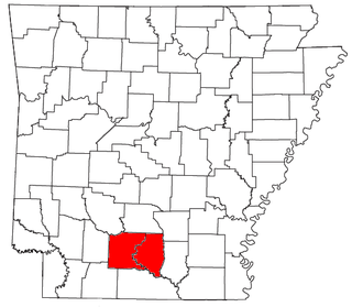
The Camden Micropolitan Statistical Area, as defined by the United States Census Bureau, is an area consisting of two counties in the U.S. state of Arkansas, anchored by the city of Camden.

The Emporia Micropolitan Statistical Area, as defined by the United States Census Bureau, is an area consisting of two counties in Kansas, anchored by the city of Emporia.

