Related Research Articles

Santa Ana is a city in and the county seat of Orange County, California, United States. Located in the Greater Los Angeles region of Southern California, the city's population was 310,227 at the 2020 census, making Santa Ana the second most populous city in Orange County, the 13th-most populous city in California, and the 64th densest large city in the United States. Santa Ana is a major regional economic and cultural hub for the Orange Coast.

Los Angeles County, officially the County of Los Angeles, and sometimes abbreviated as L.A. County, is the most populous county in the United States, with 9,861,224 residents estimated in 2022. Its population is greater than that of 40 individual U.S. states. Comprising 88 incorporated cities and many unincorporated areas within a total area of 4,083 square miles (10,570 km2), it is home to more than a quarter of Californians and is one of the most ethnically diverse U.S. counties. The county's seat, Los Angeles, is the second most populous city in the United States and the most populous city in California, with 3,822,238 residents estimated in 2022. It is also known for being the home of the American film and television industry, a distinction it has held since the early 20th century which has given the county global prominence.

Duarte is a city in Los Angeles County, California, United States. As of the 2020 census, the city population was 21,727. It is bounded to the north by the San Gabriel Mountains, to the north and west by the cities of Bradbury and Monrovia, to the south by the city of Irwindale, and to the east by the cities of Irwindale and Azusa. Duarte is located on historic U.S. Route 66 which today follows Huntington Drive through the middle of the city. The town is named after Andrés Avelino Duarte, a California ranchero who founded the community.

El Monte is a city in Los Angeles County, California, United States. The city lies in the San Gabriel Valley, east of the city of Los Angeles.

La Puente is a city in Los Angeles County, California, United States. The city had a population of 39,816 at the 2010 census and is approximately 20 miles (32 km) east of downtown Los Angeles.

San Gabriel is a city located in the San Gabriel Valley of Los Angeles County, California. At the 2010 census, the population was 39,718.

West Whittier-Los Nietos is a census-designated place (CDP) in Los Angeles County, California, near the San Gabriel River and the San Gabriel River (I-605) Freeway. The population was 25,540 at the 2010 census, up from 25,129 at the 2000 census. The census area consists of separate unincorporated communities of Los Nietos and West Whittier.

Aliso Viejo is a city in the San Joaquin Hills of southern Orange County, California. It had a population of 52,176 as of the 2020 census, up from 47,823 as of the 2010 census. It became Orange County's 34th city on July 1, 2001, the only city in Orange County to be incorporated since 2000. It is bordered by the cities of Laguna Beach on the west and southwest, Laguna Hills on the east, Laguna Niguel on the southeast, and Laguna Woods on the north. It is similarly named to another nearby city, Mission Viejo.

Rancho Santa Margarita is a city in Orange County, California, United States. One of Orange County's youngest cities, Rancho Santa Margarita is a master-planned community. The population was 47,853 at the 2010 census, up from 47,214 at the 2000 census. Although it is named for Rancho Santa Margarita y Las Flores, which was in San Diego County, the city limits fall within the borders of Rancho Mission Viejo. At 20 characters long, it is the longest city name in California.
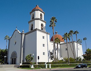
San Juan Capistrano is a city in southern Orange County, California, United States. The population was 35,253 at the 2020 Census.

Wilmington is a neighborhood in the South Bay and Harbor region of Los Angeles, California, covering 9.14 square miles (23.7 km2).

The Las Flores Estancia was established in 1823 as an estancia ("station"). It was part of the Spanish missions, asistencias, and estancias system in Las Californias—Alta California. Las Flores Estancia was situated approximately halfway between Mission San Luis Rey de Francia and Mission San Juan Capistrano. It is located near Bell Canyon on the Camp Pendleton Marine Corps Base ten miles south of the City of San Clemente in northern San Diego County, California. The estancia is also home to the architecturally significant National Historic Landmark Las Flores Adobe, completed in 1868.
Los Angeles Township was a defunct township in Los Angeles County, California. It existed prior to the abolition of townships in California in the 1870s. Los Angeles Township consisted of areas surrounding the original city lands of Los Angeles, then a four-league square bordered by Hoover Street, Fountain Avenue, Indiana Street and Exposition Boulevard. These included the San Fernando Valley and present-day West Los Angeles and East Los Angeles. Most of this area has now been annexed to the city of Los Angeles, but a few portions exist as independent cities, including Glendale, Burbank and Santa Monica.
Rancho Pauba was a 26,598-acre (107.64 km2) Mexican land grant in present-day Riverside County, California given in 1844 by Governor Manuel Micheltorena to Vicente Moraga and Luis Arenas. The grant was just east of present-day Temecula. At the time of the US patent, Rancho Pauba was a part of San Diego County. Riverside County was created by the California Legislature in 1893 by taking land from both San Bernardino and San Diego Counties.
Rancho Niguel was a 13,316-acre (53.89 km2) Mexican land grant in the San Joaquin Hills, within present-day Orange County, California.
Rancho Boca de la Playa was a 6,607-acre (26.74 km2) Mexican land grant in present-day Orange County, California given in 1846 by Governor Pío Pico to Emigdio Véjar. The name refers to the wetlands estuary at the 'mouth of the beach,' or 'boca de la playa' in Spanish. This is the most southerly grant in Orange County, and extended along the Pacific coast from San Juan Creek in the south of present-day San Juan Capistrano south to San Clemente.
San Jose Township was a township in Los Angeles County, California. It existed prior to the abolition of townships in California, and appeared as a subdivision of Los Angeles County in the 1860, 1870 and 1880 U.S. Censuses. Its area encompassed Rancho San Jose, the eastern portions of the county drained by San Jose Creek, including what is now the cities of Pomona, Claremont and Walnut. In 1880, it was recorded as having 1170 residents - which made it one of the smallest townships in Los Angeles County, but nevertheless a sizable settlement in the region, larger than Bakersfield and slightly smaller than Riverside
Tejon Township was a defunct township in Los Angeles County, California. It existed prior to the abolition of townships in California in the 1870s. By far the largest of the county's townships, it encompassed an area from the San Gabriel and Santa Susana Mountains in the south to the Tulare County line in the north. It was centered on Fort Tejon. In 1860, the township had a population of 920.
Soledad Township was a defunct township in Los Angeles County, California. It existed prior to the abolition of townships in California. It was formed in 1866 when Tejon Township was divided between Los Angeles and the new Kern County. Soledad Township was the county's most extensive but least populated township. It stretched from the San Gabriel and Santa Susana Mountains to the Kern County line and was centered on Soledad Canyon. In 1870, the township had a population of 265.

Acjacheme was an Acjachemen village that was closely situated to the mother village of Putuidem in what is now San Juan Capistrano, California. The Spanish missionaries constructed Mission San Juan Capistrano less than 60 yards from the village in 1776. Acjachemen is a pluralization of the word Acjacheme, and became the moniker for the people overall after the mission period.
References
- ↑ Paul R. Spitzzeri (Fall 2007). "What a Difference a Decade Makes: Ethnic and Racial Demographic Change in Los Angeles County during the 1860s" (PDF). Branding Iron.
- ↑ U.S. Census Bureau. "Population of the United States in 1860: California" (PDF).
