
Tesuque is a census-designated place (CDP) in Santa Fe County, New Mexico, United States. It is part of the Santa Fe, New Mexico, Metropolitan Statistical Area. The population was 909 at the 2000 census. The area is separate from but located near Tesuque Pueblo, a member of the Eight Northern Pueblos, and the Pueblo people are from the Tewa ethnic group of Native Americans who speak the Tewa language. The pueblo was listed as a historic district on the National Register of Historic Places in 1973.

The Santa Fe Trail was a 19th-century route through central North America that connected Franklin, Missouri, with Santa Fe, New Mexico. Pioneered in 1821 by William Becknell, who departed from the Boonslick region along the Missouri River, the trail served as a vital commercial highway until 1880, when the railroad arrived in Santa Fe. Santa Fe was near the end of El Camino Real de Tierra Adentro, which carried trade from Mexico City.

Fort Union National Monument is a unit of the National Park Service of the United States, and is located north of Watrous in Mora County, New Mexico. The national monument was founded on June 28, 1954.

Ratón Pass is a 7,834 ft (2,388 m) elevation mountain pass on the Colorado–New Mexico border in the western United States. It is located on the eastern side of the Sangre de Cristo Mountains between Trinidad, Colorado and Raton, New Mexico, approximately 180 miles (290 km) northeast of Santa Fe. Ratón is Spanish for "mouse". The pass crosses the line of volcanic mesas that extends east from the Sangre de Cristo Mountains along the state line, and furnishes the most direct land route between the valley of the Arkansas River to the north and the upper valley of the Canadian River, leading toward Santa Fe, to the south. The pass now carries Interstate 25 and railroad tracks.

The Salinas Pueblo Missions National Monument is a complex of three Spanish missions located in the U.S. state of New Mexico, near Mountainair. The main park visitor center is in Mountainair. Construction of the missions began in 1622 and was completed in 1635.

This is a list of properties and districts in New Mexico that are on the National Register of Historic Places. There are more than 1,100 listings. Of these, 46 are National Historic Landmarks. There are listings in each of the state's 33 counties.

The Palace of the Governors is an adobe structure built in the Territorial Style of Pueblo architecture on Palace Avenue in Santa Fe, New Mexico. Located within the Santa Fe Historic District along the Santa Fe Plaza between Lincoln and Washington avenues, it has served as the seat of government for New Mexico for centuries, having been established as the capitol building of Nuevo México in 1610.

The historic U.S. Route 66 ran east–west across the central part of the state of New Mexico, along the path now taken by Interstate 40 (I-40). However, until 1937, it took a longer route via Los Lunas, Albuquerque, and Santa Fe, now roughly New Mexico State Road 6 (NM 6), I-25, and US 84. Large portions of the old road parallel to I-40 have been designated NM 117, NM 118, NM 122, NM 124, NM 333, three separate loops of I-40 Business, and state-maintained frontage roads.

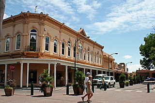
The Santa Fe Plaza is a National Historic Landmark in downtown Santa Fe, New Mexico in the style of traditional Spanish-American colonial cities. The plaza, or city square, was originally, and is still to this day, the center gathering place in town. Many know it as "the heart of Santa Fe". The landmark has since grown into a playground for many tourists interested in Spanish, Native American, and Mexican cultures, and includes music, design, jewelry, art and dance. It is home to annual events including Fiestas de Santa Fe, the Spanish Market, the Santa Fe Bandstand, and the Santa Fe Indian Market.

El Rancho de las Golondrinas, a historic rancho and now a living history museum, is strategically located on what was once the Camino Real, the Royal Road that extended from Mexico City to Santa Fe. The ranch provided goods for trade and was a place where the caravans that plied the road would stop on their journey coming from or going to Santa Fe. It was a paraje, an official rest stop for travelers, and was even mentioned by the great colonial military leader and governor, Don Juan Bautista de Anza, when he stopped here with his expeditionary force in 1780.
The Don Gaspar Historic District is a historic district in Santa Fe, New Mexico. It was listed on the National Register of Historic Places in 1983. The listing included 278 contributing buildings.

The Barrio de Analco Historic District is a National Historic Landmark District centered at the junction of East De Vargas Street and Old Santa Fe Trail in Santa Fe, New Mexico. The seven buildings of the district represent one of the oldest clusters of what were basically working-class or lower-class residences in North America, and are in a cross-section of pre-statehood architectural styles. It includes two of the oldest colonial-era buildings in the southwest, the San Miguel Mission church (1710), and the "Oldest House", built in 1620 and now a museum. The district was declared a National Historic Landmark in 1968.

Watrous, also named La Junta, is a National Historic Landmark District near Watrous, New Mexico. It encompasses the historic junction point of the two major branches of the Santa Fe Trail, a major 19th-century frontier settlement route between St. Louis, Missouri and Santa Fe, New Mexico. La Junta, marked this junction point, as well as the first major indications of civilization before westbound travelers reached Santa Fe. The district includes a large area west of the modern community of Watrous, encompassing the confluence of the Mora and Sapello Rivers. Surviving buildings include the houses of early ranchers, as well as a stagecoach mailstop and inn. The district was designated a National Historic Landmark in 1963.

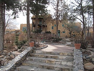
Seton Village is a National Historic Landmark District in a rural residential area south of Santa Fe in Santa Fe County, New Mexico, United States. It encompasses a residential settlement and educational facility established in 1930 by Ernest Thompson Seton (1860-1946), an educator and conservationist best known as a founder of the Boy Scouts of America. The district includes the remains of Seton's 32-room home and other residential and educational buildings constructed mostly between 1930 and 1945. It was declared a National Historic Landmark in 1965.

The Donaciano Vigil House is an adobe house built in 1832 in Santa Fe, New Mexico. It was listed on the National Register of Historic Places in 1972. It was home of Donaciano Vigil, the first Hispanic governor of New Mexico.
Santa Fe is the capital of the U.S. state of New Mexico. With a population of 87,505 as of the 2020 census, it is the fourth-largest city in New Mexico. It is also the county seat of Santa Fe County. Its metropolitan area is part of the Albuquerque–Santa Fe–Las Vegas combined statistical area, which had a population of 1,162,523 in 2020. The city was founded in 1610 as the capital of Nuevo México, replacing the previous capital, San Juan de los Caballeros at San Gabriel de Yungue-Ouinge, which makes it the oldest state capital in the United States. It is also at the highest altitude of any of the U.S. state capitals, with an elevation of 7,199 feet.
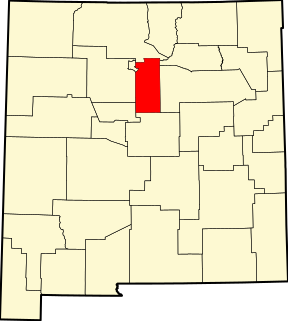
This is a list of the National Register of Historic Places listings in Santa Fe County, New Mexico.

Northern Rio Grande National Heritage Area is a federally designated National Heritage Area in the U.S. state of New Mexico. The national heritage area includes a section of the upper Rio Grande Valley that has been inhabited by the Puebloan peoples since the early Pre-Columbian era.
Cañoncito is an unincorporated community in Santa Fe County, New Mexico, United States. Cañoncito is located on Interstate 25, 11.5 miles (18.5 km) southeast of Santa Fe. Nuestra Señora de Luz Church and Cemetery, which is listed on the National Register of Historic Places, is located in Cañoncito.

La Cueva Historic District, in Mora County, New Mexico near Mora, New Mexico, is a historic district which was listed on the National Register of Historic Places in 1973. The listing included five contributing buildings on 47 acres (19 ha).


