Bandelier National Monument is a 33,677-acre (136 km2) United States National Monument near Los Alamos in Sandoval and Los Alamos counties, New Mexico. The monument preserves the homes and territory of the Ancestral Puebloans of a later era in the Southwest. Most of the pueblo structures date to two eras, dating between AD 1150 and 1600.

The Santa Fe Trail was a 19th-century route through central North America that connected Franklin, Missouri, with Santa Fe, New Mexico. Pioneered in 1821 by William Becknell, who departed from the Boonslick region along the Missouri River, the trail served as a vital commercial highway until 1880, when the railroad arrived in Santa Fe. Santa Fe was near the end of El Camino Real de Tierra Adentro which carried trade from Mexico City. The trail was later incorporated into parts of the National Old Trails Road and U.S. Route 66.

El Morro National Monument is a U.S. national monument in Cibola County, New Mexico, United States. Located on an ancient east–west trail in the western part of the state, the monument preserves the remains of a large prehistoric pueblo atop a great sandstone promontory with a pool of water at its base, which subsequently became a landmark where over the centuries explorers and travelers have left personal inscriptions that survive today.
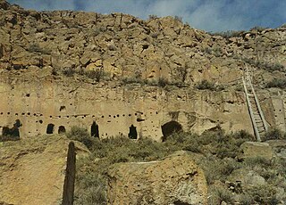
The Puye Cliff Dwellings are the ruins of an abandoned pueblo, located in Santa Clara Canyon on Santa Clara Pueblo Reservation land near Española, New Mexico. Established in the late 1200s or early 1300s and abandoned by about 1600, this is among the largest of the prehistoric Indian settlements on the Pajarito Plateau, showing a variety of architectural forms and building techniques.

The Salinas Pueblo Missions National Monument is a complex of three Spanish missions located in the U.S. state of New Mexico, near Mountainair. The main park visitor center is in Mountainair. Construction of the missions began in 1622 and was completed in 1635.

Pecos National Historical Park is a United States National Historical Park in San Miguel County, New Mexico. The park, operated by the National Park Service, encompasses thousands of acres of landscape infused with historical elements from prehistoric archaeological ruins to 19th-century ranches, to a battlefield of the American Civil War. Its largest single feature is Pecos Pueblo also known as Cicuye Pueblo, a Native American community abandoned in historic times. First a state monument in 1935, it was made Pecos National Monument in 1965, and greatly enlarged and renamed in 1990. Two sites within the park, the pueblo and the Glorieta Pass Battlefield, are National Historic Landmarks.

Old Town is the historic original town site of Albuquerque, New Mexico, for the provincial kingdom of Santa Fe de Nuevo México, established in 1706 by New Mexico governor Francisco Cuervo y Valdés. It is listed on the New Mexico State Register of Cultural Properties as the Old Albuquerque Historic District, and is protected by a special historic zoning designation by the city. However, prior to its establishment as a city in the Santa Fe de Nuevo México province, many indigenous tribes lived there including Diné, Pueblo, Apache, Tiwa, and others. The present-day district contains about ten blocks of historic adobe buildings surrounding Old Town Plaza. On the plaza's north side stands San Felipe de Neri Church, a Spanish colonial church constructed in 1793.

Las Trampas or just Trampas, is an unincorporated hamlet in Taos County, New Mexico. Founded in 1751 to settle the Las Trampas Land Grant, its center retains the original early Spanish colonial defensive layout as well as the 18th-century San José de Gracia Church, one of the finest surviving examples of Spanish colonial church architecture in the United States. The village center was designated a National Historic Landmark District in 1967. The population in 2023 was 43.

The Palace of the Governors is an adobe structure built in the Territorial Style of Pueblo architecture on Palace Avenue in Santa Fe, New Mexico. Located within the Santa Fe Historic District along the Santa Fe Plaza between Lincoln and Washington avenues, it served as the seat of government for New Mexico for centuries, having been established as the capitol building of Nuevo México in 1610. It was New Mexico's seat of government until 1901.

El Camino Real de Tierra Adentro, also known as the Silver Route, was a Spanish 2,560-kilometre-long (1,590 mi) road between Mexico City and San Juan Pueblo, New Mexico, that was used from 1598 to 1882. It was the northernmost of the four major "royal roads" that linked Mexico City to its major tributaries during and after the Spanish colonial era.

The National Park Service Southwest Regional Office, also known as National Park Service Region III Headquarters Building, is located at 1100 Old Santa Fe Trail in Santa Fe, New Mexico. The office provides support services for Park Service properties throughout the intermountain region of the American Southwest. The building, designed by NPS architect Cecil J. Doty, it is a traditional adobe building, built the 1930s by crews of the Civilian Conservation Corps. It is the largest adobe office building in the nation, and a masterpiece of Spanish Pueblo Revival architecture. It was designated a National Historic Landmark in 1987. It is open to the public during normal business hours; tours are not normally given.
The following is an alphabetical list of articles related to the U.S. state of New Mexico.

The Barrio de Analco Historic District is a National Historic Landmark District centered at the junction of East De Vargas Street and Old Santa Fe Trail in Santa Fe, New Mexico. The seven buildings of the district represent one of the oldest clusters of what were basically working-class or lower-class residences in North America, and are in a cross-section of pre-statehood architectural styles. It includes two of the oldest colonial-era buildings in the southwest, the San Miguel Mission church (1710), and the "Oldest House", built in 1620 and now a museum. The district was declared a National Historic Landmark in 1968.
Santa Fe Historic District is a historic district in Santa Fe, New Mexico that was listed on the National Register of Historic Places in 1973. It includes two sites that are individually named U.S. National Historic Landmarks:

Santa Fe is the capital of the U.S. state of New Mexico, and the county seat of Santa Fe County. With over 89,000 residents, Santa Fe is the fourth-most populous city in the state, and part of the Albuquerque–Santa Fe–Los Alamos combined statistical area, which had a population of 1,162,523 in 2020. Situated at the foothills of the Sangre de Cristo Mountains, the city is at the highest altitude of any U.S. state capital, with an elevation of 6,998 feet.

This is a list of the National Register of Historic Places listings in Santa Fe County, New Mexico.

Northern Rio Grande National Heritage Area is a federally designated National Heritage Area in the U.S. state of New Mexico. The national heritage area includes a section of the upper Rio Grande Valley that has been inhabited by the Puebloan peoples since the early Pre-Columbian era.

Taos Downtown Historic District is a historic district in Taos, New Mexico. Taos "played a major role in the development of New Mexico, under Spanish, Mexican, and American governments." It is a key historical feature of the Enchanted Circle Scenic Byway of northern New Mexico.
The Camino Real in New Mexico was the northern part of a historic roadway known as the Camino Real de Tierra Adentro that from 1598 ran from Mexico City northward through central and northern Mexico and the Trans-Pecos part of what is now Texas to San Juan Pueblo in Santa Fe de Nuevo Mexico, now the state of New Mexico.

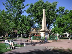
The Soldiers' Monument is a cenotaph at the center of the Santa Fe Plaza, a monument collectively memorializing deaths in several specified battles. It is obscured from public view and access by concreteboard walls used as a preservation measure. Erected during the late 1860s in the aftermath of the American Civil War, it consisted of a 33 feet (10 m) stone obelisk atop a plinth; only the plinth stands currently, and exhibits some damage. During the late nineteenth century, the monument was used as a place for Union veterans to gather at annual Memorial Day events to decorate the cenotaph and hear brief presentations.