
The Uhlerstown–Frenchtown Bridge is a free bridge over the Delaware River, owned and operated by the Delaware River Joint Toll Bridge Commission. The bridge connects New Jersey Route 12 in Frenchtown of Hunterdon County, New Jersey with Pennsylvania Route 32 in Uhlerstown of Bucks County, Pennsylvania.
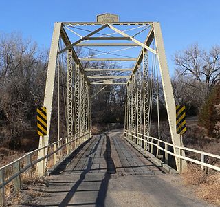
Franklin Bridge is a bridge in Franklin County, Nebraska. The road bridge was built over the Republican River in 1932 and features Warren pony trusses. In 1935, a flood swept away one truss and one approach span. The bridge was listed on the National Register of Historic Places in 1992, and was delisted in 2020.

The Lisco State Aid Bridge is located on a county road over the North Platte River south of Lisco, Nebraska. Completed in 1928, the bridge today "is distinguished as an important crossing of the Platte River and one of the last two intact multiple-span state aid truss bridges" in Nebraska.

19th Street Bridge is a two-span through Pratt truss road bridge in Denver, Colorado, over the South Platte River, now used for pedestrians. It was built in 1888 to replace a wooden structure and carried automobile traffic until 1986. The bridge is listed on the National Register of Historic Places.

The AJX Bridge is a historic Pratt truss bridge in southwestern Johnson County, Wyoming. The bridge was built in 1931 across the South Fork of the Powder River near Kaycee, Wyoming. AJX Bridge was built to provide a river crossing for U.S. Route 87. It was placed on the National Register of Historic Places in 1985 as part of a Multiple Property Submission devoted to historic bridges in Wyoming.
The Borman Bridge bringing a Cherry County, Nebraska road over the Niobrara River near Valentine, Nebraska was built in 1916, as a replacement for one of 18 Cherry County bridges washed away by flood and winter ice on February 16, 1916. It was designed by the Canton Bridge Co. of Canton, Ohio, fabricated by the Cambria Steel Co. of Johnstown, and built by the Canton Bridge Co.
The Colclesser Bridge, over the Niobrara River about 11 miles south of Rushville, Nebraska, is a bridge erected at its current location in 1933. Its span was one of four 248 foot spans in the Columbus Loup River Bridge, that was built in 1888, and that carried the Lincoln and Meridian Highways over the Loup River. It was replaced in 1933, and the span was stored apparently, because when flooding in August 1933 destroyed numerous bridges in Sheridan County, it was purchased and erected for cost of $6,211, less four panels so its current span is 166 feet.

The Albright Bridge is a historic structure located south of Webster City, Iowa, United States. It spans the Boone River for 207 feet (63 m). In April 1907 the Hamilton County Board of Supervisors contracted with A.H. Austin from Webster City to build the new bridge in Independence Township for $4,342. The Eastern Steel Company provided the steel. The Pratt through truss bridge was completed in early January 1908. The bridge was listed on the National Register of Historic Places in 1998.

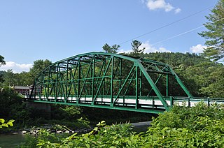
The South Street Bridge is a historic Pratt truss bridge, carrying Vermont Route 31 across the Poultney River just south of the village center of Poultney, Vermont. Built in 1923, it is one of a small number of surviving Pratt through trusses in the state, and one of just three that survives from the period before the state's devastating 1927 floods. It was listed on the National Register of Historic Places in 2009 as Bridge 4.
Bridge 15, also known locally as the River Bridge, spans the White River in Sharon, Vermont. Built in 1928, this multi-span Parker truss bridge is one of a shrinking number of White River crossings of this type. It was listed on the National Register of Historic Places in 2008.

The Bridgewater Corners Bridge carries Vermont Route 100A across the Ottauquechee River in the Bridgewater Corners village of Bridgewater, Vermont. It was built in 1928 by the American Bridge Company, following devastating flooding. It is a single-span Pratt through truss structure, and was listed on the National Register of Historic Places in 1992.

The Gould's Mill Bridge is a historic Baltimore through truss bridge, carrying Paddock Street across the Black River in Springfield, Vermont. The bridge was built by the Boston Bridge Works Company in 1929 after major flooding in 1927, and is one of the state's few examples of a Baltimore truss. It was listed on the National Register of Historic Places in 2006.

The Lincoln Covered Bridge is a historic covered bridge, just south of U.S. Route 4 in West Woodstock, Vermont. Built in 1877, it is one of the only known examples of a wooden Pratt truss bridge in the United States. It was listed on the National Register of Historic Places in 1973.

The Quechee Gorge Bridge is a historic bridge, carrying U.S. Route 4 (US 4) across Quechee Gorge, near the Quechee village of Hartford, Vermont. Built in 1911, it is Vermont's oldest surviving steel arch bridge. It was listed on the National Register of Historic Places in 1990.

The Ocean-to-Ocean Bridge is a through truss bridge spanning the Colorado River in Yuma, Arizona. Built in 1915, it was the first highway crossing of the lower Colorado and is the earliest example of a through truss bridge in Arizona. It is also the only example of a Pennsylvania truss within Arizona. Originally the bridge carried the transcontinental Ocean-to-Ocean Highway and later carried its successor, US 80 until a new bridge was built to the west in 1956. Between 1988 and 2001, the bridge was closed to vehicular traffic and only traversable by pedestrians and bicyclists. After a major restoration, the bridge was rehabilitated and reopened to vehicular traffic in 2002, with a re-dedication by the Quechan nation and Yuma Crossing National Heritage Area. The bridge became part of Historic US 80 in 2018.

Arch Street Bridge is Parker truss bridge over the Passaic River in Paterson, New Jersey. It was built in 1907 and rehabilitated in 1997. It was the third structure built at the location within a few years, the other having been destroyed by floods in 1902 and 1903. The bridge was once a crossing for the Public Service trolley lines.

The Burwell Bridge was a historic bridge on the northern edge of Burwell in Garfield County, Nebraska which was built in 1940–41. It was a steel girder bridge that brings Nebraska Highway 11 over the North Loup River. It is also known as the North Loup River Bridge and denoted as NEHBS Number GFOO-13. It was listed on the National Register of Historic Places in 1992, and was delisted in 2019.

The North Loup Bridge brings a county road over the North Loup River, about 1.5 miles northeast of the village of North Loup in Valley County, Nebraska. It was built in 1912-1913 by Empire Bridge Company of Omaha, Nebraska, at cost of $13,089, using steel parts fabricated by Cambria Steel Company and Lackawanna Steel Company. It is a Pratt through truss bridge and includes three 100 feet (30 m) through truss spans upon steel cylinder piers. There is also a 40 feet (12 m) pony truss approach span on the south side.

The Neligh Mill Bridge is a truss bridge which brings Elm St. over the Elkhorn River in Neligh in Antelope County, Nebraska. It was built in 1910 and was listed on the National Register of Historic Places in 1992. It has also been known as the Elm Street Bridge and as Elkhorn River Bridge.

The Gillespie Dam Bridge is a through truss bridge spanning the Gila River in Maricopa County, in the U.S. state of Arizona. The bridge was constructed to bypass a concrete apron through the river in front of the Gillespie Dam, which was often closed due to flooding. Construction of the bridge started in 1925 and completed in 1927. From its opening until 1956, the bridge was part of U.S. Route 80 (US 80), a transcontinental highway between San Diego, California and Tybee Island, Georgia. The bridge was restored in 2012 by Maricopa County for the Arizona Centennial and now includes an educational interpretive center for visitors. The bridge became part of Historic US 80 in 2018.


