
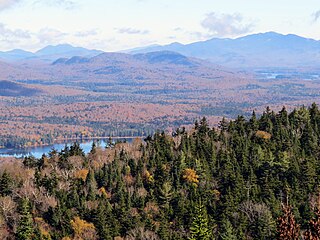
The Adirondack Mountains form a massif in northeastern New York, United States. Its boundaries correspond roughly to the boundaries of Adirondack Park. The mountains form a roughly circular dome, about 160 miles (260 km) in diameter and about 1 mile (1,600 m) high. The current relief owes much to glaciation.

Indian Lake is a town in Hamilton County, New York, United States. The population was 1,352 at the 2010 census. The name is from a lake of the same name that is largely inside the town. There are no permanent stop lights in the town. Law enforcement is provided by New York State Troopers and Hamilton County Sheriff's Office.

Long Lake is a town in Hamilton County, New York, in the United States. The population was 711 at the 2010 census.

The Adirondack Park is a part of New York's Forest Preserve in northeastern New York, United States. The park's boundary roughly corresponds with the Adirondack Mountains. Established in 1885, it was the first state preserve of its type in the nation. Unlike most preserves, about 52 percent of the land is privately owned inholdings heavily regulated by the Adirondack Park Agency. This area contains 102 towns and villages, as well as numerous farms, businesses, and an active timber harvesting industry. The year-round population is 132,000, with 200,000 seasonal residents. The inclusion of human communities makes the park one of the great experiments in conservation in the industrialized world. It was designated a National Historic Landmark in 1963.

Cascade Mountain is in Essex County of New York. It is one of the 46 Adirondack High Peaks (36th) and is located in the Adirondack Park. Its name comes from a series of waterfalls on a brook near the mountain's base. The lake it flows into and the pass between Cascade and Pitchoff mountains are also named Cascade.

The Raquette River, sometimes spelled Racquette, originates at Raquette Lake in the Adirondack Mountains in New York. 146 miles (235 km) long, it is the third longest river entirely in the state of New York.

Lake Tear of the Clouds is a small tarn located in the town of Keene, in Essex County, New York, United States, on the southwest slope of Mount Marcy, the state's highest point, in the Adirondack Mountains. It is the highest pond in the state. It is often cited as the highest source of the Hudson River, via Feldspar Brook, the Opalescent River and Calamity Brook.

Mount Jo is a 2876-foot mountain in the heart of the Adirondack Mountains of New York. It is located in North Elba, New York on land owned by the Adirondack Mountain Club. The Adirondack Loj and Heart Lake are located at the foot of Mount Jo. There are two trails that lead to its summit.
New York State Route 28N (NY 28N) is an east–west state highway in the North Country of New York in the United States. It extends for 50.95 miles (82.00 km) through the Adirondack Mountains from Blue Mountain Lake to North Creek. The route is a northerly alternate route to NY 28 between both locations; as such, it passes through several communities that NY 28 bypasses to the south. The westernmost 10 miles (16 km) of NY 28N overlap with NY 30 through the town of Long Lake. NY 28N and NY 30 split in the hamlet of Long Lake, from where NY 30 heads to the north and NY 28N proceeds eastward through mountainous regions of Adirondack Park.
MacNaughton Mountain is a mountain located in Essex County, New York, named after James MacNaughton (1851–1905), the grandson of Archibald McIntyre. The mountain is part of the Street Range of the Adirondack Mountains.

The Cedar River is a 38.5-mile-long (62.0 km) river in the central Adirondacks, in Hamilton County, New York. It rises at the outlet of Cedar Lake in the Town of Arietta and flows northeast into the Town of Lake Pleasant, where it passes through the Cedar River Flow. Continuing northeast and east, it passes through the Town of Indian Lake and remote corners of the Towns of Minerva and Newcomb to join the Hudson River northeast of the hamlet of Indian Lake. The Northville-Placid Trail goes past the Cedar Lakes and along the Cedar River to the flow.

Hadley Mountain is a mountain located in the southern Adirondacks in the U.S. state of New York and is the second highest peak in Saratoga County after neighboring Tenant Mountain. The Hadley Mountain Fire Observation Station was listed on the National Register of Historic Places on September 23, 2001 for its role as a Fire lookout tower with the New York State Forest Preserve. Hadley Mountain is the highest of the three peaks that form the West Mountain ridge.

Ampersand Mountain is a 3,352 ft (1,021.7 m) mountain in Franklin County in the northeastern Adirondacks, west of the High Peaks in New York State. The trail up the mountain begins on New York State Route 3 8.1 miles (13.0 km) southwest of the village of Saranac Lake, near Middle Saranac Lake; it is a popular day hike. The mountain takes its name from nearby Ampersand Creek, so named because it twists and turns like the ampersand symbol. The summit is bare rock, with extensive views of the High Peaks to the east and the Saranac Lakes to the west. Stony Creek Mountain is located west-southwest of Ampersand Mountain.

Blue Mountain is a peak in the Adirondack Mountains of New York State in the United States. Located east of Blue Mountain Lake, Hamilton County, the peak reaches a height of 3750 ft/1143m. For hiking, the elevation gain is 1,559 feet and the trail length is four miles. The trailhead elevation is 2,200 feet. It is the location of the Blue Mountain Fire Observation Station, listed on the National Register of Historic Places in 2001.
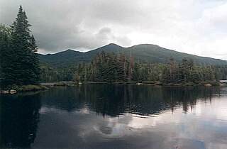
Owls Head Mountain is a 2,812-foot (857 m) mountain in Long Lake, New York in the Adirondack Park.

Spruce Mountain is a mountain in the Kayaderosseras Range in the town of Corinth in Saratoga County, New York. The 2,005 foot (611 m) summit is accessible via a 1.3-mile (2.1 km) trail and is topped with a 73 foot (22 m) fire tower affording a more than 120-mile (190 km) panoramic view from the Adirondacks to the Catskills, and east to Vermont. The tower, built in 1928 and refurbished in 2015, is one of only 23 remaining in the Adirondack Mountains.
Sacandaga Lake (sa-kuhn-DAH-ga) is a lake in the Town of Lake Pleasant in Hamilton County, New York approximately 2 miles (3.2 km) west of Speculator.The outlet is a channel that leads to Lake Pleasant, which is the source of the Sacandaga River.
The 37,800-acre Blue Mountain Wild Forest is part of the Adirondack Forest Preserve. It is made of five separate sections of acreage in the central Adirondacks. The communities of Indian Lake, Blue Mountain Lake, Long Lake, and Newcomb are located by or within the Blue Mountain Wild Forest. The terrain varies from gentle around Rock Lake to extremely steep and rugged in the Fishing Brook Range. The 3,759-foot Blue Mountain is located in the wild forest and can be seen for some distance around it. The Blue Mountain Fire Observation Station is also located within the wilderness area. The Northville-Placid Trail has a section that runs 15.2 miles through the Blue Mountain Wild Forest.
Rock Lake is located southeast of Clockmill Corners, New York. Fish species present in the lake are brown bullhead, chain pickerel, brook trout, and sunfish. There is trail access off Powley-Piseco Road along the west shore.

Kane Mountain is a mountain in the Adirondack Mountains region of New York. It is located north of the Hamlet of Canada Lake. The Kane Mountain Fire Observation Station is located on top of the mountain. Sheeley Mountain is located south-southwest, Canada Lake is located south, Camelhump is located east and Pine Lake is located north of Kane Mountain.

