Scott, New York

Last updated

Scott, New York
Glen Haven marina800.jpg
Skaneateles Lake marina, hamlet of Fair Haven
Cortland County NY Scott town highlighted.svg
Location within Cortland County and New York
Usa edcp location map.svg
Red pog.svg
Scott
Location in the United States
USA New York location map.svg
Red pog.svg
Scott
Scott (New York)
Coordinates: 42°43′46″N76°13′54″W / 42.72944°N 76.23167°W / 42.72944; -76.23167
Country United States
State New York
County Cortland
Government
  Type Town Council
   Town Supervisor Louis S. Martin (R)
   Town Council
Members' List
Area
[1]
  Total22.39 sq mi (57.99 km2)
  Land22.24 sq mi (57.61 km2)
  Water0.15 sq mi (0.38 km2)
Elevation
1,795 ft (547 m)
Population
 (2010)
  Total1,176
  Estimate 
(2016) [2]
1,139
  Density51.21/sq mi (19.77/km2)
Time zone UTC-5 (Eastern (EST))
  Summer (DST) UTC-4 (EDT)
ZIP code
13077
Area code 607
FIPS code 36-023-65915
GNIS feature ID0979477
Website www.townofscott.org

Scott is a town in Cortland County, New York, United States. The population was 1,176 at the 2010 census. [3] The town was named after General Winfield Scott. It is in the northwestern corner of Cortland County and is northwest of the City of Cortland.

Contents

History

Scott is within the former Central New York Military Tract. The first white settler arrived around 1799.

The town was formed in 1815 from the town of Preble. The population in 1865 was 1,149.

The town is the birthplace of James Henry Salisbury, who later went on to create the Salisbury Steak. [4]

Geography

Skaneateles Lake from above Glen Haven GlenHavenFiordSmaller.jpg
Skaneateles Lake from above Glen Haven

According to the United States Census Bureau, the town has a total area of 22.4 square miles (58.1 km2), of which 22.3 square miles (57.7 km2) is land and 0.15 square miles (0.4 km2), or 0.65%, is water. [3]

The western town line is the border of Cayuga County, and the northern town boundary is the border of Onondaga County. New York State Route 41 is a north-south highway in Scott.

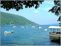
The southern end of Skaneateles Lake, one of the Finger Lakes, is in the northwestern part of the town. Grout Brook, a noted trout-fishing stream, flows into the lake from the town. The hamlet of Fair Haven in the town of Scott, together with adjoining Glen Haven in the town of Niles and Spafford Landing in the town of Spafford, constitute a scenic destination for visitors as well as an attractive community for residents. Lodging and dining facilities are available, together with docking and a marina (below).

The eastern two-thirds of the town drains southward via Cold Brook and Factory Brook to the West Branch of the Tioughnioga River, part of the Susquehanna River watershed.

Hewitt State Forest, also known as Cortland Reforestation Area #1, is New York State’s first State Forest, comprising 937 acres, and is located in the Town of Scott, just off of State Route 41 on Hewitt Road.

Demographics

Historical population
CensusPop.Note
1820 775
1830 1,45287.4%
1840 1,368−5.8%
1850 1,293−5.5%
1860 1,211−6.3%
1870 1,083−10.6%
1880 980−9.5%
1890 9870.7%
1900 852−13.7%
1910 718−15.7%
1920 625−13.0%
1930 544−13.0%
1940 535−1.7%
1950 527−1.5%
1960 60013.9%
1970 80534.2%
1980 1,19348.2%
1990 1,167−2.2%
2000 1,1932.2%
2010 1,176−1.4%
2016 (est.)1,139 [2] −3.1%
U.S. Decennial Census [5]

As of the census [6] of 2000, there were 1,193 people, 417 households, and 321 families residing in the town. The population density was 53.6 inhabitants per square mile (20.7/km2). There were 478 housing units at an average density of 21.5 per square mile (8.3/km2). The racial makeup of the town was 98.32% White, 0.08% African American, 0.42% Native American, 0.34% Asian, and 0.84% from two or more races. Hispanic or Latino of any race were 0.17% of the population.

There were 417 households, out of which 41.7% had children under the age of 18 living with them, 64.7% were married couples living together, 7.4% had a female householder with no husband present, and 22.8% were non-families. 15.6% of all households were made up of individuals, and 7.0% had someone living alone who was 65 years of age or older. The average household size was 2.86 and the average family size was 3.18.

In the town, the population was spread out, with 29.9% under the age of 18, 7.5% from 18 to 24, 31.3% from 25 to 44, 23.3% from 45 to 64, and 8.0% who were 65 years of age or older. The median age was 36 years. For every 100 females, there were 102.9 males. For every 100 females age 18 and over, there were 101.0 males.

The median income for a household in the town was $39,000, and the median income for a family was $43,438. Males had a median income of $32,313 versus $20,817 for females. The per capita income for the town was $15,588. About 7.7% of families and 9.9% of the population were below the poverty line, including 9.8% of those under age 18 and 4.0% of those age 65 or over.

Communities and locations in Scott

Related Research Articles

<span class="mw-page-title-main">Onondaga County, New York</span> County in New York, United States

Onondaga County is a county in the U.S. state of New York. As of the 2020 census, the population was 476,516. The county seat is Syracuse. The county is part of the Central New York region of the state.

<span class="mw-page-title-main">Niles, New York</span> Town in New York, United States

Niles is a town in Cayuga County, New York, United States. The population was 1,194 at the 2010 census. Niles lies in the eastern part of the county, southeast of Auburn.

<span class="mw-page-title-main">Sempronius, New York</span> Town in New York, United States

Sempronius is a town in Cayuga County, New York, United States. The population was 895 at the 2010 census. The town was named after a Roman military and political leader by Robert Harpur, a clerk interested in the classics. Sempronius is in the southeastern part of the county, southeast of Auburn.

<span class="mw-page-title-main">Summerhill, New York</span> Town in New York, United States

Summerhill is a town in Cayuga County, New York, United States. The population was 1,217 at the 2010 census. The town name is that of a location in Ireland. Summerhill is in the southeastern corner of the county and is northeast of Ithaca.

<span class="mw-page-title-main">Lincklaen, New York</span> Town in New York, United States

Lincklaen is a town in Chenango County, New York, United States. The population was 396 at the 2010 census. The town was named after Colonel John Lincklaen, an agent of the Holland Land Company and a land owner. The town is in the northwestern corner of the county, northwest of the city Norwich and northeast of Cortland.

<span class="mw-page-title-main">Pitcher, New York</span> Town in New York, United States

Pitcher is a town in Chenango County, New York, United States. The population was 803 at the 2010 census. The town is named after Nathaniel Pitcher, the eighth governor of New York. The town is on the western border of Chenango County, west of the city of Norwich.

<span class="mw-page-title-main">Smithville, New York</span> Town in New York, United States

Smithville is a town in Chenango County, New York, United States. The population was 1,330 at the 2010 census. The town is at the western border of Chenango County, west of the city of Norwich.

<span class="mw-page-title-main">Preble, New York</span> Town in New York, United States

Preble is a town in Cortland County, New York, United States. The population was 1,393 at the 2010 census. The town is named after Commodore Edward Preble, a naval hero.

<span class="mw-page-title-main">Taylor, New York</span> Town in New York, United States

Taylor is a town in Cortland County, New York, United States. The town is in the eastern part of the county and is east of Cortland. The population was 523 at the 2010 census. The town is named after General Zachary Taylor, later the 12th president of the United States.

<span class="mw-page-title-main">Truxton, New York</span> Town in New York, United States

Truxton is a town in Cortland County, New York, United States. The population was 1,133 at the 2010 census. The town is named for Commodore Thomas Truxtun, a privateer in the American Revolution and one of the US Navy's first commanding officers.

<span class="mw-page-title-main">Willet, New York</span> Town in New York, United States

Willet is a town in Cortland County, New York, United States. The population was 1,043 at the 2010 census. The town is named after Colonel Marinus Willet. It is in the southeast corner of the county, southeast of the City of Cortland.

<span class="mw-page-title-main">Salisbury, Herkimer County, New York</span> Town in New York, United States

Salisbury is a town in Herkimer County, New York, United States. The population was 1,958 at the 2010 census. The town is on the eastern edge of the county, north of the city of Little Falls. The northern part of the town is in the Adirondack Park.

<span class="mw-page-title-main">Pompey, New York</span> Town in New York, United States

Pompey is a town in the southeast part of Onondaga County, New York. As of the 2020 Census, the population was 7,080. The town was named after the Roman general and political leader Pompey by a late 18th-century clerk interested in the Classics in the new federal republic.

<span class="mw-page-title-main">Spafford, New York</span> Town in New York, United States

Spafford is a town in Onondaga County, New York, United States. As of the 2020 Census, the population was 1,588. The town was named after Horatio Gates Spafford, a writer and founder of the local library. Spafford is in the southwestern corner of Onondaga County and is southwest of Syracuse.

<span class="mw-page-title-main">Plainfield, New York</span> Town in New York, United States

Plainfield is a town in Otsego County, New York, United States. The population was 915 at the 2010 census.

<span class="mw-page-title-main">Homer, New York</span> Town in New York, United States

Homer is a town in Cortland County, New York, United States of America. The population was 6,405 at the 2010 census. The name is from the Greek poet Homer.

<span class="mw-page-title-main">DeRuyter, New York</span> Town in New York, United States

DeRuyter is a town in Madison County, New York, United States. The population was 1,589 at the 2010 census. The town is named after Michiel Adriaenszoon de Ruyter, a famous admiral in the Dutch navy. The name de Ruyter means "the Rider".

<span class="mw-page-title-main">Marcellus, New York</span> Town in New York, United States

Marcellus is a town in Onondaga County, New York, United States. As of the 2020 Census, the population was 6,066. The town was probably named after Marcus Claudius Marcellus, a Roman general, by a clerk interested in the Classics.

<span class="mw-page-title-main">Skaneateles, New York</span> Town in New York, United States

Skaneateles is a town in Onondaga County, New York, United States. As of the 2020 Census, the population was 7,112. The name is from the Iroquois term for the adjacent Skaneateles Lake, which means "long lake." The town is on the western border of the county and includes a village, also named Skaneateles. Both the town and village are southwest of Syracuse.

<span class="mw-page-title-main">Tully, New York</span> Town in New York, United States

Tully is a town in Onondaga County, New York, United States. As of the 2020 Census, the population was 2,676. The name of the town is derived from the Roman orator Marcus Tullius Cicero. The town is on the county's southern border, south of Syracuse.

References

  1. "2016 U.S. Gazetteer Files". United States Census Bureau. Retrieved July 4, 2017.
  2. 1 2 "Population and Housing Unit Estimates" . Retrieved June 9, 2017.
  3. 1 2 "Geographic Identifiers: 2010 Demographic Profile Data (G001): Scott town, Cortland County, New York". U.S. Census Bureau, American Factfinder. Archived from the original on February 12, 2020. Retrieved December 16, 2014.
  4. Clemens, Chris (May 2, 2019). "The History of Salisbury Steak and Central New York |". Exploring Upstate. Retrieved May 2, 2019.
  5. "Census of Population and Housing". Census.gov. Retrieved June 4, 2015.
  6. "U.S. Census website". United States Census Bureau . Retrieved January 31, 2008.
  7. "National Register Information System". National Register of Historic Places . National Park Service. July 9, 2010.

42°43′46″N76°14′36″W / 42.72944°N 76.24333°W / 42.72944; -76.24333