Sevenhampton, Gloucestershire

Last updated

Sevenhampton
Sevenhampton church - geograph.org.uk - 120837.jpg
St Andrew's Church
Gloucestershire UK location map.svg
Red pog.svg
Sevenhampton
Location within Gloucestershire
OS grid reference SP034215
Shire county
Region
Country England
Sovereign state United Kingdom
Post town CHELTENHAM
Postcode district GL54
Dialling code 01242
Police Gloucestershire
Fire Gloucestershire
Ambulance South Western
UK Parliament
List of places
UK
England
Gloucestershire
51°53′30″N1°57′00″W / 51.891667°N 1.95°W / 51.891667; -1.95

Sevenhampton is a village and civil parish in Cotswold District, Gloucestershire. The parish is located in the Cotswolds in an area designated as an Area of Outstanding Natural Beauty. Most of the parish population reside in the two main settlements of Sevenhampton village and Brockhampton village, both are located in the valley of the River Coln.

Contents

The Church of St Andrew was built in the 12th century. It is a grade I listed building. [1] [2]

Parish overview

Topography

The landscape is mostly of high limestone plateau that has been bisected by the north – south aligned valley of the River Coln. The river rises from springs to the north of Brockhampton and is fed by more springs along the way. [lower-alpha 1] The springs and streams that feed the River Coln in its early stages provide an ideal habitat for sedges and rushes to grow. During the medieval period sedges and rushes were known as "seeves", hence the origin of the name Seven..hampton. [lower-alpha 2]

Distances

Place nameOS grid refDistance [lower-alpha 3] Direction
Sevenhampton villageSP 032 217 [4] 0
Chipping Campden SP 152 39413.3 miles (21.4 km)north east
Stow-on-the-Wold SP 191 25810.2 miles (16.4 km)east
Cirencester SP 021 02112.2 miles (19.6 km)south
Cheltenham SO 954 2244.9 miles (7.9 km)west

Population

Place name 2001 census 2011 census 2021 census
Sevenhampton349. [5] 333. [5] 300. [5]

Name

Name history

The name was recorded as " SEVEN..hā..TONE " in the Domesday Book of 1086 A.D. [6]

Documented name history: [7]

Parish name

The parish is now known by the village name of Sevenhampton, but during the 16th century it was variously known as Senhampton and Sennington. [lower-alpha 4] A house near Brockhampton was known as Sennington, [lower-alpha 5] and an old village now deserted was known as Old Sennington. [lower-alpha 6]

Village name

The springs and streams that feed the River Coln in its early stages provide an ideal habitat for sedges and rushes to grow. During the medieval period sedges and rushes were known as "seaves". [lower-alpha 7]

The name element seve (13th–14th century) is from English dialect seave ( " sedge or rush " ). [lower-alpha 8] [lower-alpha 9]

The name element Seven arose from a common mistake whereby Anglo-Saxons confused Old Norse sef ( " sedge, rush " ) for Old English seofon ( " seven " ). [lower-alpha 10] [lower-alpha 11]

The name element hampton is from Old English hām and tūn. [lower-alpha 12] [lower-alpha 13]

The toponym for Sevenhampton might be:

  1. Village where seeves grow.
  2. Village overgrown with seeves.

There is a cluster of place names in Gloucestershire that might share a similar etymology:

Place nameOS grid refDistance [lower-alpha 14] Direction
SevenhamptonSP 032 217 [4] 0
Seven Springs SO 965 172 [9] 5.0 miles (8.0 km)south-west
Seven Wells. [lower-alpha 15] SP 119 347 [10] 9.7 miles (15.6 km)north-east

All of the above places provide a wet habitat suitable for sedges and rushes to grow. The name element Seven arose from a common mistake whereby Anglo-Saxons confused Old Norse sef ( " sedge, rush " ) for Old English seofon ( " seven " ). [lower-alpha 16] [lower-alpha 17]

Compare the etymology of related place names:

Natural England maps

Maps showing Administrative, Designations and other criteria from Natural England: [lower-alpha 19] [lower-alpha 20]

Sevenhampton parish

Neighbouring areas

Parish boundary

Neighbouring villages and parishes: [11]

Place nameDirectionParishDistrictPlaces of interest
Southam north-eastSoutham Tewkesbury Cotswold Way; Cleeve Common;

Gloucestershire Warwickshire Railway

Charlton Abbots north Sudeley TewkesburySalt Way; Sudeley Castle
Hawling eastHawlingSalt Way
Salperton south-east Hazleton Cotswold Salt Way
Shipton southCotswold Gloucestershire Way
Whittington south-westWhittingtonSyreford Mill. [lower-alpha 21]
Charlton Kings westCharlton Kings Cheltenham Cotswold Way

Habitats

Puckham Woods SSSI

Puckham Woods is a large area of ancient woodland in a deep valley on the western fringe of the parish. It is designated as a biological Site of Special Scientific Interest (SSSI). The woodland consists of a mix of original and managed ancient woodland. [16]

At the time of the Domesday Book (1086), part of the woods were within the bishop of Hereford's Prestbury estate, which presumably included the Queen's Wood area to the west of Cleeve Common. [lower-alpha 22]

The Domesday Book entry for SEVENHAMPTON also included PRESTBURY in the ' Land and resources ' totals. [6]

A rabbit warren was established in the woods in the 13th century; [lower-alpha 24] [lower-alpha 25] however the warren was later destroyed in the 17th century. [lower-alpha 27]

During the Middle Ages the woods were of economic importance for the supply of timber and firewood; [lower-alpha 28] also for sheep grazing in the wood-pasture's. [lower-alpha 29] Parts of the woods were available to local people as common land for the grazing of horses and cattle. [lower-alpha 30]

Brockhampton Park

There are fragmented areas designated as ' Woodpasture and Parkland – BAP Priority Habitat ' in and around Brockhampton Park. [14] [lower-alpha 31]

History

The Raven banner. Raven Banner.svg
The Raven banner.

Danish Vikings

The Danish Viking warlord Guthrum based his army at Cirencester for about a year following his defeat at the Battle of Edington. [lower-alpha 32] It would be expected that a large army would have needed to spread out across a large area of the surrounding countryside in order to sustain themselves for a long period of time. Sevenhampton village is about 12.2 miles (19.6 km) north of Cirencester. The Salt Way (Salt road) provided an easy walk from Cirencester to Sevenhampton and beyond.

At that time Sevenhampton was in south-west Mercia and ruled by Ceolwulf II of Mercia. It has been suggested that there might have been battles between the Viking's and the Mercian's that worked out to Alfred's advantage – Ceolwulf disappeared about that time. [lower-alpha 33]

There are a number of hillfort's along the Salt Way, place name evidence suggests that the Danes either built or reused existing camps, most notably Beckbury near Hailes Abbey and Grims Hill near Roel Gate. [lower-alpha 34] Some of those hillfort's might be compared with the D-shaped earthwork discovered at Repton in Derbyshire. [lower-alpha 35]

In 879 Guthrum moved his large army from Cirencester to East Anglia, as had been agreed in the Treaty of Alfred and Guthrum. [lower-alpha 36] It is possible that not all of Guthrum's army recruits regrouped from the surrounding countryside and followed Guthrum to East Anglia. Place name evidence suggests that a population of Danes settled in the local area and integrated with the local population. [lower-alpha 37]

In 892 another Viking army arrived in Wessex where they engaged in battles with Alfred for about four years. [lower-alpha 38] In 896 the remaining Danes separated and travelled independently to Danish controlled areas such as East Anglia. [lower-alpha 39] It is possible that some Danes remained in the local area and integrated with the local population.

Sennington DMV

Old Sennington is a deserted medieval village (DMV) about 0.5 miles (0.80 km) north-west of Sevenhampton village. [15] [lower-alpha 40] [lower-alpha 41] The site is listed as a Scheduled Monument. [21]

Local place names

Danish place names

Old Norse language

In the North of England place name elements such as dale, beck and side [lower-alpha 44] are ubiquitous in those areas most heavily influenced by the Old Norse language, especially the English Lake District and the Yorkshire Dales. [lower-alpha 45] Many Old Norse words became absorbed into the English language as northern dialect, [lower-alpha 46] but are rarely seen in the South of England.

Gloucestershire

Place names in Gloucestershire that might share a Danish Old Norse influence:

Place nameOS grid refListedNearest roadDanish Old Norse
Beckbury (univallate hillfort) near Hailes Abbey.SP 047 301. [24] Monument [25] Salt Way [lower-alpha 47] bekkr ( " stream " )
Roel Gate on the Salt Way. [lower-alpha 48] SP 055 245. [26] Salt Way gata ( " street, road " )
Grim's Hill (univallate hillfort) near Roel Gate. [lower-alpha 49] SP 047 243. [27] Monument [28] Salt Way. [lower-alpha 50] Grímr. [lower-alpha 51] [29]
Roelside DMV near Hawling.SP 069 233. [30] Monument [31] Salt Way. [lower-alpha 52] sætr ( " summer pasture " )
Compton Abdale on the Salt Way.SP 061 166. [32] Salt Way dalr ( " valley " )
The Haw (Severn bore) near Tewkesbury.SO 844 278. [33] River Severn hár ( " high " )
Hoar Stone (Long barrow). [lower-alpha 53] SO 965 065. [34] Monument [35] Ermin Way [lower-alpha 54] haugr ( " burial mound " )
Hoarston (hamlet) near Ebrington.SP 199 408. [36] Fosse Way [lower-alpha 55] haugr ( " burial mound " )
Daneway (hamlet) near Sapperton.SO 939 034. [37] River Frome

Beckbury

Beckbury hillfort is located high on the Cotswold escarpment above Hailes Abbey. [24] The hillfort is a Scheduled Monument. [25] The name is probably a reference to the stream that flows past Hailes Abbey, [lower-alpha 56] and especially to the valley that cuts into the Cotswold escarpment. The name element beck is from Old Norse bekkr – "stream". [lower-alpha 57] The Old Norse bekkr became absorbed into the English language, [lower-alpha 58] but was mostly used in those areas associated with the Danelaw, especially the North of England and East Anglia. [lower-alpha 59] The name element bury is from Old English burg (" fortress "). [lower-alpha 60]

Grim's Hill

Grim's Hill is the 10th century name for the earthwork known as Roel Camp near the summit of Bespidge hill. [3] It is a short distance west of Roel Gate on the Salt Way. [27] The hillfort is a Scheduled Monument. [28] The name " Grim " was a common Old Danish personal-name during the Viking Age. [29] [lower-alpha 61] The name may have been used by the Anglo-Saxon's as a metaphor and to identify a place that was associated with people of Danish Viking origin. [lower-alpha 62]

Related Research Articles

<span class="mw-page-title-main">Wirksworth</span> Market town in Derbyshire, England

Wirksworth is a market town in the Derbyshire Dales district of Derbyshire, England. Its population of 4,904 in the 2021 census was estimated at 5,220 in 2023. Wirksworth contains the source of the River Ecclesbourne. The town was granted a market charter by Edward I in 1306 and still holds a market on Tuesdays in the Memorial Gardens. The parish church of St Mary's is thought to date from 653. The town developed as a centre for lead mining and stone quarrying. Many lead mines were owned by the Gell family of nearby Hopton Hall.

<span class="mw-page-title-main">Fingest</span> Human settlement in England

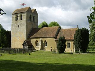
Fingest is a village in Buckinghamshire, England. It is in the Chiltern Hills near the border with Oxfordshire. It is about six miles WSW of High Wycombe. It lies in the civil parish of Hambleden.

<span class="mw-page-title-main">Taston</span> Human settlement in England

Taston is a hamlet in Spelsbury civil parish, about 1.6 miles (2.6 km) north of Charlbury and 4 miles (6.4 km) southeast of Chipping Norton, Oxfordshire.

<span class="mw-page-title-main">Brignall</span> Human settlement in England

Brignall village is located in an elevated position adjacent to the River Greta, about 2 km upstream from Greta Bridge. The village is within the Teesdale district of south-west County Durham, England, the nearest town is the market town of Barnard Castle. The village is best known for the scenic valley section of the River Greta known as Brignall Banks, which is a Site of Special Scientific Interest.

<span class="mw-page-title-main">Sockburn</span> Village in County Durham, England

Sockburn is a village and former civil parish, now in the parish of Neasham, in the Darlington district, in the ceremonial county of Durham, England. It is situated at the apex of a meander of the River Tees, to the south of Darlington, known locally as the Sockburn Peninsula. Today, all that remains of the village is an early nineteenth-century mansion, a ruined church and a farmhouse built in the late eighteenth century.

<span class="mw-page-title-main">Kershope Burn</span> River in Scotland

Kershope Burn is a small river; a tributary of both the Liddel Water and the River Esk; its final destination is the Solway Firth. The early stages begin in the Border Forest, from where it flows in a south westerly direction, followed in its entirety by the border between England and Scotland.

<span class="mw-page-title-main">River Caldew</span> River in Cumbria, England

The River Caldew is a river running through Cumbria in England. The river rises high up on the northern flanks of Skiddaw, in the Northern Fells area of the English Lake District, and flows in a northerly direction until it joins the River Eden on the north side of the city of Carlisle.

<span class="mw-page-title-main">Skirmett</span> Hamlet in England

Skirmett is a hamlet in the parish of Hambleden, in Buckinghamshire, England. It lies in the Hambleden Valley in the Chiltern Hills, between the villages of Hambleden and Fingest.

<span class="mw-page-title-main">Rosedale, North Yorkshire</span> Valley in North Yorkshire, England

Rosedale is a valley located almost in the centre of the North York Moors national park in North Yorkshire, England. The nearest town is Kirkbymoorside, some 7 miles (11 km) to the south. Rosedale is surrounded by moorland. To the north-west sits Blakey Ridge at over 1,300 feet (400 m) above sea level. At Dale Head is the source of the River Seven,which flows down the valley to join the River Rye at Little Habton near Malton. At its southern end Rosedale is squeezed between Spaunton Moor and Hartoft Rigg, where the river flows out through Forestry Commission woodland before passing the village of Cropton to reach the plains of the Vale of Pickering.

<span class="mw-page-title-main">Seacourt</span> Deserted medieval village in Oxfordshire, UK

<span class="mw-page-title-main">Wootton, West Oxfordshire</span> Human settlement in England

Wootton is a village and civil parish on the River Glyme about 2 miles (3 km) north of Woodstock, Oxfordshire. In recent years the village is sometimes referred to as Wootton-by-Woodstock to distinguish it from Wootton, Vale of White Horse. The 2011 Census recorded the parish's population as 569.

<span class="mw-page-title-main">Hob (folklore)</span> Household spirit

A hob is a type of small mythological household spirit found in the English Midlands, Northern England, and on the Anglo-Scottish border, according to traditional folklore of those regions. They could live inside the house or outdoors. They are said to work in farmyards and thus could be helpful; however, if offended they could become nuisances. The usual way to dispose of a hob was to give them a set of new clothing, the receiving of which would make the creature leave forever. It could, however, be impossible to get rid of the worst hobs.

<span class="mw-page-title-main">River Seven</span> River in North Yorkshire, England

The River Seven is a river in North Yorkshire, England. It rises on Danby High Moor, in the middle of the North York Moors, and flows south for about 15 miles (24 km) to meet the River Rye, at Brawby.

<span class="mw-page-title-main">Thynghowe</span> Ancient open-air assembly place

Thynghowe was an important Viking Era open-air assembly place or thing, located at Sherwood Forest, in Nottinghamshire, England. It was lost to history until its rediscovery in 2005 by the husband and wife team of Stuart Reddish and Lynda Mallett, local history enthusiasts.

<span class="mw-page-title-main">Whitfield, Derbyshire</span> Human settlement in England

Whitfield is a hamlet and former parish in Derbyshire, England. It is half a mile (1km) south of Glossop Town Hall, south of Glossop Brook between Bray Clough and Hurst Brook. Whitfield was one of the original townships in the ancient Parish of Glossop. Up to the latter part of the 18th century the hamlet was devoted mostly to agriculture with an area of 2,608 statute acres. The area rises from about 169m to about 266m above mean sea level.

<span class="mw-page-title-main">Hannah's Meadows</span>

Hannah's Meadows is a Site of Special Scientific Interest in the Teesdale district of south-west County Durham, England. It consists of three fields, located at Low Birk Hatt Farm, on the north side of Blackton Reservoir, in Baldersdale, some 7 km west of the village of Cotherstone. The site is named after Hannah Hauxwell, whose farm it was for over 50 years.

<span class="mw-page-title-main">Rey Cross</span>

<span class="mw-page-title-main">River Seph</span> River in North Yorkshire, England

The River Seph is a tributary of the River Rye in North Yorkshire, England. The river flows for 13 miles (20.5 km) down Bilsdale and meets the Rye near the village of Hawnby. When the surrounding land was owned by Roger de Mowbray, the river was referred to as the Sep.

<span class="mw-page-title-main">Eadwig's Charter to Abingdon Abbey c.957</span>

In a charter of c. 957 AD, King Eadwig granted twenty hides of land to Abingdon Abbey.

aet Hengestesige , and aet Seofecanwyrthe , and aet Wihtham

The place name Hampton is of Old English origin and is common in England, particularly in the South of England and Central England. It can exist as a name in its own right or as a prefix or suffix. The name suggests a farm settlement, especially one where pastoral farmers keep livestock on flood-meadow pastures.

References

Notes

  1. British History Online. . . " The river Coln, rising at springs in Sevenhampton and Charlton Abbots, to the north. . . " [3]
  2. See (Contents) > Name
  3. Distance calculated between OS grid references.
  4. British History Online. . . " The parish name, first recorded in 1086 and with later variants including Senhampton and Sennington. . . " [3]
  5. British History Online. . . " The south-western corner of Brockhampton Park stands on the site of the house begun by Paul Peart in or soon after 1639. . .In the late 18th century and the early 19th, when it was known as Sennington or Sevenhampton Park. . . " [3]
  6. See (Contents) > History > Sennington DMV > . . .Old Sennington is a deserted medieval village. . .
  7. See Rushbearing > Dialect names for rush
  8. WiKtionary : English dialect < seave > From Old Norse sef, whence also Danish siv, Icelandic sef and Swedish säv (“club-rush”).
  9. WiKtionary : Old Norse < sef >
    1. " sedge, rush ".
  10. WiKtionary : Old Norse < sef >
    1. " sedge, rush ".
  11. WiKtionary : Old English < seofon >
    1. " seven ".
  12. WiKtionary : Old English < hām >
    1. " home ".
    2. " property, estate, farm ".
    3. " village; community ".
  13. WiKtionary : Old English < tūn >
    1. " an enclosed piece of ground "
    2. " a village or town "
  14. Distance calculated between OS grid references.
  15. See also Seven Wells Hill.
  16. WiKtionary : Old Norse < sef >
    1. " sedge, rush ".
  17. WiKtionary : Old English < seofon >
    1. " seven ".
  18. Sevenhampton. . . " This name, which finds parallels in the neighbouring counties. . .and Ekwall has therefore proposed that these names embody some older p.n. such as seofon wyllas (seven wells). . . " [7]
  19. MAGiC MaP: See Table of Contents:
    • Administrative Geographies > Parish boundary.
    • Designations > Scheduled Monuments.
    • Designations > Listed Buildings.
    Use Table of Contents for Colour mapping.
  20. There might be intermittent problems with the website – if so then try again another time.
  21. See Grade II* listed buildings in Cotswold (district).
  22. British History Online . . . " Puckham woods (or wood), which were partly in Prestbury parish, were presumably represented in 1086 by woodland recorded on the bishop of Hereford's Prestbury estate. . . " [3]
  23. Woodland 3.0 miles (4.8 km) * 1.5 miles (2.4 km)
  24. British History Online. . . " The bishop had established a warren in the woods by the 1270s. . . " [3]
  25. See European rabbit > In the British Isles
  26. WiKtionary : English < cony >
    1. " A rabbit, especially the European rabbit."
  27. British History Online. . . " under an agreement of 1657. . .the warren was destroyed . . .the lady of Prestbury had liberty to dispose of the coneys [lower-alpha 26] in that part of the woods belonging to her manor. . . " [3]
  28. British History Online. . . " the episcopal estate derived an income from sales of wood and undergrowth in the later Middle Ages. . . " [3]
  29. British History Online . . . " In the later 14th century, when the bishop of Hereford wintered sheep at Puckham. . .Llanthony Priory kept a flock in Sevenhampton for at least part of the year. . .The priory reserved the hay from its meadows and tithes as fodder for its sheep . . . " [3]
  30. British History Online. . . " Puckham woods, which were partly in Prestbury. . .had been used as a common in the 1270s. . .and the tenants of Sevenhampton manor had a customary right to graze horses and cattle but not sheep throughout the year in them in 1503. . . " [3]
  31. See United Kingdom Biodiversity Action Plan > Priority habitats
  32. The Watlington Viking Hoard. . . " following Alfred's defeat of Guthrum's army at Edington in 878, Guthrum's army moved north to Cirencester in Southern Mercia where they based themselves for about a year. . . " [18]
  33. The Watlington Viking Hoard. . . " Guthrum's army moved north to Cirencester in Southern Mercia where they based themselves for about a year. . .Their prolonged presence in south-west Mercia. . .must have been devasting for Ceolwulf's position. . .there might have been battles between the Viking's and the Mercian's. . .Alfred was the eventual beneficiary of whatever happened there . . . " [18]
  34. See (Contents) > Local place names > Danish place names.
  35. See Repton, Derbyshire > History . . .Viking camp with a D-shaped earthwork.
  36. The Watlington Viking Hoard. . . " Guthrum's army moved in 879 from Cirencester to East Anglia . . . " [18]
  37. See (Contents) > Local place names > Danish place names.
  38. Vikings c.825–900 (Martin J. Ryan). . . " In the year following Edington a new Viking army . . .it would eventually return to Wessex in 892. . .For the next four years this army would play a cat-and-mouse game with Alfred. . .by the summer of 896 it was largely a spent force. . . " [19]
  39. See Battle of Edington > Consequences > . . . By 896 the Vikings had given up, with some going to East Anglia. . .
  40. British History Online. . . " East of the road 12th- and 13th-century pottery has been recovered at the site of a deserted settlement high above the Coln valley in a place, near the head of a dry side valley. . .known by the mid 16th century as Old Sennington. . . " [3]
  41. Sennington (University of Hull). . . " The earthwork remains of a settlement known as Old Sennington can still be seen from the air. These include at least two north-south hollow ways, and a number of indistinct croft boundaries. . .A report of coins having been discovered was published in 1889 which also suggested that the original chapel of Sevenhampton may have been located at the settlement (Hall 1889-90) . . .Unpublished excavations at the site in 1936 revealed stone walls as well as twelfth and thirteenth-century pottery (Baldwyn and O’Neil 1958, Dunning 1949). . . " [20]
  42. See Satterthwaite & Rusland School
  43. See River Cover > Settlements.
  44. Chapter Seven THE SCANDINAVIAN ELEMENT (P H Reaney). . . " Old Norse sætr "a mountain pasture, a shieling". . .is common in the mountainous districts of Cumberland and Westmorland. . .Examples in Cumberland: Examples in Westmorland: Examples in North Riding of Yorkshire:
  45. Aelfred's Britain (Max Adams). . . " At least two Scandinavian language traditions arrived in the British Isles during the ninth century:
  46. Aelfred's Britain (Max Adams) . . . " Words loaned both ways between Old English and Old Norse. . . [23]
  47. 0.5 miles (0.80 km) east of the Salt Way.
  48. Roel Gate – " Road to Roel ".
  49. British History Online. . . " Near the summit of Bespidge hill, known as Grim's hill in the 10th century. . .Roel Camp is a prehistoric earthwork, probably an Iron-Age hillfort. . . " [3]
  50. 0.5 miles (0.80 km) west of the Salt Way.
  51. WiKtionary : Old Norse < Grímr >
    1. " a male given name, especially one of Óðinn's name ".
  52. 0.5 miles (0.80 km) east of the Salt Way.
  53. The Hoar Stone is near Duntisbourne Abbots.
  54. 2.0 miles (3.2 km) west of the Roman road.
  55. 2.0 miles (3.2 km) west of the Roman road.
  56. The Hailes Abbey stream is a tributary of the River Isbourne.
  57. WiKtionary : Old Norse < bekkr >
    1. " brook, creek ".
  58. Aelfred's Britain (Max Adams) . . . " Words loaned both ways between Old English and Old Norse. . . " [23]
  59. WiKtionary : English < beck >
    1. " (Norfolk, Northern English dialect) A stream or small river. "
  60. WiKtionary : Old English < burg >
    1. " city or town "
    2. " fortified place: fortress, castle. "
  61. WiKtionary : Old Norse < Grímr >
    1. " a male given name, especially one of Óðinn's name ".
  62. See also Grim's Ditch > Etymology

Citations

  1. "Church of St. Andrew". National Heritage List for England. Historic England. Retrieved 10 December 2020.
  2. 1 2 3 4 5 6 7 8 9 10 11 12 Cragoe, Jurica & Williamson 2001, pp. 166–187.
  3. 1 2 3 "MAGiC MaP : Sevenhampton village – St Andrew's Church". Natural England – Magic in the Cloud.
  4. 1 2 3
  5. 1 2 3 * "SEVENHAMPTON". Open Domesday. Retrieved 2 June 2023.
  6. 1 2 3 4 5 6 7
  7. 1 2 The handwritten 'u' is interpretated as 'v'.
  8. 1 2 "MAGiC MaP : Seven Springs". Natural England – Magic in the Cloud.
  9. 1 2 "MAGiC MaP : Seven Wells". Natural England – Magic in the Cloud.
  10. 1 2 "MAGiC MaP : Sevenhampton parish boundary". Natural England – Magic in the Cloud.
  11. "MAGiC MaP : Cptswolds – Administrative boundaries". Natural England – Magic in the Cloud.
  12. "MAGiC MaP : Cptswolds AONB". Natural England – Magic in the Cloud.
  13. 1 2 "MAGiC MaP : Brockhampton Park – Wood-pasture and parkland". Natural England – Magic in the Cloud.
  14. 1 2 "MAGiC MaP : Sennington DMV". Natural England – Magic in the Cloud.
  15. 1 2 "MAGiC MaP : Puckham Woods SSSI". Natural England – Magic in the Cloud.
  16. "MAGiC MaP : Sevenhampton parish – Woodland". Natural England – Magic in the Cloud.
  17. 1 2 3 Williams & Naylor 2016, pp. 29.
  18. Higham & Ryan 2015, p. 262.
  19. Historic England. "Sennington ancient village. (1003335)". National Heritage List for England . Retrieved 1 July 2023.
  20. Reaney 1969, pp. 174–175.
  21. 1 2 3 Adams 2017, p. 136.
  22. 1 2 "MAGiC MaP : Beckbury near Hailes Abbey". Natural England – Magic in the Cloud.
  23. 1 2 Historic England. "Beckbury camp, Hailes. (1003319)". National Heritage List for England . Retrieved 2 July 2023.
  24. "MAGiC MaP : Roel Gate on the Salt Way". Natural England – Magic in the Cloud.
  25. 1 2 "MAGiC MaP : Grims Hill near Roel Gate". Natural England – Magic in the Cloud.
  26. 1 2 Historic England. "Camp S of Bespidge Wood, near Sudeley. (1004838)". National Heritage List for England . Retrieved 2 July 2023.
  27. 1 2
  28. "MAGiC MaP : Roelside DMV". Natural England – Magic in the Cloud.
  29. Historic England. "Medieval and later settlement remains at Hawling. (1405912)". National Heritage List for England . Retrieved 2 July 2023.
  30. "MAGiC MaP : Compton Abdale". Natural England – Magic in the Cloud.
  31. "MAGiC MaP : The Haw, River Severn". Natural England – Magic in the Cloud.
  32. "MAGiC MaP : Hoar Stone (Long barrow)". Natural England – Magic in the Cloud.
  33. Historic England. "Hoar Stone long barrow. (1018161)". National Heritage List for England . Retrieved 2 July 2023.
  34. "MAGiC MaP : Hoarston (hamlet) near Ebrington". Natural England – Magic in the Cloud.
  35. "MAGiC MaP : Daneway (hamlet) near Sapperton". Natural England – Magic in the Cloud.

Sources

Commons-logo.svg Media related to Sevenhampton, Gloucestershire at Wikimedia Commons