
Arietta is a town in Hamilton County, New York, United States. The population was 304 at the 2010 census. The town was named after the mother of one of the first settlers, Rensselaer Van Rennslaer.

Tyrone Township is a township in Blair County, Pennsylvania, United States. It is part of the Altoona, PA Metropolitan Statistical Area. The population was 1,885 at the 2010 census.

A sickle, bagging hook or reaping-hook, is a hand-held agricultural tool designed with variously curved blades and typically used for harvesting, or reaping, grain crops or cutting succulent forage chiefly for feeding livestock, either freshly cut or dried as hay. Falx was a synonym but was later used to mean any of a number of tools that had a curved blade that was sharp on the inside edge such as a scythe.

Skyvatn is a lake in the northern part of the municipality of Bykle in Aust-Agder county, Norway. The lake is located south of the lake Holmavatnet and northwest of the lake Hartevatnet. The village of Hovden in Bykle is the nearest village, located about 9 kilometres (5.6 mi) southeast of the lake.
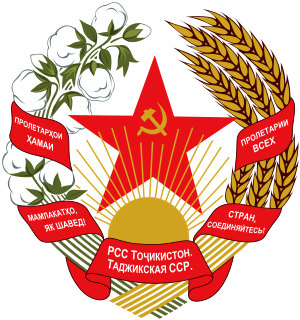
The State Emblem of the Tajik Soviet Socialist Republic was adopted on March 1, 1937 by the government of the Tajik Soviet Socialist Republic. The emblem is based on the State Emblem of the Soviet Union. It shows symbols of agriculture. The red star is prominently featured with a small hammer and sickle within it. The rising sun stands for the future of the Tajik nation, and the star as well as the hammer and sickle for the victory of communism and the "world-wide socialist community of states". The emblem was replaced with the new emblem in 1992, which uses a similar design to the Soviet one.
Brush Mountain is a stratigraphic ridge in the Appalachian Mountains of central Pennsylvania, USA, running east of the Allegheny Front and west of Tussey Mountain. It lies along the southeast side of Little Juniata River and both sides of the Sinking Run, and is the westernmost ridge in its section of the Ridge-and-valley Appalachians. The western ridge line separates the Logan Valley from the Sinking Valley.

Fir Mountain is a mountain located in Ulster County, New York. The mountain is part of the Catskill Mountains. Fir Mountain is flanked to the northwest by Big Indian Mountain, and to the southeast by Spruce Mountain.

Allium siskiyouense is a North American species of wild onion known by the common name Siskiyou onion. It is native to the Klamath Mountains and nearby ranges of northern California and Oregon. It grows in serpentine and other rocky soil types.

Sickle cell disease (SCD) is a group of blood disorders typically inherited from a person's parents. The most common type is known as sickle cell anaemia (SCA). It results in an abnormality in the oxygen-carrying protein haemoglobin found in red blood cells. This leads to a rigid, sickle-like shape under certain circumstances. Problems in sickle cell disease typically begin around 5 to 6 months of age. A number of health problems may develop, such as attacks of pain, anemia, swelling in the hands and feet, bacterial infections and stroke. Long-term pain may develop as people get older. The average life expectancy in the developed world is 40 to 60 years.

The Little Harquahala Mountains are a small, arid, low-elevation mountain range of western-central Arizona, in the southeast of La Paz County.

The Granite Wash Mountains are a short, arid, low elevation mountain range of western-central Arizona, in the southeast of La Paz County. The range borders a slightly larger range southeast, the Little Harquahala Mountains; both ranges form a section on the same water divide between two desert washes. The washes flow in opposite directions, one northwest to the Colorado River, the other southeast to the Gila River.

Clarke Glacier is a 2-mile-wide, 20-mile-long glacier, located on the west coast of Graham Land in Antarctica. It flows west, along the north side of Sickle Mountain and the Baudin Peaksm, to Mikkelsen Bay.
Ichhunayuq is a mountain in the Andes of Peru, about 4,200 metres (13,780 ft) high. It is located in the Cusco Region, Calca Province, on the border of the districts of Coya and Pisac. Ichhunayuq lies at the archaeological site of Písac, northwest of the town.

Hatun Ichhuna Kunka is a mountain in the La Raya mountain range in the Andes of Peru, about 5,000 metres (16,404 ft) high. It is located in the Cusco Region, Canas Province, Layo District, and in the Puno Region, Melgar Province, Santa Rosa District. Hatun Ichhuna Kunka lies near the La Raya pass southwest of Kunka. Huch'uy Ichhuna Kunka and Pichaqani are the lower elevations of the ridge to the northwest.

Huntersfield Mountain is a mountain located in the Catskill Mountains of New York north-northwest of Ashland. Ashland Pinnacle is located east, and Tower Mountain is located south-southeast of Huntersfield Mountain. It is the highest point in Schoharie County and it is ranked 9 of 62 on the list of New York County High Points.
Mount Pisgah is a mountain located in the Catskill Mountains of New York north of Windham. Steenburg Mountain is located northwest, Richtmyer Peak is located west, and Mount Nebo is located southeast of Mount Pisgah.
Steenburg Mountain is a mountain located in the Catskill Mountains of New York north-northwest of Windham. High Knob is located northwest, Sicklers Mountain is located west-southwest, South Mountain is located south, and Mount Pisgah is located southeast of Steenburg Mountain.
Stevens Mountain is a mountain located in the Catskill Mountains of New York southeast of Gilboa. Reed Hill is located north-northwest, Bull Hill is located northeast, and Mount Royal is located south of Sicklers Mountain.

The Knob is a mountain in Greene County, New York. It is located in the Catskill Mountains north-northeast of Ashland. Ashland Pinnacle is located north, and Huntersfield Mountain is located northwest of The Knob.

The Pennsylvania State Game Lands Number 166 are Pennsylvania State Game Lands in Blair and Huntingdon Counties in Pennsylvania in the United States providing hunting, trapping, bird watching, and other activities.


