
Benson County is a county in the U.S. state of North Dakota. As of the 2010 United States Census, the population was 6,660. Its county seat is Minnewaukan. The county was created on March 9, 1883 by the Dakota Territory legislature, and was named for Bertil W. Benson, a Dakota Territory legislator at the time. The county government was organized on June 4, 1884, and its boundary lines were altered by two legislative actions in 1885.

Arietta is a town in Hamilton County, New York, United States. The population was 304 at the 2010 census. The town was named after the mother of one of the first settlers, Rensselaer Van Rennslaer.

Benson is a town in Hamilton County, New York, United States. The population was 192 at the 2010 census. The town is on the south border of Hamilton County and is northwest of Schenectady. The current Town Supervisor is John M. Stortecky.

Multnomah Falls is a waterfall located on Multnomah Creek in the Columbia River Gorge, east of Troutdale, between Corbett and Dodson, Oregon, United States. The waterfall is accessible from the Historic Columbia River Highway and Interstate 84. Spanning two tiers on basalt cliffs, it is the tallest waterfall in the state of Oregon at 620 ft (189 m) in height.

The Inland Northwest—historically and alternatively known as the Inland Empire—is a region of the Northwest centered on the Greater Spokane Area, that includes all of Eastern Washington and North Idaho. Northeastern Oregon and Western Montana are also sometimes considered part of the Inland Northwest, although Western Montana generally is not considered part of the Inland Empire. Under some definitions, the Inland Empire also excludes Central Washington or Idaho County, Idaho.

Belgrave is a suburb in Melbourne, Victoria, Australia, 36 km east of Melbourne's central business district. Its local government area is the Shire of Yarra Ranges. At the 2016 Census, Belgrave had a population of 3,929.
The Lakes Region of New Hampshire is located in the east-central part of the state, south of the White Mountains Region and extending to the Maine border. It is named for the numerous lakes in the region, the largest of which are Lake Winnipesaukee, Winnisquam Lake, Squam Lake, and Newfound Lake. The area comprises all of Belknap County, the southern portion of Carroll County, the eastern portion of Grafton County, and the northern portions of Strafford County and Merrimack County. The largest municipality is the city of Laconia.

Kittatinny Mountain is a long ridge traversing across northwestern New Jersey running in a northeast-southwest axis, a continuation across the Delaware Water Gap of Pennsylvania's Blue Mountain Ridge. It is the first major ridge in the far northeastern extension of the Ridge and Valley province of the Appalachian Mountains, and reaches its highest elevation, 1,803 feet, at High Point in Montague Township. Kittatinny Mountain forms the eastern side of Wallpack Valley; the western side comprises the Wallpack Ridge (highest elevation: 928 feet above sea level.

The Lillooet Ranges are the southeasternmost subdivision of the Pacific Ranges of the Coast Mountains of British Columbia. They are located between the drainage of the Lillooet River and Harrison Lake on the west and the canyon of the Fraser River on the east, and by the lowland coastal valley of that river on the south.

Saddleback Mountain is a mountain located in Piscataquis County, Maine.

The Silver Lake Wilderness Area, an Adirondack Park unit of the Forest Preserve, is located in the towns of Lake Pleasant, Benson, Wells and Arietta in Hamilton County and is roughly bounded on the north by NY 8 and private lands near Piseco Lake, Oxbow Lake, Hamilton Lake, Sand Lake and Lake Pleasant; on the east by NY 30; on the south generally by the Hamilton County line; and on the west by NY 10, the West Branch of the Sacandaga River and the Piseco Outlet.
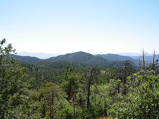
The Bradshaw Mountains are a mountain range in central Arizona, United States, named for brothers Isaac and William D. Bradshaw after their deaths, having been formerly known in English as the Silver Mountain Range.
Saskatchewan Highway 705 connects Saskatchewan Highway 358 at Wood Mountain in the rural municipality of in Old Post to SK Hwy 47 in Benson. Highway 705 travels through Halbrite. The length of Highway 705 is 286.6 kilometres (178.1 mi).

Maturango Museum is located in Ridgecrest, California. The museum is best known for the guided tours of the Coso Rock Art District located on China Lake Naval Weapons Station. The museum offers exhibits and displays featuring both the natural and the cultural history and diversity of the Northern Mojave Desert with exhibits of animals, plants, rocks and minerals, Native American artifacts, and contemporary arts and crafts.
The New York and Greenwood Lake Railway owned a line between Croxton, Jersey City, New Jersey and Greenwood Lake, New York. Service on the line was provided by the Erie Railroad.
Silver Lake National Wildlife Refuge is a National Wildlife Refuge in Benson and Ramsey counties in North Dakota. It is managed under Devils Lake Wetland Management District.

Silver Lake is an unincorporated community in Preston County, West Virginia, United States. Silver Lake is located along U.S. Route 219 7.5 miles (12.1 km) north of Thomas in Tucker County.

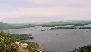
Silver Lake Mountain is a 2,372 ft mountain in the North-Eastern Adirondacks located near Ausable Forks, NY.

White Lake Mountain is a summit located in the Adirondack Mountains of New York located in the Town of Benson west-northwest of the hamlet of Upper Benson.
Rock Lake Mountain is a summit located in the Adirondack Mountains of New York located in the Town of Benson west-northwest of the hamlet of Upper Benson.

