
Snake Alley is a street located in Burlington, Iowa, which was built in 1894. In 2017, Ripley's Believe It or Not! recognized the street as "Unbelievably Crooked" and the #1 Odd Spot in their Odd Spots Across America Campaign.

The Woodlawn Historic District is a nationally recognized historic district located in Iowa City, Iowa, United States. It was listed on the National Register of Historic Places in 1979. At the time of its nomination it consisted of 14 resources, all of which are contributing buildings. The district is largely on Woodlawn Street, a gravel dead-end extension of Iowa Avenue. The eastern terminus of Iowa Avenue was originally planned to be a block to the west and was to be the location of the Governor's Mansion, but its was never built. The Old Capitol is on western terminus of the same street. The district is an enclave of upper middle-class houses on Woodlawn and Evans Streets. Nine of the houses were built in the late 19th century, two were built in the 1920s, and two were built in mid-20th century. There is also a four-story Tudor Revival apartment building on Evans Street that was built in 1926. All of the buildings are located on deep set-backs on large landscaped lots that provide seclusion and cohesion, which is what gives them their significance. The most prominent house is a Queen Anne style home at 1036 Woodlawn Street.

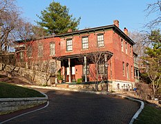
The Riverview Terrace Historic District is a 15.2-acre (6.2 ha) historic district in Davenport, Iowa, United States, that was listed on the National Register of Historic Places in 1984. It was listed on the Davenport Register of Historic Properties in 1993. The neighborhood was originally named Burrow's Bluff and Lookout Park and contains a three-acre park on a large hill.

The Outing Club is located in the central part of Davenport, Iowa, United States. It has been listed on the National Register of Historic Places since 1977. In 1985 it was included as a contributing property in the Vander Veer Park Historic District.

The House at 919 Oneida Street is a historic building located on the east side of Davenport, Iowa, United States. It has been listed on the National Register of Historic Places since 1984.

The Mahaska County Courthouse located in Oskaloosa, Iowa, United States, was built in 1886. It was individually listed on the National Register of Historic Places in 1981 as a part of the County Courthouses in Iowa Thematic Resource. In 1986 it was included as a contributing property in the Oskaloosa City Square Commercial Historic District. The courthouse is the second building the county has used for court functions and county administration.

The Chautauqua Park Historic District is located on the north side of Des Moines, Iowa, United States. It has been listed on the National Register of Historic Places since 1990. It is part of the Suburban Development in Des Moines Between the World Wars, 1918--1941 MPS.

The Heritage Hill Historic District is primarily a residential area north of downtown Burlington, Iowa, United States. It was listed on the National Register of Historic Places in 1982. The historic district is primarily a residential neighborhood on the hill north of the central business district. Several churches act as a buffer and provide a transition from the residential area and the commercial areas in the valley. At the time of its nomination there were 141 structures in the district. The breakdown of their uses at that time included: 113 residences, 10 churches or religious use facilities, 7 public or government buildings, and 11 commercial structures. The district also includes North Hill Park, which has been in continuous use since the city was founded in 1836 and is one of the two oldest city parks in Burlington.

Lacey-Keosauqua State Park is located southwest of Keosauqua, Iowa, United States. Located along the Des Moines River in Van Buren County, it was dedicated in 1921. It is the largest state park in size in Iowa. In 1990 three areas were named nationally recognized historic districts and listed on the National Register of Historic Places.

The Oak Hill Historic District, also known as East Fort Dodge, is a nationally recognized historic district located in Fort Dodge, Iowa, United States. It was listed on the National Register of Historic Places in 1977. At the time of its nomination the district consisted of 22 resources, including 17 contributing buildings, and five noncontributing buildings. The contributing buildings are all houses, including the Vincent House (1871), except for two buildings. The exceptions are the Bennett Carriage House (1890) and the Blanden Art Gallery (1930). The houses were built in various styles from 1866 to 1916. Three apartment buildings, a funeral hone, and Grace Lutheran Church (1955) are the non-contributing buildings.

The Seminary Hill Residential Historic District is a nationally recognized historic district located in Dubuque, Iowa, United States. It was listed on the National Register of Historic Places in 2015. At the time of its nomination it consisted of 55 resources, which included 38 contributing buildings, one contributing site, one contributing object, 13 non-contributing buildings, one non-contributing structure, and one non-contributing object. The district is a blufftop residential area that surrounds Madison Park. It takes its name from its proximity to the former German Theological Seminary, now the seminary located at the University of Dubuque. Clarke Drive, the main artery through the district, was also known as Seminary Street at one time. About half of the historic buildings here are brick. The Italianate style is dominate, with several examples of the Italian Villa design. There are also a few examples of the Second Empire, Queen Anne, and Classical Revival styles. This residential area was developed between 1855 and 1919.

Old Town Historic District is a nationally recognized historic district located in Ames, Iowa, United States. It was listed on the National Register of Historic Places in 2004. At the time of its nomination it consisted of 249 resources, which included 191 contributing buildings, one contributing site, and 57 non-contributing buildings. The district is a residential area located north of the central business district. Between the two is a "civic corridor" made up of government buildings, churches and fraternal organizations. The earlier residences here were built of brick, but from about 1890 to 1910 they are all of wood construction. Brick reappears in 1910, but as a secondary building material. The houses are from one to two stories in height. They reflect the Late Victorian styles as well as the Colonial Revival styles of the early 20th century. The houses generally have a detached garage behind the house, facing an alley. The Prof. J.L. Budd, Sarah M., and Etta Budd House (1885) is individually listed on the National Register.

The Bohumil Shimek House is a historic building located in Iowa City, Iowa, United States. The two-story, frame, Folk Victorian structure was built sometime around 1890. Its significance is its association with Bohumil Shimek. Initially trained as a civil engineer, he is better known as a naturalist, conservationist, and botany professor at the University of Iowa. He lived here from 1899 until his death in 1937. These dates coincide with his professional career. Shimek contributions include establishing the state park system in Iowa, the Iowa Lakeside Laboratory, the American School of Wild Life Protection, and the Upper Mississippi River National Wildlife and Fish Refuge. He published over 190 scholarly works, and is credited with the discovery of the origins of the Loess Hills.

The Billingsley-Hills House, also known as the Veatch Residence, is a historic building located in Iowa City, Iowa, United States. This is one of several transitional Greek Revival to Italianate houses built in this area in the years before and after the American Civil War making it a very popular style here. Over the years, however, most of them have either been torn down or altered beyond recognition leaving this house as one of few left with its integrity intact. When this house was built in 1870 it was situated on a 38-acre (15 ha) estate, but by the turn of the 20th-century the lot was reduced to its present size. Situated in a residential area with the University of Iowa Hospitals and Clinics across the street, the two-story frame house features a low pitched gable roof, bracketed eaves, an entablature with dentils and returns, and a wrap-around front porch.

The College Green Historic District is a nationally recognized historic district located in Iowa City, Iowa, United States. It was listed on the National Register of Historic Places in 1997. At the time of its nomination it consisted of 47 resources, which included 37 contributing buildings, one contributing site, and nine non-contributing buildings. This neighborhood in the central part of the city surrounds a square-block park called College Green, from which it derives its name. The park, which is the contributing site, is found on the earliest maps of Iowa City. While the earliest houses in the district were built in the 1860s, most were constructed between 1890 and 1920. No one architectural style dominates here, but the district contains a variety of styles that were popular in the late 19th and early 20th centuries. This is one of three areas in the city where the fraternities and sororities associated with the University of Iowa are located. The Thomas C. Carson House (1875), which now houses a sorority, is individually listed on the National Register of Historic Places.

The Pucker Street Historic District is a nationally recognized historic district located in Marion, Iowa, United States. It was listed on the National Register of Historic Places in 2002. At the time of its nomination it consisted of 84 resources, which included 50 contributing buildings, three contributing structures, two contributing objects, and 29 non-contributing buildings. The historic district is a residential area near Marion's central business district. The people who initially built homes here were the city's pioneer families and then their descendants. It is also where the city's wealthy and influential citizens built their houses along Eighth Avenue and its adjacent streets. The neighborhood was called "Pucker Street" because of the superior attitudes that some of its early residents were said to have possessed.

The Larnerd Case House, also known as Rose Hill, is a historic building located in Des Moines, Iowa, United States. This two-story, frame, Greek Revival structure is the oldest dwelling that is still standing in the city. The second floor dormer and the front porch are not original to the house. This section of Iowa was opened for settlement in 1845 after a treaty with the Sauk and Meskwaki (Fox) tribes. Larnerd Case, an Ohio native, built this house using black walnut cut from the property in 1846. He lived on what was then a 160-acre (65 ha) farm until his death in 1857. The residential area that surrounds the house and the park across the street were once part of the farm. The house was listed on the National Register of Historic Places in 1982.

The Polk County Homestead and Trust Company Addition Historic District is a nationally recognized historic district located in Des Moines, Iowa, United States. It was listed on the National Register of Historic Places in 2016. At the time of its nomination the district consisted of 86 resources, including 48 contributing buildings, 11 contributing structures, 18 non-contributing buildings, and nine non-contributing structures. The end of the 19th-century saw the rise of the Victorian suburbs around Des Moines. This was a period of economic growth for the metropolitan area. The largest of these suburbs was North Des Moines. It was connected to Des Moines by way of three streetcar lines, whiched added to its attractiveness. Local real estate investors established the Polk County Homestead & Trust Co. to develop the northern portion of North Des Moines in partnership with the Prospect Park Improvement Company.

Chariton Cemetery is located in Chariton, Iowa, United States. It was listed as a historic district on the National Register of Historic Places in 2010. At the time of its nomination the district consisted of five resources, including one contributing building, two contributing sites, one contributing structure, and one non-contributing building. The Chariton Cemetery Company was incorporated in 1864 as a private cemetery. It was sold to the city for $10,000 in 1924. That same year they hired Des Moines landscape architect Ray F. Wyrick to plan the landscaping and for future expansion. The plan he came up with was the rural cemetery concept. He replaced its formal garden design with curving roadways and waterways that reflected its natural setting. Babyland for infant burials was created in 1930. He also designed the north entrance gate, which was built with Works Progress Administration funds in 1937. Wyrick continued to work with the cemetery into the 1960s.

The Davenport Motor Row and Industrial Historic District is a nationally recognized historic district located on the eastern edge of downtown Davenport, Iowa, United States. It was listed on the National Register of Historic Places in 2019. At the time of its nomination it consisted of 28 resources, which included 20 contributing buildings, one contributing site, one contributing structure, and six non-contributing buildings. The area was previously a part of the nortorious Bucktown, a district of saloons, beer gardens, brothels, billiard parlors, gambling establishments, and theaters. Davenport licensed prostitution in the 1893, gambling in 1904, and failed to enforce Iowa prohibition laws during this period. A crusade against vice by Davenport's Catholic bishop, Henry Cosgrove, and reforms by state leaders led to the district's transformation in the early 20th century into a light industrial area. The city's automobile industry settled here beginnig in the 1910s. They stayed until the mid-20th century when Interstate 80 was completed on the north side of the city and they moved to the suburban areas. U.S. Route 32 and its successor U.S. Route 6 passed through the district on East Second Street from 1926 to 1937. The Government Bridge (1896), which for years was the city's only bridge across the Mississippi River, is immediately adjacent to the district.


 Peter Bouquet House (1871)
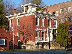 William Fordney House (1845)
 Garrett-Phelps House (1851)


