
Vantage is a census-designated place (CDP) in Kittitas County, Washington, United States. The population was 74 at the 2010 census.

The Eagle Point Bridge was a very narrow two-lane automobile bridge that connected urban Dubuque, Iowa, and rural Grant County, Wisconsin. It was part of the US 61/US 151 route, and was a toll bridge. After the new Dubuque-Wisconsin Bridge was built in 1983, the Eagle Point Bridge was torn down. At the end, the toll was ten cents, both ways, collected on the Iowa side.

The Interstate Bridge is a pair of nearly identical steel vertical-lift, Parker through-truss bridges that carry Interstate 5 traffic over the Columbia River between Vancouver, Washington and Portland, Oregon in the United States.

The Lewis and Clark Bridge is a cantilever bridge that spans the Columbia River between Longview, Washington, and Rainier, Oregon. At the time of its completion, it had the longest cantilever span in the United States.

The Astoria–Megler Bridge is a steel cantilever through truss bridge in the northwest United States that spans the lower Columbia River, between Astoria, Oregon, and Point Ellice near Megler, Washington. Opened 56 years ago, in 1966, it is the longest continuous truss bridge in North America.

The Dingmans Bridge is a toll bridge across the Delaware River between Delaware Township, Pennsylvania and Sandyston Township, New Jersey. Owned and operated by the Dingmans Choice and Delaware Bridge Company, it is the last privately-owned toll bridge on the Delaware and one of the few remaining in the United States. It is also the only bridge on the Delaware to toll traffic entering New Jersey.

The National Register of Historic Places in the United States is a register including buildings, sites, structures, districts, and objects. The Register automatically includes all National Historic Landmarks as well as all historic areas administered by the U.S. National Park Service. Since its introduction in 1966, more than 90,000 separate listings have been added to the register.

The Columbia–Wrightsville Bridge, officially the Veterans Memorial Bridge, spans the Susquehanna River between Columbia and Wrightsville, Pennsylvania, and carries Pennsylvania Route 462 and BicyclePA Route S. Built originally as the Lancaster-York Intercounty Bridge, construction began in 1929, and the bridge opened September 30, 1930. On November 11, 1980, it was officially dedicated as Veterans Memorial Bridge, though it is still referenced locally as the Columbia–Wrightsville Bridge.

The Fort Madison Toll Bridge is a tolled, double-decked swinging truss bridge over the Mississippi River that connects Fort Madison, Iowa, and unincorporated Niota, Illinois. A double-track railway occupies the lower deck of the bridge, while two lanes of road traffic are carried on the upper deck. The bridge is about 1 mile (1.6 km) long with a swing span of 525 feet (160 m), and was the longest and largest double-deck swing-span bridge in the world when constructed in 1927. It replaced an inadequate combination roadway/single-track bridge completed in 1887. The main river crossing consists of four 270-foot (82 m) Baltimore through truss spans and a swing span made of two equal arms, 266 feet (81 m) long. In 1999, it was listed in the National Register of Historic Places under the title, Fort Madison Bridge, ID number 99001035. It was also documented as survey number IA-62 by the Historic American Engineering Record, archived at the Library of Congress. Construction and photographic details were recorded at the time in Scientific American magazine.

The Cotter Bridge, also known as the R. M. Ruthven Bridge and the White River Concrete Arch Bridge, carries U.S. Route 62 Business across the White River west of the city of Cotter in Baxter County, Arkansas. Upon completion, the bridge opened a part of the Ozarks previously inaccessible to motorists. Constructed in 1930, it is the only bridge built by the Marsh Engineering Company of Des Moines, Iowa, in the state of Arkansas.
The Plattsmouth Bridge is a truss bridge over the Missouri River connecting Cass County, Nebraska, and Mills County, Iowa at Plattsmouth, Nebraska. Until 2014, it carried U.S. Highway 34 across the river.

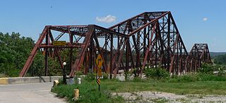
The Vantage Bridge is a bridge in the U.S. state of Washington. It carries Interstate 90 across the Columbia River, near Vantage and George, Washington. This section of the river is named Wanapum Lake; it is the reservoir formed by Wanapum Dam. The bridge separates the Ginkgo Petrified Forest and Wanapum Recreational Area State Park on the western bank of the Columbia.

State Route 261 (SR 261) is a 62.71-mile-long (100.92 km) state highway in the U.S. state of Washington. Serving Columbia, Franklin, and Adams counties, the highway begins at U.S. Route 12 (US 12) east of Starbuck and becomes concurrent with SR 260 from Kahlotus to SR 26 in Washtucna before ending at Interstate 90 (I-90) and US 395 in Ritzville. The highway has been legislated since 1937 from Ritzville to Washtucna as Secondary State Highway 11E (SSH 11E) and in 1957 from Washtucna to the Starbuck area as a branch of SSH 11B. The two secondary highways became SR 261 during the 1964 highway renumbering, and a gap between Washtucna and Starbuck was not paved until the construction of the Snake River Bridge was completed in 1968.

Lyons Ferry State Park is a public recreation area located near the confluence of the Snake and Palouse rivers, seven miles (11 km) northwest of Starbuck, Washington. The state park is on Route 261 abreast of Lake Herbert G. West, a reservoir on the Snake River created with the construction in the 1960s of the Lower Monumental Dam some 17 miles (27 km) downstream. The park offers facilities for boating, fishing, and swimming. The area is managed cooperatively by the Washington State Parks and Recreation Commission and the U.S. Army Corps of Engineers, which operates the Lyons Ferry Marina.

The Pasco–Kennewick Bridge or Benton–Franklin Inter-County Bridge, known locally as the Green Bridge, was a steel cantilever truss bridge in the northwest United States. It crossed the Columbia River in central Washington, connecting Pasco and Kennewick, two of the Tri-Cities. Succeeded by the Cable Bridge in 1978, it was demolished in 1990.

The Kettle Falls Bridges is the collective name for a pair of steel cantilever bridges carrying State Route 20/U.S. Route 395 and the Kettle Falls International Railway across the Columbia River at Kettle Falls, Washington. The south bridge carries motor vehicle traffic while the similar northern span is used for rail.

The Brownsville Bridge, also known as the Intercounty Bridge and the West Brownsville Bridge, is a truss bridge that carries vehicular traffic across the Monongahela River between Brownsville, Pennsylvania and West Brownsville, Pennsylvania. Since the opening of the Lane Bane Bridge and highway project to carry much of the intercounty through traffic away from the main streets of downtown Brownsville in the early 1960s, another commonly heard name is Old Brownsville Bridge for the four high level viaduct.
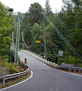
The Yale Bridge or Lewis River Bridge spans the Lewis River near Yale, Washington. It was built in 1932 by Cowlitz and Clark counties. The suspension bridge has a clear span of 300 feet (91 m), with a total length of 532 feet (162 m), replacing a previous steel truss bridge at the site. Construction of the Ariel Dam had created Lake Merwin with a water depth of 90 feet (27 m) at the site, requiring a new bridge that did not need to have support piers in the water. The road deck, stiffened by a steel Warren truss, is 50 feet (15 m) above the high water line of the reservoir.

The Red River Bridge was a truss bridge crossing the Red River at Garland, Arkansas. It carried vehicular traffic from 1931 to 1990 and has since been demolished.

