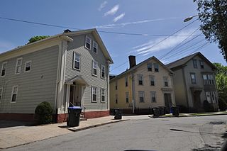
The Bridgham–Arch–Wilson Streets Historic District is a predominantly residential historic district in Providence, Rhode Island. It is located southwest of downtown Providence, and was developed beginning in the 1840s as a suburban part of the city. It is roughly in the shape of a boot, roughly bounded by Cranston, Bridgham, Elmwood, and Harrison Streets. Most of the housing is architecturally reflective of the mid-19th century, with the Greek Revival, Italianate, and Second Empire styles well represented. Development in the area slowed in the late 19th and early 20th centuries, so there are only a modest number of Queen Anne, Stick style, and Colonial Revival properties. Most of the houses are either 1-1/2 or 2+1⁄2-story wood-frame structures, and are generally set on fairly small lots. There are 175 primary buildings in the district, of which more than 150 are historically significant.
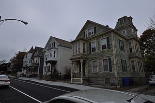
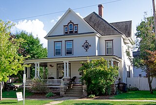
The Stimson Avenue Historic District is a residential historic district on the east side of Providence, Rhode Island. It includes all of Stimson Avenue and Diman Place, as well as adjacent properties on Angell Street on the south and Hope Street on the west, forming a relatively compact rectangular area. This area was developed roughly between 1880 and 1900, and features a collection of high-quality Queen Anne and Colonial Revival houses, with a few earlier Italianate houses at its edges. Among the finest is 19 Stimson Avenue, built in 1890 to a design by Stone, Carpenter & Willson; it is stylistically transitional between Queen Anne and Colonial Revival, featuring elaborate woodwork and a large number of exterior surface finishes, in a predominantly symmetrical Colonial Revival form. The only non-residential structure is the 1893 brick Central Congregational Church at 296 Angell Street.

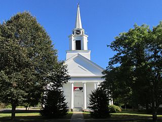
The Main Street Historic District of Westerly, Rhode Island, encompasses a predominantly residential section of Main Street and adjoining Maple Avenue and School Street. The district includes nineteen houses, which are predominantly Greek Revival, Italianate, and Second Empire in style, as well as the Pawcatuck Seventh Day Baptist Church, a Greek Revival structure built 1847–48.

The Pawtucket Congregational Church is an historic church building at 40 and 56 Walcott Street, at the junction of Broadway and Walcott St., in the Quality Hill neighborhood of Pawtucket, Rhode Island.

The South Street Historic District encompasses a small enclave of 19th-century houses on South Street between Meadow and Fruit Streets in Pawtucket, Rhode Island. Covering two blocks of South Street, it includes 21 buildings, of which 15 were built before 1850, and the rest before 1900. Most of the houses are 1+1⁄2-story wood-frame structures, with many of the larger ones showing signs of having once been of a similar size. The most common architectural style is the Greek Revival, with notable examples at 19-21 and 37-39 South Street.

St. Mary's Church of the Immaculate Conception Complex is an historic Roman Catholic church complex at 103 Pine Street in Pawtucket, Rhode Island.

Mount Pleasant Historic District is a historic district encompassing a cluster of well-preserved 19th-century residential buildings on Forest Street and Mount Pleasant Avenue in the Roxbury neighborhood of Boston, Massachusetts. First developed in 1833, it was one Roxbury's first speculative residential subdivision developments. The district features Greek Revival, Italianate, and Romanesque architecture, and was added to the National Register of Historic Places in 1989.
The North Bedford Historic District is a historic district roughly bounded by Summer, Parker, Pleasant and Kempton Streets in New Bedford, Massachusetts. It encompasses a predominantly residential neighborhood north of downtown New Bedford which was developed primarily in the mid 19th-century. It features a variety of worker housing of the period, as well as a number of higher quality houses built by businessmen. The district was added to the National Register of Historic Places in 1979.

The Attleborough Falls Historic District is a predominantly residential historic district on Mt. Hope and Towne Streets in North Attleborough, Massachusetts. Located just south of the Ten Mile River, it encompasses a stylish mid-to-late 19th century residential area that developed in a previously rural area due to industrial development across the river. The district was added to the National Register of Historic Places in 2004.
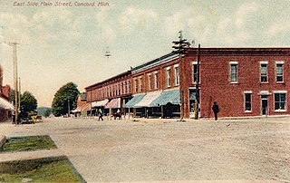
The Concord Village Historic District in Concord, Michigan dates back to 1836, and consists of historic structures located along Hanover Street from Spring to Michigan Streets and North Main Street from Railroad to Monroe Streets. It was listed on the National Register of Historic Places in 1996.
The Metamora Crossroads Historic District is a historic district centered at the intersection of Oak and High Street in the small village of Metamora in Metamora Township in Lapeer County, Michigan. It was designated as a Michigan State Historic Site and also added to the National Register of Historic Places on July 19, 1984.
The Main Street Historic District of Fryeburg, Maine, encompasses the growth of the town's principal village between about 1800 and 1935. It extends along Main Street, from Woodland Street in the north to Portland Street (SR 5 and Maine State Route 113) in the south, and includes forty primary buildings on 55 acres (22 ha). The district was listed on the National Register of Historic Places in 1991.

The Calais Historic District encompasses a city block of 19th-century commercial buildings in the center of Calais, Maine. The district, developed after a fire devastated the area in 1870, contains a cohesive concentration of brick Italianate architecture. The district was listed on the National Register of Historic Places in 1978.

The Holden–Leonard Workers Housing Historic District encompasses a collection of mill-related tenement houses, plus a former mill store, in Bennington, Vermont. They are located on Benmont and Holden Avenues, near the former Holden–Leonard Mill Complex, Bennington's largest employer in the late 19th century. The district was listed on the National Register of Historic Places in 2011.
Pritchard's Outlook Historic District is a primarily residential historic district, roughly bounded by Park Drive, Walnut Street, Crescent Street, and Davis Street, in Allegan, Michigan. It was added to the National Register of Historic Places in 1987.

The Center Avenue Neighborhood Residential District is a residential historic district located in Bay City, Michigan, running primarily along Center, Fifth, and Sixth Avenues between Monroe and Green Avenues, with additional portions of the district along Fourth between Madison and Johnson, down to Tenth Avenue between Madison and Lincoln, along Green to Ridge, and around Carroll Park. The original section, along Center and portions of Fifth and Sixth, was listed on the National Register of Historic Places in 1982. A boundary increase including the other sections of the neighborhood was listed in 2012.

The North Milford Village Historic District is a historic district located in Milford, Michigan, including the commercial area along Main Street from the Huron River to Summit, industrial areas around the mill ponds west of Main, and residential areas east of Main. The district was listed on the National Register of Historic Places in 2000.

The Dibbleville-Fentonville Historic District is a primarily residential historic district roughly bounded by Shiawassee, Riggs, Holly and George Streets in Fenton, Michigan. It was listed on the National Register of Historic Places in 1982.
The West Side Historic Residential District is a residential historic district roughly bounded by Mason, Madison, Harrison and Lyon Streets in Saginaw, Michigan. It was listed on the National Register of Historic Places in 1982.
The Moore Fabric Company Plant is a historic industrial complex at 45-47 Washington Street in Pawtucket, Rhode Island. The complex consists of five buildings built between 1878 and 1954, primarily for the purpose of manufacturing textiles with elastic components, although the oldest structure was built as a school. The complex was listed on the National Register of Historic Places in 2019. Plans have been laid to convert the property to residential use.


