St Margaret's Hope

Last updated

St Margaret's Hope
St Margaret's Hope - geograph.org.uk - 1303670.jpg
Buildings on the shore at St Margaret's Hope
Orkney Islands UK location map.svg
Red pog.svg
St Margaret's Hope
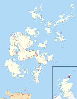
Location within Orkney
Area0.42 km2 (0.16 sq mi)
Population550 (approx.)
  Density 1,310/km2 (3,400/sq mi)
OS grid reference ND445935
Council area
Lieutenancy area
Country Scotland
Sovereign state United Kingdom
Post town ORKNEY
Postcode district KW17
Dialling code 01856
Police Scotland
Fire Scottish
Ambulance Scottish
UK Parliament
Scottish Parliament
List of places
UK
Scotland
58°49′34″N2°57′40″W / 58.826°N 2.961°W / 58.826; -2.961

St Margaret's Hope is a village in the Orkney Islands, off the north coast of Scotland. It is known locally as The Hope or The Hup. With a population of about 550, it is Orkney's third largest settlement after Kirkwall and Stromness.[ citation needed ]

St Margaret's Hope is the main settlement of the island of South Ronaldsay. Situated off Water Sound at the head of a calm bay on the island's northern coast, it is connected to the Orkney Mainland by the A961 road running across the Churchill Barriers.

St Margaret's Hope is believed to have been named after either Saint Margaret of Scotland (c.1045-1093), the wife of Malcolm III, or Margaret, Maid of Norway, who died in Orkney and possibly in this location in 1290.

The village has a primary school, a small blacksmith's museum, a few shops and a cafe, a pub and a wine bar. Pentland Ferries run a reliable service from the pier in the bay to Gills Bay on the Scottish mainland.

It is also known for its annual Boys' Ploughing Match, a local tradition where young boys plough the sands at the nearby Sands of Wright, and girls (or boys, though this is now a rarity) wear traditional 'horse' costumes resembling a harness. The event, which incorporates The Festival of the Horse, is known to have been in existence for at least 200 years, and takes place on the third Saturday of August. [2]

Scant traces of an Iron Age broch can be found in a field off the Ontaft road above the village. The site could once be identified by Victorian OS maps, but with the passage of time and all but a 'crop mark' remaining, modern maps fail to show its location.
It is favoured by most in Orkney as being its prettiest village. The picturesque waterfront location being far superior to its West Mainland equivalent Stromness.[ peacock prose ]

Related Research Articles

<span class="mw-page-title-main">Orkney</span> Archipelago, county and council area in northern Scotland

Orkney, also known as the Orkney Islands, is an archipelago off the north coast of Scotland. The plural name the Orkneys is also sometimes used, but is now considered incorrect. Part of the Northern Isles along with Shetland, Orkney is 10 miles (16 km) north of Caithness and has about 70 islands, of which 20 are inhabited. The largest island, the Mainland, has an area of 523 square kilometres (202 sq mi), making it the sixth-largest Scottish island and the tenth-largest island in the British Isles. Orkney's largest settlement, and also its administrative centre, is Kirkwall.

<span class="mw-page-title-main">Hoy, Orkney</span> Island in the Orkney Islands group

Hoy is an island in Orkney, Scotland, measuring 143 square kilometres (55 sq mi) – the second largest in the archipelago, after Mainland. A natural causeway, the Ayre, links the island to the smaller South Walls; the two islands are treated as one entity by the UK census. Hoy is also the name of a hamlet in the northwest of the island.

<span class="mw-page-title-main">Rousay</span> One of the Orkney Islands

Rousay is a small, hilly island about 3 km (1.9 mi) north of Mainland, the largest island in the Orkney Islands of Scotland. It has been nicknamed "Egypt of the north", due to its archaeological diversity and importance.

<span class="mw-page-title-main">Kirkwall</span> Town on Orkney, Scotland

Kirkwall is the largest town in Orkney, an archipelago to the north of mainland Scotland. First mentioned in the Orkneyinga saga, it is today the location of the headquarters of the Orkney Islands Council and a transport hub with ferries to many locations. It is the centre of the St Magnus International Festival and is also a popular stopping off point for cruise ships. St Magnus Cathedral stands at the heart of the town.

<span class="mw-page-title-main">Stromness</span> Human settlement in Scotland

Stromness is the second-most populous town in Orkney, Scotland. It is in the southwestern part of Mainland, Orkney. It is a burgh with a parish around the outside with the town of Stromness as its capital.

<span class="mw-page-title-main">Brough of Birsay</span> An uninhabited tidal island off the north-west coast of The Mainland of Orkney, Scotland

The Brough of Birsay is an uninhabited tidal island off the north-west coast of The Mainland of Orkney, Scotland, in the parish of Birsay. It is located around 13 miles north of Stromness and features the remains of Pictish and Norse settlements as well as a modern lighthouse.

<span class="mw-page-title-main">Mainland, Orkney</span> Main island of the Orkney Islands, Scotland

The Mainland, also known as Hrossey and Pomona, is the main island of Orkney, Scotland. Both of Orkney's burghs, Kirkwall and Stromness, lie on the island, which is also the heart of Orkney's ferry and air connections.

<span class="mw-page-title-main">Stronsay</span>

Stronsay is an island in Orkney, Scotland. It is known as Orkney's 'Island of Bays', owing to an irregular shape with miles of coastline, with three large bays separated by two isthmuses: St Catherine's Bay to the west, the Bay of Holland to the south and Mill Bay to the east. Stronsay is 3,275 hectares in area, and 44 metres in altitude at its highest point. It has a usually resident population of 349. The main village is Whitehall, home to a heritage centre.

<span class="mw-page-title-main">Eday</span> Island in the Orkney Islands, Scotland

Eday is one of the islands of Orkney, which are located to the north of the Scottish mainland. One of the North Isles, Eday is about 24 kilometres from the Orkney Mainland. With an area of 27 km2 (10 sq mi), it is the ninth-largest island of the archipelago. The bedrock of the island is Old Red Sandstone, which is exposed along the sea-cliffs.

<span class="mw-page-title-main">Flotta</span> Island in Orkney, Scotland

Flotta is a small island in Orkney, Scotland, lying in Scapa Flow. The island is known for its large oil terminal and is linked by Orkney Ferries to Houton on the Orkney Mainland, Lyness on Hoy and Longhope on South Walls. The island has a population of 80.

<span class="mw-page-title-main">South Ronaldsay</span> Island in southeast Orkney, Scotland, UK

South Ronaldsay is one of the Orkney Islands off the north coast of Scotland. It is linked to the Orkney Mainland by the Churchill Barriers, running via Burray, Glimps Holm and Lamb Holm.

<span class="mw-page-title-main">Northern Isles</span> Pair of archipelagos near Scotland

The Northern Isles are a chain of islands off the north coast of mainland Scotland. The climate is cool and temperate and highly influenced by the surrounding seas. There are two main island groups: Shetland and Orkney. There are a total of 36 inhabited islands, with the fertile agricultural islands of Orkney contrasting with the more rugged Shetland islands to the north, where the economy is more dependent on fishing and the oil wealth of the surrounding seas. Both archipelagos have a developing renewable energy industry. They share a common Pictish and Norse history, and were part of the Kingdom of Norway before being absorbed into the Kingdom of Scotland in the 15th century. The islands played a significant naval role during the world wars of the 20th century.

<span class="mw-page-title-main">Swona</span> Uninhabited island in the Pentland Firth off the north coast of Scotland

Swona is an uninhabited privately owned island in the Pentland Firth off the north coast of Scotland. It has a herd of feral cattle resulting from the abandonment of stock in 1974.

<span class="mw-page-title-main">Finstown</span> Human settlement in Scotland

Finstown is a village in the parish of Firth on Mainland, Orkney, Scotland. It is the fourth-largest settlement in the Orkney Islands.

<span class="mw-page-title-main">South Walls</span> Island of the Orkney Islands, Scotland, UK

South Walls is a tidal island or peninsula at the southern end of Hoy in Orkney, Scotland. It is connected to the main body of Hoy, and to the district of North Walls, by a thin neck of land known as the Ayre. Its largest settlement is Longhope, which lies on a long natural harbour of the same name. Both North and South Walls belong to the civil parish of Walls and Flotta.

<span class="mw-page-title-main">Houton</span> Human settlement in Scotland

Houton is a settlement 5 miles (8.0 km) southeast of Stromness on the island of Mainland, Orkney, Scotland. The settlement is within the parish of Orphir, and is situated on a minor road off the A964.

<span class="mw-page-title-main">A961 road</span> Road in Scotland

The A961 is a single-carriageway road on the eastern side of Scapa Flow in the Orkney Islands, connecting the town of Kirkwall on the Orkney Mainland to Burwick at the southern end of South Ronaldsay.

<span class="mw-page-title-main">Sandwick, Orkney</span> Parish on Orkney

Sandwick is a parish on the west coast of Mainland, Orkney, Scotland, 4 miles (6.4 km) north of Stromness.

<span class="mw-page-title-main">Inner Holm</span> Small inhabited tidal island in Stromness harbour and one of the Orkney islands of Scotland

Inner Holm is a small inhabited island in Stromness harbour and one of the Orkney islands of Scotland.

References

  1. "Letter S". The Online Scots Dictionary. Archived from the original on 8 July 2010. Retrieved 1 January 2015.
  2. Alison Campsie (17 March 2016). "The 200-year-old Orkney festival where girls dress as horses". The Scotsman. Retrieved 31 July 2018.