
Arkansas is a landlocked state in the South Central region of the Southern United States. It borders Missouri to the north, Tennessee and Mississippi to the east, Louisiana to the south, Texas to the southwest, and Oklahoma to the west. Its name derives from the Osage language, and refers to their relatives, the Quapaw people. The state's diverse geography ranges from the mountainous regions of the Ozark and Ouachita Mountains, which make up the U.S. Interior Highlands, to the densely forested land in the south known as the Arkansas Timberlands, to the eastern lowlands along the Mississippi River and the Arkansas Delta.
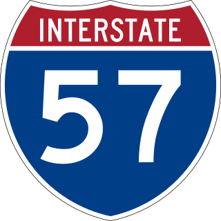
Interstate 57 (I-57) is a north–south Interstate Highway in Missouri and Illinois that parallels the old Illinois Central Railroad for much of its route. It runs from Sikeston, Missouri, at I-55 to Chicago, Illinois, at I-94. I-57 essentially serves as a shortcut route for travelers headed between the Southern U.S. and Chicago, bypassing St. Louis, Missouri, and Springfield, Illinois. Between the junction of I-55 and I-57 in Sikeston and the junction of I-55 and I-90/I-94 in Chicago, I-55 travels for 436 miles (702 km), while the combination of I-57 and I-94 is only 396 miles (637 km) long between the same two points. In fact, both the control cities on the overhead signs and the destination mileage signs reference Memphis along southbound I-57, even as far north as its northern origin at I-94 in Chicago. Likewise, at its southern end, Chicago is the control city listed for I-57 on signs on northbound I-55 south of Sikeston, even though I-55 also goes to Chicago. A southward extension of I-57 from its current southern terminus to Little Rock, Arkansas, is currently in various stages of development.

Interstate 49 (I-49) is a north–south Interstate Highway that exists in multiple segments: the original portion entirely within the state of Louisiana with an additional signed portion extending from I-220 in Shreveport to the Arkansas state line, three newer sections in Arkansas, and a new section that opened in Missouri. Its southern terminus is in Lafayette, Louisiana, at I-10 while its northern terminus is in Kansas City, Missouri, at I-435 and I-470. Portions of the remaining roadway in Louisiana, Arkansas, and Texas, which will link Kansas City with New Orleans, are in various stages of planning or construction.

Bellefonte is a town in Boone County, Arkansas, United States. The population was 530 at the 2010 census. It is part of the Harrison Micropolitan Statistical Area. Bellefonte gained national attention in 2013 when the city's mayor, James Wiggs, was recognized as the oldest active mayor in the United States at 90 years of age.

Pine Bluff is the 10th most populous city in the US state of Arkansas and the county seat of Jefferson County. It is the principal city of the Pine Bluff Metropolitan Statistical Area and part of the Little Rock-North Little Rock-Pine Bluff Combined Statistical Area. The population of the city was 41,253 in the 2020 census.

Fayetteville is the second-most populous city in the U.S. state of Arkansas, the county seat of Washington County, and the most populous city in Northwest Arkansas. The city had a population of 93,949 as of the 2020 census, which was estimated to have increased to 101,680 by 2023. The city is on the outskirts of the Boston Mountains, deep within the Ozarks. It was named after Fayetteville, Tennessee, from which many settlers had come, and was incorporated on November 3, 1836. Fayetteville is included in the three-county Fayetteville–Springdale–Rogers metropolitan statistical area, with 576,403 residents in 2020.

Rose Bud is a town in White County, Arkansas, in the United States. Rose Bud even with its small population is the fourth largest town in White County by area behind Beebe and Searcy. The demographics for the area are a majority Caucasian, then Hispanic being the second largest, followed by African-American, and Asian. A majority of the population by a small margin is between the age of 45 and 64. Rose Bud also has their own school district with Pre-K through 12th grade.

Interstate 555 (I-555) is an Interstate Highway that connects Turrell, Arkansas, at I-55 to Jonesboro at Highway 91 (AR 91). It provides a complete freeway corridor between Jonesboro, Arkansas's fifth-largest city, and Memphis, Tennessee. Formerly known as U.S. Highway 63 (US 63), the highway was converted in the early 21st century to Interstate Highway standards.

Route 101 is a short highway in southern Missouri. The route starts at Arkansas Highway 101 at the Arkansas–Missouri state line, and travels northeastward. It travels through the city of Bakersfield, intersecting Route 142. The road then continues north to its northern terminus at U.S. Route 160 in Caulfield. The route was designated in 1941, after a supplementary route was renumbered.
Jonathan Stark is a former professional tennis player from the United States. During his career he won two Grand Slam doubles titles. Stark reached the world No. 1 doubles ranking in 1994.
Robert D. Maurer is an American industrial physicist noted for his leadership in the invention of optical fiber.

Interstate 49 (I-49) is an Interstate Highway in the state of Arkansas. There are two main sections of the highway across different sides of the state. The southern section starts at the Louisiana state line, then runs to Texarkana, at the Texas state line. The northern section begins at I-40 and at U.S. Highway 71 (US 71) in Alma and runs north to the Missouri state line, where the freeway continues into Missouri. An additional small section south of Fort Smith is currently designated as Highway 549 until it is extended northward to the I-40 interchange, at which point it will become part of I-49.

Little Rock is the capital and most populous city of the U.S. state of Arkansas. The city's population was 202,591 as of the 2020 census. The six-county Little Rock metropolitan area is the 81st-most populous in the United States with 748,031 residents according to the 2020 census.

Sixteen special routes of U.S. Route 62 currently exist. Seven of them lie within the state of Arkansas. Three existed in the past but have since been decommissioned.

Center Township is one of 37 townships in Washington County, Arkansas, USA. At the 2010 census, its total population was 1,518.
Interstate 49 (I-49) is an Interstate Highway in the US state of Missouri that was designated on December 12, 2012. It overlaps U.S. Route 71 (US 71) in the western part of the state, beginning at the Arkansas state line, and ending at I-435 and I-470 on the southeast side of Kansas City.

The 1992 United States presidential election in Ohio took place on November 3, 1992, as part of the 1992 United States presidential election. Voters chose 21 representatives, or electors to the Electoral College, who voted for president and vice president.

The 1972 United States Senate election in New Hampshire took place on November 7, 1972. Incumbent Democratic Senator Thomas J. McIntyre won re-election to a third term. Democrats would not win this seat again until 2008. This was the first time Democrats were popularly re-elected to any Senate seat in New Hampshire.

Lee Philip Rudofsky is a United States district judge of the United States District Court for the Eastern District of Arkansas.
The Missouri and North Arkansas was a railroad in Missouri and Arkansas from 1906 to 1946.


