
Mountain View is a city in Santa Clara County, California, United States, in Silicon Valley. Named for its views of the Santa Cruz Mountains, Mountain View has developed from its origins as a stagecoach stop into one of the principal cities of Silicon Valley. It has a population of 74,066.

Wells is a town in Hamilton County, New York, United States. The population was 674 at the 2010 census. The town is named after Joshua Wells, a land agent, who built the first mills in the area. It is in the Adirondack Park and on the eastern border of the county. It is northwest of Schenectady.

Longs Peak is a high and prominent mountain summit in the northern Front Range of the Rocky Mountains of North America. The 14,259-foot (4346 m) fourteener is located in the Rocky Mountain National Park Wilderness, 9.6 miles (15.5 km) southwest by south of the Town of Estes Park, Colorado, United States. Longs Peak is the northmost "fourteener" in the Rocky Mountains and the highest point in Boulder County and Rocky Mountain National Park. The mountain was named in honor of explorer Stephen Harriman Long and is featured on the Colorado state quarter.

Yola, meaning 'Great Plain' or 'Vast Plain Land', is the largest city, capital city and administrative center of Adamawa State, Nigeria. Located on the Benue River, it has a population of 336,648 (2010). Yola is split into two parts. The old town of Yola where the Lamido resides is the traditional city but the new city of Jimeta is the administrative and commercial centre. Generally the term Yola is now used to mean both. To the north are the Mandara Mountains and the south are the Shebshi Mountains with Dimlang (Vogel) Peak the second highest point in Nigeria after Chappal Waddi. Yola is an access point to the Gashaka Gumpti Nature Reserve, which is the largest national park in Nigeria, the Ngel Nyaki montane forest reserve, the Mambilla Plateau, The Sukur UNESCO World heritage site, which is Africa's first cultural landscape to receive World Heritage List inscription, The Yadin Waterfalls, The Kiri Dam on the Gongola River, The Benue national park in nearby Cameroon, The Waza National Park, and Cameroonian town of Garoua, which lies across the border, on the Benue river.

Downhill mountain biking (DH) is a genre of mountain biking practiced on steep, rough terrain that often features jumps, drops, rock gardens and other obstacles.

Shoreline Amphitheatre is an outdoor amphitheater located in Mountain View, California, in the San Francisco Bay Area. The venue has a capacity of 22,500, with 6,500 reserved seats and 16,000 general admission on the lawn. When the parking lot is utilized for festival stages, the total capacity of the venue can reach 30,000.

Desert Center is a census designated place in the Colorado Desert in Riverside County, California. It is in southern California, between the cities of Indio and Blythe at the junction of Interstate 10 and State Route 177, about halfway between Phoenix and Los Angeles. The ZIP Code is 92239, and the community is in telephone area codes 442 and 760. The elevation is 656 feet (200 m). The population was 204 at the 2010 census.

Schooley's Mountain is an unincorporated community located within Washington Township in Morris County, New Jersey, United States. Named for the Schooley family who owned a considerable amount of land there in the 1790s, the community is on Schooley's Mountain, a mountain with an elevation of about 1,000 feet (300 m) directly north of Long Valley. It rises 600 feet (180 m) above the surrounding valley, located about 45 miles (72 km) from New York City. It contains many housing developments and Schooley's Mountain Park, a recreational area with an overlook, a waterfall, and numerous hiking paths, as well as Lake George. In its past, Schooley's Mountain was a resort and an estate.

Crestone Needle is a high mountain summit of the Crestones in the Sangre de Cristo Range of the Rocky Mountains of North America. The 14,203-foot (4,329 m) fourteener is located 6.9 miles (11.1 km) east-southeast of the Town of Crestone in Saguache County, Colorado, United States. The Crestones are a cluster of high summits in the Sangre de Cristo Range, comprising Crestone Peak, Crestone Needle, Kit Carson Peak, Challenger Point, Humboldt Peak, and Columbia Point. They are usually accessed from common trailheads.
Steve Douglas Cash was an American singer-songwriter and author, most notable as a founding and continual member of The Ozark Mountain Daredevils.

King of the Mountain is a 1981 American drama film starring Harry Hamlin, Joseph Bottoms, Deborah Van Valkenburgh, Richard Cox, Seymour Cassel and Dennis Hopper about a group that race their cars up and down Mulholland Drive for both money and prestige.

An ultra-prominent peak, or Ultra for short, is a mountain summit with a topographic prominence of 1,500 metres (4,900 ft) or more; it is also called a P1500. There are approximately 1,524 such peaks on Earth. Some well-known peaks, such as the Matterhorn and Eiger, are not Ultras because they are connected to higher mountains by high cols and therefore do not achieve enough topographic prominence.

The Howell Mountain AVA is an American Viticultural Area located within Napa Valley AVA of California.

The Glass House Mountains are a cluster of thirteen hills that rise abruptly from the coastal plain on the Sunshine Coast, Queensland, Australia. The highest hill is Mount Beerwah at 556 metres above sea level, but the most identifiable of all the hills is Mount Tibrogargan which from certain angles bears a resemblance to a face staring east towards the ocean. The Glass House Mountains are located near Beerburrum State Forest and Steve Irwin Way. From Brisbane, the mountains can be reached by following the Bruce Highway north and taking the Glass House Mountains tourist drive turn-off onto Steve Irwin Way. The trip is about one hour from Brisbane. The Volcanic peaks of the Glass House Mountains rise dramatically from the surrounding Sunshine Coast landscape. They were formed by intrusive plugs, remnants of volcanic activity that occurred 26-27 million years ago. Molten rock filled small vents or intruded as bodies beneath the surface and solidified into land rocks. Millions of years of erosion have removed the surrounding exteriors of volcanic cores and softer sandstone rock.

Mount Morgan is a mountain located in northwestern Inyo County, California, in the John Muir Wilderness of the Inyo National Forest.

Cornell is an unincorporated community in the Santa Monica Mountains, within western Los Angeles County, California. It is located 5 miles (8.0 km) west of Agoura Hills and around 2.5 miles (4.0 km) east of Malibu.
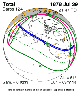
A total solar eclipse occurred on July 29, 1878, over much of North America including the region of the Rocky Mountains. A solar eclipse occurs when the Moon passes between Earth and the Sun, thereby totally or partly obscuring the image of the Sun for a viewer on Earth. A total solar eclipse occurs when the Moon's apparent diameter is larger than the Sun's, blocking all direct sunlight, turning day into darkness. Totality occurs in a narrow path across Earth's surface, with the partial solar eclipse visible over a surrounding region thousands of kilometres wide. This eclipse was visible at sunrise at a path across northeastern Asia and passed across Alaska, western Canada, and the United States from Montana through Texas. It then tracked across most of Cuba and southwestern Hispaniola before ending.

The Mountain States form one of the nine geographic divisions of the United States that are officially recognized by the United States Census Bureau. It is a subregion of the Western United States.

