
Arietta is a town in Hamilton County, New York, United States. The population was 304 at the 2010 census. The town was named after the mother of one of the first settlers, Rensselaer Van Rennslaer.

Indian Lake is a town in Hamilton County, New York, United States. The population was 1,352 at the 2010 census. The name is from a lake of the same name that is largely inside the town. There are no permanent stop lights in the town. Law enforcement is provided by New York State Troopers.

Wells is a town in Hamilton County, New York, United States. The population was 674 at the 2010 census. The town is named after Joshua Wells, a land agent, who built the first mills in the area. It is in the Adirondack Park and on the eastern border of the county. It is northwest of Schenectady.

Ohio is a town in Herkimer County, New York, United States. The population was 1,002 at the 2010 census. The town is named after the state of Ohio. The town is in the northern part of the county and northeast of Utica. Part of Ohio is within the Adirondack Park.
Walton is a town in Delaware County, New York, United States. The population was 5,576 at the 2010 census. The town is in the west-central part of the county and contains the village of Walton. The town claims to be the "Scarecrow Capital of the World."

The Inland Northwest or Inland Empire is a region of the Pacific Northwest centered on the Greater Spokane Area, that includes all of Eastern Washington and North Idaho. Western Montana is sometimes considered part of the Inland Northwest, but generally is not considered part of the Inland Empire. Under some definitions, the term Inland Empire also excludes Central Washington. As of 2016 the U.S. Census Bureau estimated the region's population at 2,240,645, comparable to that of New Mexico. Its Canadian counterpart, north of the border, is the British Columbia Interior. Significant urban centers include the Spokane–Coeur d'Alene area and the Tri-Cities.
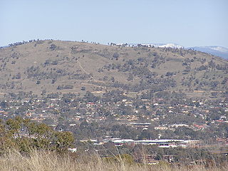
Mount Taylor is a prominent hill with an elevation of 856 metres (2,808 ft) AHD that is located between the Woden Valley, Weston Creek district and Tuggeranong Valley, in Canberra, within the Australian Capital Territory, Australia. Mount Taylor is part of the Canberra Nature Park and is surrounded by the suburbs of Kambah, Fisher, Waramanga, Chifley, Pearce, and Torrens. There are walking tracks to the peak. While there is no public road access to the peak there is a fire trail up the mountain from the end of Waldock St, Chifley where there is also a car park and picnic tables. The fire trail is normally closed to public vehicular access by locked gates, but the gates contain access points for walkers. The trail is especially popular with families and older walkers as it provides the easiest and most leisurely access to the peak. Originally a dirt road, it was partially sealed in 2009 on the steeper grades to make it safer for walkers and mountain bike riders.

Tiger Mountain is a mountain in the U.S. state of Washington.

Vly Mountain is a mountain located in the town of Halcott, New York, United States in Greene County. The mountain is part of the Catskill Mountains. Vly Mountain is flanked to the northwest by Bearpen Mountain, to the east by Vinegar Hill, to the northeast by Kipp Hill, and to the southeast by Beech Ridge.
Honwee Mountain, east summit 2,313 feet (705 m) and west summit 2,280 feet (690 m), is a prominent mountain in the Taconic Mountains of western Massachusetts. The mountain is located in Pittsfield State Forest. The east (highest) summit is traversed by the Honwee Circuit multi-use trail. The west summit is crossed by the 35 mi (56 km) Taconic Crest hiking trail and the 12.1 mi (19.5 km) multi-use Taconic Skyline Trail. The mountain is wooded with northern hardwood forest species.

Northwest Hills, sometimes referred to as Far West after its main street, is a suburb in the northwestern part of Austin, Texas, United States. The neighborhood is home to the largest concentration of Jewish residents in Austin, and includes a 40-acre complex housing a number of Jewish community organizations, synagogues, and schools.

Taylor Valley is the southernmost of the three large Dry Valleys in the Transantarctic Mountains, Victoria Land, located west of McMurdo Sound at approximately 77°37′S163°00′E. The valley extends from Taylor Glacier in the west to McMurdo Sound at Explorers Cove at the northwest head of New Harbour in the east and is about 29 kilometres (18 mi) long. It was once occupied by the receding Taylor Glacier, from which it derives its name. Taylor Valley contains Lake Bonney in the west (inward), and Lake Fryxell in the east (coastward), and Lake Hoare, Lake Chad, Lake Popplewell, Mummy Pond and Parera Pond close together between the two. Further east of Lake Bonney is Pearse Valley. Taylor Valley is separated from Wright Valley in the north by Asgard Range, and from Ferrar Glacier in the south by Kukri Hills.
Mountain Meadow Preserve is a 176-acre (71 ha) open space preserve located in the Berkshires and Green Mountains of northwest Massachusetts and adjacent Vermont in the towns of Williamstown and Pownal. The property, acquired in 1998 by the land conservation non-profit organization The Trustees of Reservations, includes highland meadows, wetlands, forested hills, and 4 miles (6.4 km) of trails.

The Buckskin Mountains, of Arizona, are a mountain range in west-central Arizona, USA. The range lies just east of the north-south Colorado River, and borders south of the east-west, west-flowing Bill Williams River.

The Black Hills of Yavapai County are a large mountain range of central Arizona in southeast Yavapai County. It is bordered by the Verde Valley to the east. The northwest section of the range is bisected from the southeast section by Interstate 17, which is the main route connecting Phoenix to Sedona, Oak Creek Canyon, and Flagstaff. This bisection point is the approximate center of the mostly northwest by southeast trending range. The northwest section contains a steep escarpment on the northeast with the Verde Valley, the escarpment being the location of the fault-block that created the historic mining district at Jerome.

The Black Hills of Greenlee County are a 20 mi (32 km) long mountain range of the extreme northeast Sonoran Desert bordering the south of the White Mountains of eastern Arizona's transition zone.
The Belmont Mountains are a 25 mi (40 km) long, arid, low elevation mountain range about 50 mi west of Phoenix, Arizona in the northern Sonoran Desert, north of the Gila River. The range is in the south of a region of two parallel washes; the Bouse Wash flows northwest to the Colorado River, and the Centennial Wash flows southeast to meet the Gila River.
The Date Creek Mountains are a short, arid range in southwest Yavapai County, Arizona. Congress is on its southeast foothills, and Wickenburg lies 15 mi (24 km) southeast.
Cherry Ridge is a mountain located in the Catskill Mountains of New York southeast of Hancock. Taylor Hill is located west, Big Fork Mountain is located north, and Rattlesnake Hill is located northwest of Cherry Ridge.


