Taylor Township, Blair County, Pennsylvania

Last updated

Taylor Township,
Blair County,
Pennsylvania
1804 - Taylor Twp - PA36 near PA867.JPG
Along Pennsylvania Route 36 in the township
Map of Taylor Township, Blair County, Pennsylvania Highlighted.png
Map of Blair County, Pennsylvania highlighting Taylor Township
Map of Pennsylvania highlighting Blair County.svg
Map of Blair County, Pennsylvania
Country United States
State Pennsylvania
County Blair
Settled1775
Incorporated1855
Government
  TypeBoard of Supervisors
Area
[1]
  Total23.34 sq mi (60.46 km2)
  Land23.34 sq mi (60.46 km2)
  Water0.00 sq mi (0.00 km2)
Population
 (2020) [2]
  Total2,296 Decrease2.svg
  Estimate 
(2022) [2]
2,261
  Density104.99/sq mi (40.54/km2)
Time zone UTC-5 (Eastern (EST))
  Summer (DST) UTC-4 (EDT)
Area code 814
FIPS code 42-013-76160

Taylor Township is a township in Blair County, Pennsylvania, United States. It is part of the Altoona, PA Metropolitan Statistical Area. The population was 2,296 at the 2020 census. [2]

Contents

General information

Geography

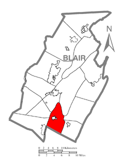
Taylor Township is located along the southern border of Blair County; Bedford County is to the south. The township completely surrounds the borough of Roaring Spring. The township's western border follows the ridgecrest of Dunning Mountain and Short Mountain, then curves to the east along the crest of Loop Mountain. Unincorporated places in the township include East Sharpsburg, Dumb Hundred, and Ore Hill.

According to the United States Census Bureau, the township has a total area of 23.4 square miles (60.5 km2), all land. [3]

Demographics

Historical population
CensusPop.Note
2010 2,465
2020 2,296−6.9%
2022 (est.)2,261 [2] −1.5%
U.S. Decennial Census [4]

According to the census [5] of 2000, there were 2,239 people, 852 households, and 685 families residing in the township. The population density was 96.8 inhabitants per square mile (37.4/km2). There were 909 housing units at an average density of 39.3 per square mile (15.2/km2). The racial makeup of the township was 98.84% White, 0.22% African American, 0.13% Asian, 0.18% from other races, and 0.63% from two or more races. Hispanic or Latino of any race were 0.36% of the population.

There were 852 households, out of which 30.5% had children under the age of 18 living with them, 72.3% were married couples living together, 5.0% had a female householder with no husband present, and 19.5% were non-families. 17.1% of all households were made up of individuals, and 8.6% had someone living alone who was 65 years of age or older. The average household size was 2.63 and the average family size was 2.95.

In the township the population was spread out, with 22.6% under the age of 18, 7.8% from 18 to 24, 27.4% from 25 to 44, 27.6% from 45 to 64, and 14.6% who were 65 years of age or older. The median age was 41 years. For every 100 females there were 106.2 males. For every 100 females age 18 and over, there were 101.5 males.

The median income for a household in the township was $41,635, and the median income for a family was $45,795. Males had a median income of $30,368 versus $23,438 for females. The per capita income for the township was $18,260. About 0.9% of families and 3.0% of the population were below the poverty line, including 3.0% of those under age 18 and 6.1% of those age 65 or over.

Recreation

A portion of Pennsylvania State Game Lands Number 147 is located on Dunning Mountain. [6] [7]

Related Research Articles

<span class="mw-page-title-main">Bedford Township, Pennsylvania</span> Township in Pennsylvania, United States

Bedford Township is a township in Bedford County, Pennsylvania, United States. The population was 5,107 at the 2020 census.

<span class="mw-page-title-main">Bloomfield Township, Bedford County, Pennsylvania</span> Township in Pennsylvania, United States

Bloomfield Township is a township in Bedford County, Pennsylvania, United States. The population was 1,039 at the 2020 census.

<span class="mw-page-title-main">Broad Top Township, Pennsylvania</span> Township in Pennsylvania, United States

Broad Top Township is a township in Bedford County, Pennsylvania, United States. The population was 1,441 at the 2020 census.

<span class="mw-page-title-main">South Woodbury Township, Pennsylvania</span> Township in Pennsylvania, United States

South Woodbury Township is a township in Bedford County, Pennsylvania, United States. The population was 2,083 at the 2020 census.

<span class="mw-page-title-main">Woodbury Township, Bedford County, Pennsylvania</span> Township in Pennsylvania, United States

Woodbury Township is a township that is located in Bedford County, Pennsylvania, United States. As of the 2020 census, the population was 1,180.

<span class="mw-page-title-main">Blair Township, Pennsylvania</span> Township in Pennsylvania, United States

Blair Township is a township in Blair County, Pennsylvania, United States. The population was 4,785 at the 2020 census.

<span class="mw-page-title-main">Catharine Township, Pennsylvania</span> Township in Pennsylvania, United States

Catharine Township is a township in Blair County, Pennsylvania, United States. The population was 773 at the 2020 census. It is part of the Altoona, PA Metropolitan Statistical Area.

<span class="mw-page-title-main">Frankstown Township, Blair County, Pennsylvania</span> Township in Pennsylvania, United States

Frankstown Township is a township in Blair County, Pennsylvania, United States. It is part of the Altoona Metropolitan Statistical Area. The population was 7,399 at the 2020 census. The township was named after Stephen Franks, a pioneer citizen.

<span class="mw-page-title-main">Freedom Township, Blair County, Pennsylvania</span> Township in Pennsylvania, United States

Freedom Township is a township in Blair County, Pennsylvania, United States. It is part of the Altoona, PA Metropolitan Statistical Area. The population was 3,005 at the 2020 census.

<span class="mw-page-title-main">Greenfield Township, Blair County, Pennsylvania</span> Township in Pennsylvania, United States

Greenfield Township is a township in Blair County, Pennsylvania, United States. It is part of the Altoona, PA Metropolitan Statistical Area. The population was 3,785 at the 2020 census.

<span class="mw-page-title-main">Huston Township, Blair County, Pennsylvania</span> Township in Pennsylvania, United States

Huston Township is a township in Blair County, Pennsylvania, United States. It is part of the Altoona, PA Metropolitan Statistical Area. The population was 1,247 at the 2020 census.

<span class="mw-page-title-main">Juniata Township, Blair County, Pennsylvania</span> Township in Pennsylvania, United States

Juniata Township is a township in Blair County, Pennsylvania, United States. It is part of the Altoona, PA Metropolitan Statistical Area. The population was 965 at the 2020 census.

<span class="mw-page-title-main">Logan Township, Blair County, Pennsylvania</span> Township in Pennsylvania, United States

Logan Township is a township in Blair County, Pennsylvania, United States. It is part of the Altoona, PA Metropolitan Statistical Area. It is the most populous township in Blair County, with a population of 12,413 at the 2020 census. Logan Township is home to Horseshoe Curve, a National Historic Landmark.

<span class="mw-page-title-main">North Woodbury Township, Pennsylvania</span> Township in Pennsylvania, United States

North Woodbury Township is a township in Blair County, Pennsylvania, United States. It is part of the Altoona, PA Metropolitan Statistical Area. The population was 2,434 at the 2020 census.

<span class="mw-page-title-main">Snyder Township, Blair County, Pennsylvania</span> Township in Pennsylvania, United States

Snyder Township is a township in Blair County, Pennsylvania, United States. It is part of the Altoona, PA Metropolitan Statistical Area. The population was 3,345 at the 2020 census.

<span class="mw-page-title-main">Tyrone Township, Blair County, Pennsylvania</span> Township in Pennsylvania, United States

Tyrone Township is a township in Blair County, Pennsylvania, United States. It is part of the Altoona, PA Metropolitan Statistical Area. The population was 1,873 at the 2020 census.

<span class="mw-page-title-main">Woodbury Township, Blair County, Pennsylvania</span> Township in Pennsylvania, United States

Woodbury Township is a township in Blair County, Pennsylvania, United States. It is part of the Altoona, PA Metropolitan Statistical Area. The population was 1,438 at the 2020 census.

<span class="mw-page-title-main">East Taylor Township, Cambria County, Pennsylvania</span> Township in Pennsylvania, United States

East Taylor Township is a township in Cambria County, Pennsylvania, United States, The population was 2,726 at the 2010 census, unchanged since the 2000 census. It is part of the Johnstown, Pennsylvania Metropolitan Statistical Area.

<span class="mw-page-title-main">Taylor Township, Centre County, Pennsylvania</span> Township in Pennsylvania, United States

Taylor Township is a township in Centre County, Pennsylvania, United States. It is part of the State College, Pennsylvania Metropolitan Statistical Area. The population was 853 at the 2020 census, no change from the figure tabulated in 2010.

<span class="mw-page-title-main">Adams Township, Snyder County, Pennsylvania</span> Township in Pennsylvania, United States

Adams Township in Snyder County, Pennsylvania, United States, is a township which had a population of 907 at the 2010 census. Per the US Census Bureau, by 2020 the population had reduced to 895 people.

References

  1. "2016 U.S. Gazetteer Files". United States Census Bureau. Retrieved August 13, 2017.
  2. 1 2 3 4 Bureau, US Census. "City and Town Population Totals: 2020-2022". Census.gov. US Census Bureau. Retrieved March 5, 2024.
  3. "Geographic Identifiers: 2010 Demographic Profile Data (G001): Taylor township, Blair County, Pennsylvania". U.S. Census Bureau, American Factfinder. Archived from the original on February 12, 2020. Retrieved March 12, 2014.
  4. "Census of Population and Housing". Census.gov. Retrieved June 4, 2016.
  5. "U.S. Census website". United States Census Bureau . Retrieved January 31, 2008.
  6. https://viewer.nationalmap.gov/advanced-viewer/ The National Map, retrieved November 14, 2018
  7. Pennsylvania State Game Lands Number 147, retrieved November 14, 2018

40°19′N78°25′W / 40.32°N 78.41°W / 40.32; -78.41