
The Adirondack Mountains form a massif in northeastern New York, United States. Its boundaries correspond roughly to the boundaries of Adirondack Park. The mountains form a roughly circular dome, about 160 miles (260 km) in diameter and about 1 mile (1,600 m) high. The current relief owes much to glaciation.

Arietta is a town in Hamilton County, New York, United States. The population was 304 at the 2010 census. The town was named after the mother of one of the first settlers, Rensselaer Van Rennslaer.

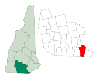
Benson is a town in Hamilton County, New York, United States. The population was 192 at the 2010 census. The town is on the south border of Hamilton County and is northwest of Schenectady. The current Town Supervisor is John M. Stortecky.

Indian Lake is a town in Hamilton County, New York, United States. The population was 1,352 at the 2010 census. The name is from a lake of the same name that is largely inside the town. There are no permanent stop lights in the town. Law enforcement is provided by New York State Troopers and Hamilton County Sheriff's Office.

Stansbury Park is a census-designated place (CDP) in Tooele County, Utah, United States. The population was 5,145 at the 2010 Census; it was 2,385 at the 2000 census; the 1990 census population was 1,049.
Hudson is a town in Hillsborough County, New Hampshire, United States. It is located along the Massachusetts state line. The population was 24,467 at the 2010 census, with an estimated population of 25,139 in 2017. It is the tenth-largest municipality in the state, by population.

Long Pond is an unincorporated community in Monroe County in the Pocono Mountains region of Pennsylvania, a part of the Appalachian Mountains. Its ZIP code is 18334.
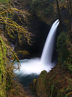
Eagle Creek is a creek located in Hood River County, Oregon, in the Columbia River Gorge. A tributary of the Columbia River, the creek flows for approximately 15 miles (24 km) from the Thrush Pond between Eagle Butte and Tanner Butte to its mouth near Bonneville Dam. The East Fork Eagle Creek is a major tributary that begins at Wahtum Lake and joins the main stem approximately 2/3 the way between the Thrush Pond and the Columbia River, separated by Indian Mountain.
Taconic State Park is located in Columbia and Dutchess County, New York abutting Massachusetts and Connecticut within the Taconic Mountains. The state park is located off New York State Route 344 south of Interstate 90 and 110 miles (180 km) north of New York City. It features camping, hiking, bicycling, hunting, cross county skiing and other recreational opportunities.

Savoy Mountain State Forest is a remote Massachusetts state forest located primarily in the towns of Savoy and Florida, with portions extending into neighboring Adams and North Adams. Situated along the Hoosac Mountain Range, it features four ponds, and seven hill and mountain summits, including Lewis Hill (2177 ft), Flat Rock Hill (2195 ft), Spruce Hill (2566 ft), and Borden Mountain (2505 ft). Also within the forest are at least two notable waterfalls, Parker Brook Falls and Tannery Falls, the latter of which is a 100-foot (30 m) drop. The forest is managed by the Department of Conservation and Recreation.

Moxie Falls is a waterfall in Somerset County, Maine. At a vertical drop of over 90 feet (30 m) into a pool about 17 feet (5 m) deep, Moxie Falls is one of the highest falls in New England. The falls are part of Moxie Stream which flows from Moxie Pond into the Kennebec River approximately 1 kilometer (0.62 mi) downstream the falls. Moxie Stream drains Moxie Pond approximately 5 miles (8.0 km) upstream of the falls.
The largest great pond in Maine named Great Pond is located in Kennebec County and is part of the Kennebec River watershed. There are several other, smaller ponds named Great Pond in Maine and New England. Great Pond is among the largest waterbodies in the world named "pond".

The Silver Lake Wilderness Area, an Adirondack Park unit of the Forest Preserve, is located in the towns of Lake Pleasant, Benson, Wells and Arietta in Hamilton County and is roughly bounded on the north by NY 8 and private lands near Piseco Lake, Oxbow Lake, Hamilton Lake, Sand Lake and Lake Pleasant; on the east by NY 30; on the south generally by the Hamilton County line; and on the west by NY 10, the West Branch of the Sacandaga River and the Piseco Outlet.

Saltonstall Mountain, also known as Saltonstall Ridge, with a high point of (est.) 320 feet (98 m) above sea level, is a traprock mountain ridge located 3 miles (5 km) east of New Haven, Connecticut and 1.75 miles (2.8 km) north of Long Island Sound. It is part of the Metacomet Ridge that extends from Long Island Sound near New Haven, Connecticut, north through the Connecticut River Valley of Massachusetts to the Vermont border. Saltonstall Mountain is known for its 100 foot (30 m) scenic cliff faces and sharp ridgeline, unique microclimate ecosystems, rare plant communities, and for Lake Saltonstall, a 3 miles (5 km) long by 0.3 miles (400 m) wide municipal reservoir nearly enclosed by the mountain. Saltonstall Mountain is traversed by a number of hiking trails managed by the South Central Connecticut Regional Water Authority (SCCRWA) and Branford Land Trust.
Berry Mountain, east peak 2,203 feet (671 m) and west peak 2,188 feet (667 m), is a prominent mountain in the Taconic Mountains of western Massachusetts. The mountain is located in Pittsfield State Forest. The west peak is traversed by the 35 mi (56 km) Taconic Crest hiking trail and the east peak is traversed by the 12.1 mi (19.5 km) multi-use Taconic Skyline Trail. The summits are mostly wooded with northern hardwood forest species, but also support a 65-acre (260,000 m2) field of wild azaleas. A microwave tower stands on the east peak. A park loop automobile road and a campground, maintained for summer use, are located just to the north of the summits. Berry Pond, 2,150 feet (660 m), presumed the highest natural pond in the state of Massachusetts, is located on the ridge between Berry Mountain and Berry Hill to the north.
Berry Hill, 2,200 feet (670 m), is a prominent mountain in the Taconic Mountains of western Massachusetts. The mountain is located in Pittsfield State Forest and is traversed by a short spur trail from a park automobile road. The Taconic Crest hiking trail and the multi-use Taconic Skyline Trail are located nearby. The mountain is known for its wild azalea fields. Its slopes are wooded with northern hardwood forest species. A park loop automobile road nearly encircles the summit, and a campground, maintained for summer use, is located just to the south of the summit. Berry Pond, 2,150 feet (660 m), presumed the highest natural pond in the state of Massachusetts, is located on the ridge between Berry Hill and Berry Mountain to the south.
Holy Mount, 1,968 feet (600 m), is a prominent peak in the Taconic Mountains of western Massachusetts, formerly used as the location of religious ceremonies by a nearby Shaker community.

Willard Pond is a small, protected lake in Antrim, New Hampshire, United States. The lake, located in southwestern New Hampshire, is about 108 acres (44 ha) in size with an average depth of 25 feet (7.6 m) and a maximum depth of 58 feet (18 m). No petroleum motors are allowed, and fly fishing is the only form of fishing allowed. It is part of the dePierrefeu Wildlife Sanctuary, which is owned by the New Hampshire Audubon Society. Because the pond and the land around it are part of the sanctuary, the shore is unable to be developed. Therefore, there are no buildings around the pond and there won't be in the foreseeable future. Willard is instead surrounded by extensive amounts of wilderness and hiking trails that lead around the pond and to the summits of Bald Mountain and Goodhue Hill. Willard is a popular fishing, boating and hiking destination, and it has become more popular with its mention in numerous magazines and newspapers.
Bomoseen State Park is a 3,576-acre state park in the towns of Castleton, Fair Haven, Hubbarton and Benson, Vermont. The park is located in the Taconic Mountains on the western shore of Lake Bomoseen.
The Shaker Mountain Wild Forest, an Adirondack Park unit of the Forest Preserve, is located in the towns of Northampton, Mayfield, Bleecker, and Caroga in Fulton County and the Town of Benson in Hamilton County. The southern terminus of the Northville-Placid Trail (NPT) is located at the trailhead in Waterfront Park in the Village of Northville.

