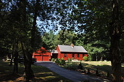
Saunderstown is a small village and historic district in the towns of Narragansett and North Kingstown in Washington County, Rhode Island, United States. Saunderstown has its own post office with the ZIP Code of 02874, which also includes a small part of South Kingstown. Its population is 6,245.

Swan Point Cemetery is a historic rural cemetery located in Providence, Rhode Island, United States. Established in 1846 on a 60-acre (0.24 km2) plot of land, it has approximately 40,000 interments.
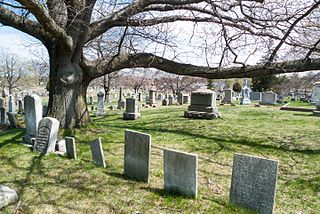
The North Burial Ground is a 110-acre (0.45 km2) cemetery in Providence, Rhode Island dating to 1700, the first public cemetery in Providence. It is located north of downtown Providence, bounded by North Main Street, Branch Avenue, the Moshassuck River, and Cemetery Street. Its main entrance is at the junction of Branch and North Main. The burial ground is one of the larger municipal cemeteries in Southern New England, and it accepts 220 to 225 burials per year.

Union Village or "Bank Village" is a village and historic district located in North Smithfield and Woonsocket, Rhode Island on Rhode Island Route 146A. Union Village developed because it was at the cross roads of old Great Road and Pound Hill Road.

Lime Rock (Limerock) is a village and historic district in Lincoln, Providence County, Rhode Island, United States, near Rhode Island Route 146. The village was named after the limestone quarries in the area, which started in the 17th century, and continue to the present where Conklin Limestone Company now operates. Because of the abundance of limestone in the area many houses had massive end chimneys and were called "stone enders," a distinctly Rhode Island style of architecture. The historic district includes 21 historically significant properties in an area extending from Wilbur Road, just west of its junction with Old Louisquisset Pike, eastward to Great Road, and then along Great Road as far as Simon Sayles Road. Among these properties are three quarries, and the ruins of three old lime kilns. It was listed on the National Register of Historic Places in 1974.
Tillinghast may refer to:

The Great Road Historic District is a historic district in Lincoln, Rhode Island, commemorating a portion of Rhode Island's oldest highway, dating back to 1683. Great Road served as the main connection between Providence, Hartford and Worcester during colonial times. The district includes a 0.6-mile (0.97 km) section of the road, which winds along the Moshassuck River between a junction with Breakneck Hill Road and another with Front Street. Notable historic properties along this stretch of road include the National Historic Landmark Eleazer Arnold House, a stone-ender built in 1687, which is now a museum operated by Historic New England, the 1812 Moffett Mill, the Israel Arnold House, and Hearthside, the 1810 home of Stephen Smith, who established the adjacent Butteryfly Mill in 1811.

The Smithfield Road Historic District is a rural historic district in North Smithfield, Rhode Island, along Old Smithfield Road. It extends along Old Smithfield Road north from its junction with Sayles Hill Road, and is roughly bisected by Spring Brook. It includes eight historic houses or farmsteads, two 19th-century cemeteries, and a dam on Spring Brook just east of the road. The district encompasses a cross-section of the development of agricultural properties in North Smithfield over the 19th century, with properties dating from 1811 to 1932. The district covers 170 acres (69 ha), which includes lands currently and formerly in agricultural use.

The Windmill Hill Historic District is a historic district encompassing a large rural landscape in Jamestown, Rhode Island. It is bounded on the north by Eldred Avenue, on the east by East Shore Road, on the south by Great Creek, and on the west by Narragansett Bay. The area's historical resources included six farmsteads, as well as the Quaker Meetinghouse, the Jamestown Windmill, and its associated miller's house and barn. The area is predominantly rolling hills with open pastureland and forest. The district was listed on the National Register of Historic Places in 1978. The area is also rich in prehistoric evidence of Native American occupation, which is the subject of the Jamestown Archeological District listing on the National Register.
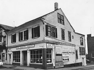
The Charles Tillinghast House was a historic house at 243–245 Thames Street in downtown Newport, Rhode Island. It was a 2+1⁄2-story timber-frame structure, with a side-gable roof, built around 1710–20. It was one of the oldest buildings in the city. It was probably built by Charles Tillinghast, whose family was among the founders of Rhode Island. The house had a distinctive cove-shaped plaster cornice, typically found on houses of this period. It was one of the first houses to be built on Thames Street.
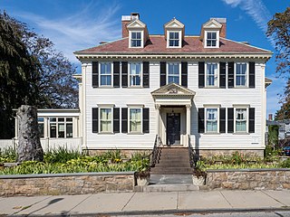
The John Tillinghast House is an historic colonial house in Newport, Rhode Island. It is a 2+1⁄2-story wood-frame structure, built in 1760 for John Tillinghast, a wealthy merchant. A high-quality example of academic Georgian architecture, the house was a home for a number of notable people during and after the American Revolutionary War. It was probably occupied by the Marquis de Chastellux, an engineer in the French Army while he was stationed in Newport, and by General Nathanael Greene, who hosted George Washington and the Marquis de Lafayette on a visit to Newport. From 1821 to 1824 it was home to William C. Gibbs while he was Governor of Rhode Island.

The Osborn–Bennett Historic District is a residential historic district in Tiverton, Rhode Island consisting of four houses. The district was added to the National Register of Historic Places in 2006.

The Andrews–Luther Farm is a historic farm in Scituate, Rhode Island. It is located on the south side of Elmdale Road, a short way east of its junction with Harmony Road. The farm is a 45-acre (18 ha) property, with its main house, a c. 1768 wood-frame structure set near the road. It is 2+1⁄2 stories high, with a large central chimney, and a center entry on the south facade with vernacular Greek Revival styling. A corn crib dating to the late 19th or early 20th century stands further south on the property, and the foundational remains of older buildings dot the area. The farm is distinctive for retaining a large portion of its original setting, and for the detailed accounts of it which have been retained by Harley Luther's descendants.

The Lippitt Hill Historic District is a historic district in Cranston, Rhode Island along Hope Road between Laten Knight Road and Hope Road's junction with Burlingame Road and Lippitt Avenue. This area was settled by Moses Lippitt, who in 1735 built a Georgian farmhouse for his son Christopher. Christopher later (1805) built a Federal style house for his son William. These two farmhouses are the anchors of this rural district, which also includes a historical cemetery in which many generations of Lippitts are buried, and which features a unique heart-shaped planting of pine trees.

Hopkinton City Historic District is a historic district encompassing the town center of Hopkinton, Rhode Island. The district is centered on the junction of Rhode Island Route 3 with Woodville Road, Clark Falls Road, Townhouse Road, and Old Rockville Road. It is a relatively modest town center, with twenty residences, two church buildings, the town hall, and post office. The most imposing house in the district is the Thurston-Wells House, a c. 1800 structure which was given a Victorian treatment in the mid-19th century; it stands opposite the 1836 Greek Revival First Baptist Church. The area was a major stop on the stagecoach route, and was eclipsed in the 20th century by the construction of Interstate 95, which passes nearby.
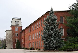
Lafayette Village is a historic district extending along Ten Rod Road in North Kingstown, Rhode Island. It encompasses a linear rural and industrial village, running from the Wickford Junction railroad crossing in the west to Angel Avenue in the east, and includes a number of residential properties on adjacent side streets. The centerpiece of the district is the Rodman Manufacturing Company complex, which operated here for a century beginning in the 1840s. The Robert Rodman Mansion, a Second Empire house with an elaborate porch, stands at 731 Ten Rod Road, and the Walter Rodman House, built in the 1870s, is even more elaborately decorated. Most of the residential stock in the district is mill-related housing built by the Rodmans for their workers.

The Forge Road Historic District is a historic district on Forge Road from Ives Road to the Potowomut River in Warwick, Rhode Island. Most of the district's nearly 200 acres (81 ha) are taken up by the Forge Farm, which lies south of Forge Road, is one of the oldest farms in Rhode Island, and was the birthplace of American Revolutionary War general Nathanael Greene. A memorial to Greene stands near the bridge crossing the Potowomut River. Opposite the farm on Forge Road stand four houses, all of which date to the late 18th to mid-19th century.

The Rice City Historic District is a historic district in Coventry, Rhode Island. It encompasses the 19th-century village of Rice City, extending along Plainfield Pike for several miles between Sisson Road and Gibson Hill Road in the northwestern part of Coventry. The main village center is at the junction of the Pike and Vaughn Hollow Road, and there is a former industrial and commercial center at Fairbank's Corner, the junction with Flat River Road. The architecture of the district is predominantly rural and residential, with Greek Revival and Federal style housing predominating. Rice City village is dominated by Rice Tavern, which used to serve travelers on their way to Connecticut, as well as the Rice City Church (1846), the Democrat Schoolhouse, and the Obadiah Potter House (1846), all a short way up Vaughn Hill Road. At the western edge of the district, the modern Pike alignment diverges from the historical one at Gibson Hill Road, where the foundational remnants of agricultural settlements may be found.

The Tillinghast Mill Site is an historic industrial site in East Greenwich, Rhode Island. The site is the location of a cotton mill established in 1812 most likely by Allin Tillinghast and Joseph Joslyn Tillinghast. The mill was more formally known as the Mount Hope Factory. The mill initially produced cotton yarn, but later made printed cloth, carpet, and twine. At its height the area included 25 mill worker houses as well as the waterworks, wood frame mill structure, and four story factory. The mill was in operation until at least 1905, but now only the foundational remnants of the mill and the waterworks remain.
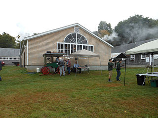
The New England Wireless and Steam Museum is an electrical and mechanical engineering museum at 1300 Frenchtown Road in East Greenwich, Rhode Island, with working steam engines and an early wireless station and technology archives.