Tipp City, Ohio

Last updated
Tipp City, Ohio
Old Tippecanoe Main Street Historic District 05.jpg
OHMap-doton-Tipp City.png
Location of Tipp City, Ohio
Map of Miami County Ohio Highlighting Tipp City City.png
Location of Tipp City in Miami County
Coordinates: 39°57′52″N84°11′12″W / 39.96444°N 84.18667°W / 39.96444; -84.18667
Country United States
State Ohio
County Miami
Government
   Mayor Joseph Gibson
Area
[1]
  Total8.18 sq mi (21.19 km2)
  Land8.03 sq mi (20.80 km2)
  Water0.15 sq mi (0.39 km2)
Elevation
[2]
886 ft (270 m)
Population
 (2020)
  Total10,274
  Density1,279.13/sq mi (493.90/km2)
Time zone UTC-5 (Eastern (EST))
  Summer (DST) UTC-4 (EDT)
ZIP code
45371
Area code(s) 937, 326
FIPS code 39-76876 [3]
GNIS feature ID2397027 [2]
Website http://www.tippcityohio.gov/

Tipp City is a city in southern Miami County, Ohio, United States, just outside Dayton. The population was 10,274 at the 2020 census. Originally known as Tippecanoe, and then Tippecanoe City, it was renamed to Tipp City in 1938 because another town in Ohio was likewise named Tippecanoe. The city lies in the Miami Valley and sits along Interstate 75 near the Interstate 70 interchange. Tipp City is part of the Dayton metropolitan area.

Contents

History

Tippecanoe City was founded in 1840 along the developing Miami and Erie Canal. Its name derives from Presidential candidate William Henry Harrison's nickname, Tippecanoe, which, in turn, was derived from his heroism at the Battle of Tippecanoe on November 7, 1811.

The early city was a popular stopping-off point for boatmen traveling along the Miami and Erie Canal. The original downtown purportedly included a large number of bars and a red light district. The now dry canal locks can be seen just east of downtown. As Tippecanoe City grew, it merged with Hyattsville, a contiguous village, located on present-day Hyatt Street. Development of the railroads in the 1850s and 1860s put the canals out of business and slowed the city's initially rapid growth. Ruins of a repair shop (yard barn) for the old Inter-Urban rail system can still be seen on the outskirts of town.

The U.S. Postal Service abbreviated the town's name in the 1930s to resolve a conflict with Tippecanoe, Ohio. [4] Tippecanoe High School retains the former full name of the city. The development of U.S. Route 25 (County Road 25-A) and subsequently Interstate 75 brought construction and vibrance back to the town throughout the 20th century.

On June 8, 2022, a tornado struck Tipp City, causing heavy damage to a Meijer distribution center in the area. The tornado strengthened just before hitting the city. This tornado traveled 13.9 miles before ending in Casstown, Ohio. This and 5 other tornadoes were part of a tornado outbreak in Ohio, which had 6 tornadoes strike the state.

Geography

Tipp City is located on the Miami River, approximately 10 miles north of Dayton and has direct highway access to Interstate 75.

According to the United States Census Bureau, the city has a total area of 7.64 square miles (19.79 km2), of which 7.53 square miles (19.50 km2) is land and 0.11 square miles (0.28 km2) is water. [5]

Demographics

Historical population
CensusPop.Note
1860 949
1870 1,20426.9%
1880 1,40116.4%
1890 1,4654.6%
1900 1,70316.2%
1910 2,03819.7%
1920 2,42619.0%
1930 2,5595.5%
1940 2,87912.5%
1950 3,30414.8%
1960 4,26729.1%
1970 5,09019.3%
1980 5,5959.9%
1990 6,0277.7%
2000 9,22153.0%
2010 9,6895.1%
2020 10,2746.0%
2021 (est.)10,3310.6%
Sources: [3] [6] [7] [8] [9] [10] [11] [12]

2010 census

As of the census [13] of 2010, there were 9,689 people, 3,861 households, and 2,685 families residing in the city. The population density was 1,286.7 inhabitants per square mile (496.8/km2). There were 4,194 housing units at an average density of 557.0 per square mile (215.1/km2). The racial makeup of the city was 95.9% White, 0.6% African American, 0.2% Native American, 1.5% Asian, 0.7% from other races, and 1.2% from two or more races. Hispanic or Latino of any race were 1.6% of the population.

There were 3,861 households, of which 35.5% had children under the age of 18 living with them, 54.3% were married couples living together, 11.0% had a female householder with no husband present, 4.2% had a male householder with no wife present, and 30.5% were non-families. 27.0% of all households were made up of individuals, and 11.7% had someone living alone who was 65 years of age or older. The average household size was 2.48 and the average family size was 3.01.

The median age in the city was 40.3 years. 25.9% of residents were under the age of 18; 7% were between the ages of 18 and 24; 24.2% were from 25 to 44; 27.9% were from 45 to 64; and 15% were 65 years of age or older. The gender makeup of the city was 48.2% male and 51.8% female.

2000 census

As of the census [3] of 2000, there were 9,221 people, 3,632 households, and 2,542 families residing in the city. The population density was 1,492.6 inhabitants per square mile (576.3/km2). There were 3,799 housing units at an average density of 615.0 per square mile (237.5/km2). The racial makeup of the city was 97.54% White, 0.25% African American, 0.23% Native American, 0.90% Asian, 0.39% from other races, and 0.69% from two or more races. Hispanic or Latino of any race were 1.20% of the population.

There were 3,632 households, out of which 36.9% had children under the age of 18 living with them, 56.6% were married couples living together, 9.6% had a female householder with no husband present, and 30.0% were non-families. 25.1% of all households were made up of individuals, and 10.7% had someone living alone who was 65 years of age or older. The average household size was 2.51 and the average family size was 3.02.

In the city the population was spread out, with 28.2% under the age of 18, 7.7% from 18 to 24, 30.1% from 25 to 44, 21.1% from 45 to 64, and 13.0% who were 65 years of age or older. The median age was 36 years. For every 100 females, there were 93.9 males. For every 100 females age 18 and over, there were 89.9 males.

The median income for a household in the city was $48,675, and the median income for a family was $62,991. Males had a median income of $44,917 versus $27,973 for females. The per capita income for the city was $24,118. About 3.8% of families and 5.2% of the population were below the poverty line, including 6.5% of those under age 18 and 2.4% of those age 65 or over.

Economy

Tipp City functions as a bedroom community north of Dayton, and includes light manufacturing, small business and family-owned restaurants, serving the local community and travelers along I-75.

Arts and culture

The cultural focus of Tipp City is largely based on high school and community-gathering events. In the fourth week of September each year, the city, in partnership with local garden center Spring Hill Nurseries, puts on the Mum Festival, the largest community event of the year, attracting visitors from neighboring towns and cities to the parade, car cruise in and festival grounds. Other community events include Canal Days (the third weekend in May), Independence Day fireworks, Tippecanoe High School "Red Devil" football games. The Miami County Visitors Bureau as well as the Tipp City Visitor's Bureau maintains a list of upcoming special events. [14] [15]

In past years, Tipp City has been home to the Trans Am Nationals Friday night "cruise in" during late August [16]

Parks and recreation

Staffed by four full-time employees, the Parks Division is responsible for the maintenance of City Park and Kyle Park as well as eight neighborhood parks and the Nature Center. Park facilities include tennis courts, basketball courts, swimming pool, athletic fields, picnic shelters, playground equipment, nature trails, driving range, batting cages, community canoe livery and boat ramp on the Great Miami River. City Park also is home to a historic structure called the "Roundhouse," a favorite spot for family picnics and reunions. Tipp-Monroe Community Services hosts a summer playground at the Roundhouse for eight weeks, while organizations such as the Mum Festival Committee utilize the facility for their annual events.

Tipp City Bike Trail

Currently finished, and was under construction, the Miami County Bike Trail will be Tipp City's addition to the Buckeye Trail. The Miami County Bike Trail will be a north–south paved trail that will stretch the length of Miami County, allowing bikers, hikers and hitchhikers to follow the path of the Great Miami River and Miami and Erie Canal. Starting at the Shelby county line, it will run through the south end of Piqua, Troy and Tipp City before meeting up with the Miami County Municipal Jail just south of Tipp City. The Tipp City portion of the trail will consist of three sections:

Government

Tipp City uses the council-manager government system. In this system, the mayor is the ceremonial head, selected by the council from among its members. The Council President is likewise selected and presides over each council meeting. The council chooses a City Manager, who holds administrative authority over the city government. Council members are selected on a nonpartisan, at-large ballot.

Education

Tipp City Exempted Village Schools serve the city proper and surrounding Monroe Township. The buildings are located on three campuses and serve Kindergarten through 12th grade. The MVCTC provides vocational training to secondary students. While Bethel Local Schools has a Tipp City mailing address, the school is not affiliated with Tipp City Exempted Village Schools in any form, and serves students from parts of Tipp City, Huber Heights and Bethel Township. [17]

Media

Newspapers

Online news resource

Internet radio

Public-access television

Media no longer in publication

Related Research Articles

<span class="mw-page-title-main">Dayton, Ohio</span> City in Ohio, United States

Dayton is a city in and the county seat of Montgomery County, Ohio, United States. A small part of the city extends into Greene County. As of the 2020 census, the city proper had a population of 137,644, making it the sixth-most populous city in Ohio. Dayton anchors the state's fourth-largest metropolitan area, the Dayton metropolitan area, which had 814,049 residents. Dayton is located within Ohio's Miami Valley region, 50 miles (80 km) north of Cincinnati and 60 miles (97 km) west of Columbus. It is a principal city of the Dayton–Springfield–Sidney combined statistical area, home to a population of 1,086,512.

<span class="mw-page-title-main">Montgomery County, Ohio</span> County in Ohio, United States

Montgomery County is located in the southwestern portion of the U.S. state of Ohio. As of the 2020 census, the population was 537,309, making it the fifth-most populous county in Ohio. The county seat is Dayton. The county was named in honor of Richard Montgomery, an American Revolutionary War general killed in 1775 while attempting to capture Quebec City, Canada. Montgomery County is part of the Dayton, Ohio Metropolitan Statistical Area.

<span class="mw-page-title-main">Warren County, Ohio</span> County in Ohio, United States

Warren County is a county located in the southwestern part of the U.S. state of Ohio. As of the 2020 census, the population was 242,337. Its county seat is Lebanon and largest city is Mason. The county is one of Ohio's most affluent, with the highest median income of the state's 88 counties. The county was established on May 1, 1803, from Hamilton County; it is named for Dr. Joseph Warren, a hero of the Revolution who sent Paul Revere and the overlooked William Dawes on their famous rides and who died at the Battle of Bunker Hill. Warren County is part of the Cincinnati, OH-KY-IN Metropolitan Statistical Area.

<span class="mw-page-title-main">Miami County, Ohio</span> County in Ohio, United States

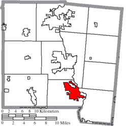
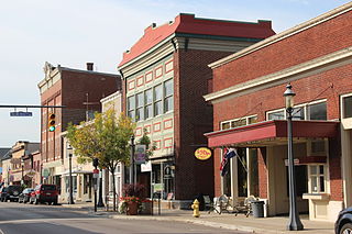
Miami County is a county located in the U.S. state of Ohio. As of the 2020 census, the population was 108,774. Its county seat is Troy. The county is named in honor of the Miami people.

<span class="mw-page-title-main">Greene County, Ohio</span> County in Ohio, United States

Greene County is located in the southwestern portion of Ohio. As of the 2020 census, the population was 167,966. Its county seat is Xenia and its largest city is Beavercreek. The county was established on March 24, 1803 and named for General Nathanael Greene, an officer in the Revolutionary War. Greene County is part of the Dayton, OH Metropolitan Statistical Area.

<span class="mw-page-title-main">Tippecanoe County, Indiana</span> County in Indiana, United States

Tippecanoe County is located in the west-central portion of the U.S. state of Indiana about 22 miles east of the Illinois state line and less than 50 miles from the Chicago and the Indianapolis metro areas. As of the 2020 census, the population was 186,251. The county seat and largest city is Lafayette. It was created in 1826 from Wabash County portion of New Purchase and unorganized territory.

<span class="mw-page-title-main">Park Layne, Ohio</span> Census-designated place in Ohio, United States

Park Layne is a census-designated place (CDP) in Bethel Township, Clark County, Ohio, United States. The population of the CDP was 4,248 at the 2020 census. It is part of the Springfield, Ohio Metropolitan Statistical Area. Park Layne became a CDP in the 1980 United States Census.

<span class="mw-page-title-main">Beavercreek, Ohio</span> City in Ohio, United States

Beavercreek is the largest city in Greene County, Ohio, United States. The population was 46,549 at the 2020 census. Part of the Dayton metropolitan area, it is the second-largest suburb of Dayton.

<span class="mw-page-title-main">Fairborn, Ohio</span> City in Ohio, United States

Fairborn is a city in Bath Township, Greene County, Ohio, United States. The population was 34,620 at the 2020 census. Fairborn is a suburb of Dayton, and part of the Dayton Metropolitan Statistical Area.

<span class="mw-page-title-main">Xenia, Ohio</span> City in Ohio, United States

Xenia is a city in and the county seat of Greene County, Ohio, United States. Located in southwestern Ohio, it is 15 miles (24 km) east of Dayton and is part of the Dayton metropolitan area as well as the Miami Valley region. As of the 2020 census, the city had a population of 25,441. The city's name comes from the Greek word Xenia (ξενία), which means "hospitality".

<span class="mw-page-title-main">Harrison, Ohio</span> City in Ohio, United States

Harrison is a city in western Hamilton County, Ohio, United States. The population was 12,563 at the 2020 census. It is part of the Cincinnati metropolitan area.

<span class="mw-page-title-main">Napoleon, Ohio</span> City in Ohio, United States

Napoleon is a city in and the county seat of Henry County, Ohio, United States, along the Maumee River 44 miles (71 km) southwest of Toledo. As of the 2020 census, the city had a total population of 8,862.

<span class="mw-page-title-main">Troy, Ohio</span> City and county seat of Miami County, Ohio

Troy is a city in and the county seat of Miami County, Ohio, United States, along the Great Miami River. The population was 26,305 at the 2020 census, making it Miami County's largest city and Ohio's 55th-largest. About 19 miles (31 km) north of Dayton, Troy is part of the Dayton metropolitan area.

<span class="mw-page-title-main">Miamisburg, Ohio</span> City in Ohio, United States

Miamisburg is a city in southern Montgomery County, Ohio, United States. The population was 19,923 at the 2020 census. A suburb of Dayton, it is part of the Dayton metropolitan area. Named after the Miami people, Miamisburg is known for its industrial history, particularly its nuclear operations during World War II, and retail factors such as the Dayton Mall and surrounding commercial business area.

<span class="mw-page-title-main">Moraine, Ohio</span> City in Ohio, United States

Moraine is a city in Montgomery County, Ohio, United States. Situated on the banks of the Great Miami River, Moraine is an inner suburb of Dayton, Ohio and a part of the Dayton metropolitan area. The population was 6,393 at the 2020 census.

<span class="mw-page-title-main">Trotwood, Ohio</span> City in Ohio, United States

Trotwood is a city in Montgomery County, Ohio, United States. The population was 23,070 at the 2020 census. A suburb of Dayton, it is part of the Dayton metropolitan area. The city is served by the Trotwood-Madison City School District.

<span class="mw-page-title-main">Vandalia, Ohio</span> City in Ohio, United States

Vandalia is a city in Montgomery County, Ohio, United States, and a suburb of Dayton. Its population was 15,209 during the 2020 census. In addition to being the city closest to Dayton International Airport, Vandalia lies at the crossroads of I-75 and I-70.

<span class="mw-page-title-main">Delphos, Ohio</span> City in Ohio, United States

Delphos is a city in Allen and Van Wert counties in the U.S. state of Ohio approximately 14 mi (23 km) northwest of Lima and 13 mi (21 km) east of Van Wert. The population was 7,117 at the 2020 census.

<span class="mw-page-title-main">Springboro, Ohio</span> City in Ohio, United States

Springboro is a city in the U.S. state of Ohio. A suburb of Cincinnati and Dayton, it is located mostly in Warren County in Clearcreek and Franklin Townships; with a small portion in Miami Township in Montgomery County. The city is part of the Miami Valley. As of the 2020 census, the city had a population of 19,062.

<span class="mw-page-title-main">Spring Hill, Kansas</span> City in Kansas, United States

Spring Hill is a city in Johnson and Miami counties in the U.S. state of Kansas, and part of the Kansas City Metropolitan Area. As of the 2020 census, the population of the city was 7,952.

References

  1. "ArcGIS REST Services Directory". United States Census Bureau. Retrieved September 20, 2022.
  2. 1 2 U.S. Geological Survey Geographic Names Information System: Tipp City, Ohio
  3. 1 2 3 "U.S. Census website". United States Census Bureau . Retrieved 2008-01-31.
  4. "History". VisitTippCity.org. Retrieved 2022-12-10.
  5. "US Gazetteer files 2010". United States Census Bureau. Archived from the original on 2012-01-25. Retrieved 2013-01-06.
  6. "Population of Civil Divisions Less than Counties" (PDF). Statistics of the Population of the United States at the Ninth Census. U.S. Census Bureau. 1870. Retrieved 17 May 2020.
  7. "Population of Civil Divisions Less than Counties" (PDF). Statistics of the Population of the United States at the Tenth Census. U.S. Census Bureau. 1880. Retrieved 17 May 2020.
  8. "Population: Ohio" (PDF). 1910 U.S. Census. U.S. Census Bureau. Retrieved 17 May 2020.
  9. "Population: Ohio" (PDF). 1930 US Census. U.S. Census Bureau. Retrieved 17 May 2020.
  10. "Number of Inhabitants: Ohio" (PDF). 18th Census of the United States. U.S. Census Bureau. 1960. Retrieved 17 May 2020.
  11. "Ohio: Population and Housing Unit Counts" (PDF). U.S. Census Bureau. Retrieved 17 May 2020.
  12. "Tipp City city, Ohio". census.gov. Retrieved July 6, 2022.
  13. "U.S. Census website". United States Census Bureau . Retrieved 2013-01-06.
  14. Miami County Visitors Bureau
  15. Tipp City Visitor's Bureau
  16. "Things to do in Dayton, OH | Events and more".
  17. "Welcome Information". Archived from the original on 2020-02-06. Retrieved 2020-02-06.
  18. TippNews DAILY
  19. "Get Social Radio online". Archived from the original on 2010-01-28. Retrieved 2010-01-20.