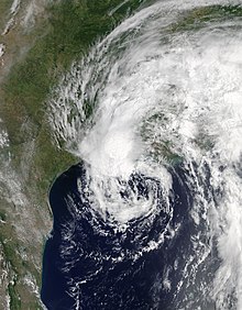
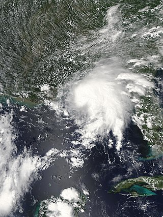
Hurricane Cindy was a tropical cyclone that made landfall in the U.S. state of Louisiana in July 2005. The third named storm of the 2005 Atlantic hurricane season, Cindy developed from a tropical wave on July 3, off the east coast of Mexico's Yucatán Peninsula. Soon after, it moved over land before emerging into the Gulf of Mexico. Cindy tracked toward the northern Gulf Coast and strengthened to reach maximum sustained winds of 75 mph (120 km/h), making it a Category 1 on the Saffir–Simpson scale. The hurricane struck near Grand Isle, Louisiana, on July 5 at peak intensity, but weakened by the time it made a second landfall along southern Mississippi. Cindy weakened over the southeastern United States and transitioned into an extratropical cyclone as it merged with a cold front on July 7. The remnants of Cindy produced an outbreak of 42 tornadoes across six states. Eventually, the remnants of Cindy moved into Atlantic Canada, dissipating on July 13 over the Gulf of St. Lawrence.
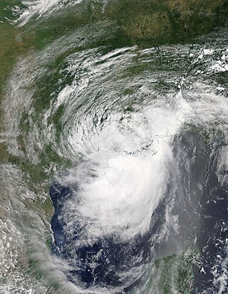
Tropical Storm Helene was a long-lived tropical cyclone that oscillated for ten days between a tropical wave and a 70 mph (110 km/h) tropical storm. It was the twelfth tropical cyclone and eighth tropical storm of the 2000 Atlantic hurricane season, forming on September 15 east of the Windward Islands. After degenerating into a tropical wave, the system produced flooding and mudslides in Puerto Rico. It reformed into a tropical depression on September 19 south of Cuba, and crossed the western portion of the island the next day while on the verge of dissipation. However, it intensified into a tropical storm in the Gulf of Mexico, reaching its peak intensity while approaching the northern Gulf Coast.
Tropical Storm Bertha was a minimal tropical storm that made landfall twice along the Gulf Coast of the United States in August 2002. The second tropical storm of the 2002 Atlantic hurricane season, Bertha developed in the northern Gulf of Mexico out of a trough of low pressure that extended into the Atlantic on August 4. It quickly organized and reached tropical storm strength before making landfall on southeastern Louisiana. Bertha turned to the southwest over the state, and re-entered the Gulf of Mexico on August 7. It remained disorganized due to proximity to land, and after making landfall on south Texas, Bertha dissipated on August 9.

Tropical Storm Fay was an unusual tropical storm that moved erratically across the state of Florida and the Caribbean Sea. The sixth named storm of the 2008 Atlantic hurricane season, Fay formed from a vigorous tropical wave on August 15 over the Dominican Republic. It passed over the island of Hispaniola, into the Gulf of Gonâve, across the island of Cuba, and made landfall on the Florida Keys late in the afternoon of August 18 before veering into the Gulf of Mexico. It again made landfall near Naples, Florida, in the early hours of August 19 and progressed northeast through the Florida peninsula, emerging into the Atlantic Ocean near Melbourne on August 20. Extensive flooding took place in parts of Florida as a result of its slow movement. On August 21, it made landfall again near New Smyrna Beach, Florida, moving due west across the Panhandle, crossing Gainesville and Panama City, Florida. As it zigzagged from water to land, it became the first storm in recorded history to make landfall in Florida four times. Thirty-six deaths were blamed on Fay. The storm also resulted in one of the most prolific tropical cyclone related tornado outbreaks on record. A total of 81 tornadoes touched down across five states, three of which were rated as EF2. Fay would cause around $560 million in damages throughout its lifespan.
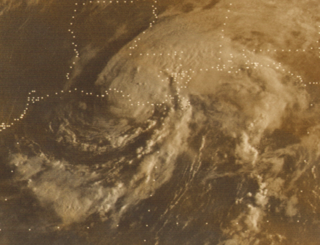
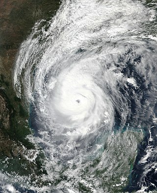
Hurricane Babe was the second named storm and the first to impact the United States during the inactive 1977 Atlantic hurricane season. Forming out of a tropical wave on September 3, Babe began as a subtropical cyclone in the eastern Gulf of Mexico. The storm gradually intensified as it tracked westward. On September 5, the storm turned north and acquired tropical characteristics. Later that day, Babe intensified into a hurricane and attained its peak strength with winds of 75 mph (120 km/h) and a barometric pressure of 995 mbar. Several hours later, the hurricane made landfall in Louisiana and quickly weakened. By September 6, Babe had weakened to a tropical depression and later dissipated early on September 9 over North Carolina.

Tropical Storm Bonnie was a small and rather weak tropical storm that brought squally weather to the northern Caribbean Sea and Gulf Coast of the United States in July 2010. The third tropical cyclone and second named storm of the 2010 Atlantic hurricane season, Bonnie developed from a tropical wave over the Bahamas on July 22. It strengthened to a tropical storm while crossing the islands, and made landfall on the southeastern coast of Florida the following day. Inland, Bonnie weakened to a tropical depression before entering the Gulf of Mexico, where its surface circulation dissipated on July 24. The remnants of the storm moved ashore between Louisiana and Mississippi early on July 25, prompting severe thunderstorm and tornado warnings in the area.

The 2017 Atlantic hurricane season was a devastating and extremely active Atlantic hurricane season that became the costliest on record, with a damage total of at least $294.92 billion (USD). The season featured 17 named storms, 10 hurricanes, and 6 major hurricanes. Most of the season's damage was due to hurricanes Harvey, Irma, and Maria. Another notable hurricane, Nate, was the worst natural disaster in Costa Rican history. These four storm names were retired following the season due to the number of deaths and amount of damage they caused. Collectively, the tropical cyclones were responsible for at least 3,364 deaths. The season also had the highest accumulated cyclone energy (ACE) since 2005 with an approximate index of 224 units, with a record three hurricanes each generating an ACE of over 40: Irma, Jose, and Maria. This season featured two Category 5 hurricanes, and the only season other than 2007 with two hurricanes making landfall at that intensity. The season's ten hurricanes occurred one after the other, the greatest number of consecutive hurricanes in the satellite era, and tied for the highest number of consecutive hurricanes ever observed in the Atlantic basin.

Tropical Storm Alberto was a destructive pre-season tropical cyclone which caused $125 million in damage in the Gulf Coast of the United States in May 2018, the costliest for any pre-season tropical cyclone. The first storm of the 2018 Atlantic hurricane season, Alberto developed on May 25 near the Yucatán Peninsula as a subtropical cyclone. As it entered the Gulf of Mexico, Alberto intensified and transitioned into a tropical cyclone. Early on May 28, Alberto reached its peak intensity, with maximum sustained winds of 65 mph (100 km/h) and a minimum pressure of 990 mbar. Afterward, however, dry air caused Alberto to weaken before it made landfall near Laguna Beach, Florida, with winds of 45 mph (75 km/h). Alberto maintained a compact area of thunderstorms as it progressed through the central United States, entering southern Michigan as a tropical depression on May 31. That day, Alberto weakened further and dissipated over Ontario.
Tropical Storm Gordon was a strong tropical cyclone that caused damage along the Gulf Coast of the United States in early September 2018. The seventh named storm of the 2018 Atlantic hurricane season, Gordon developed from a tropical wave that was first monitored in the Caribbean Sea on August 30. The wave moved west-northwestward toward the east coast of Florida while gradually organizing. The disturbance was marked as Potential Tropical Cyclone Seven on September 2 while near the Bahamas, and early the next day, it became Tropical Storm Gordon. The system made landfall on the southwest coast of Florida shortly afterwards. Steady intensification began after it moved off the coast of Florida and into the Gulf of Mexico. Gordon reached its peak intensity as a high-end tropical storm late on September 4 before making landfall just east of Pascagoula, Mississippi shortly afterwards. Gordon then rapidly weakened as it tracked inland, and degenerated into a remnant low on September 6. Gordon's remnants lingered over Arkansas for two days, before opening up into a low-pressure trough on September 8. At least three deaths were attributed to the storm, and Gordon caused approximately $200–250 million in damages.
Hurricane Barry was an asymmetrical tropical cyclone that was the wettest on record in Arkansas and the fourth-wettest in Louisiana. The second tropical or subtropical storm and first hurricane of the 2019 Atlantic hurricane season, Barry originated as a mesoscale convective vortex over southwestern Kansas on July 2. The system eventually emerged into the Gulf of Mexico from the Florida Panhandle on July 10, whereupon the National Hurricane Center (NHC) designated it as a potential tropical cyclone. Early on July 11, the system developed into a tropical depression, and strengthened into a tropical storm later that day. Dry air and wind shear caused most of the convection, or thunderstorms, to be displaced south of the center. Nevertheless, Barry gradually intensified. On July 13, Barry attained its peak intensity as Category 1 hurricane with 1-minute sustained winds of 75 mph (120 km/h) and a minimum central pressure of 993 millibars (29.3 inHg). At 15:00 UTC, Barry made its first landfall at Marsh Island, and another landfall in Intracoastal City, Louisiana, both times as a Category 1 hurricane. Barry quickly weakened after landfall, falling to tropical depression status on July 15. The storm finally degenerated into a remnant low over northern Arkansas on the same day, subsequently opening up into a trough on July 16. The storm's remnants persisted for another few days, while continuing its eastward motion, before being absorbed into another frontal storm to the south of Nova Scotia on July 19.

Tropical Storm Amanda and Tropical Storm Cristobal were two related, consecutive tropical cyclones that affected Central America, southern Mexico, the Central United States, and Canada in late May and early June 2020. The first tropical cyclone formed in the East Pacific and was named Amanda. After crossing Central America, it regenerated into a second one in the Gulf of Mexico and was named Cristobal. Amanda was the second tropical depression and the first named storm of the 2020 Pacific hurricane season, and Cristobal was the third named storm of the extremely active 2020 Atlantic hurricane season, and the earliest third named storm in the North Atlantic Ocean on record. Cristobal's regeneration date in the North Atlantic eclipsed the date set by Tropical Storm Colin in 2016, which formed on June 5. It was also the first Atlantic tropical storm formed in the month of June since Cindy in 2017, and the first June tropical cyclone to make landfall in Mexico since Danielle in 2016.

Hurricane Marco was the first of two tropical cyclones to threaten the Gulf Coast of the United States within a three-day period. The thirteenth named storm and third hurricane of the record-breaking 2020 Atlantic hurricane season, Marco developed from a fast-moving tropical wave west of the Windward Islands and south of Jamaica on August 20. The fast motion of the wave inhibited intensification initially, but as the wave slowed down and entered a more favorable environment, the system developed into a tropical depression, which in turn rapidly intensified into a strong tropical storm. Due to strong wind shear, Marco's intensification temporarily halted. However, after entering the warm waters of the Gulf of Mexico on August 23, Marco briefly intensified into a hurricane, only to quickly weaken later that evening due to another rapid increase in wind shear. Marco subsequently weakened to a tropical depression before degenerating into a remnant low early the next morning. Marco's remnants subsequently dissipated on August 26.

Hurricane Sally was a destructive and slow-moving tropical cyclone that was the first hurricane to make landfall in the U.S. state of Alabama since Ivan in 2004, coincidentally on the same date in the same place. The eighteenth named storm and seventh hurricane of the extremely active 2020 Atlantic hurricane season, Sally developed from an area of disturbed weather which was first monitored over the Bahamas on September 10. The system grew a broad area of low-pressure on September 11, and was designated as a tropical depression late that day. Early the next day, the depression made landfall at Key Biscayne and subsequently strengthened into Tropical Storm Sally that afternoon. Moderate northwesterly shear prevented significant intensification for the first two days, but convection continued to grow towards the center and Sally slowly intensified. On September 14, a center reformation into the center of the convection occurred, and data from a hurricane hunter reconnaissance aircraft showed that Sally had rapidly intensified into a strong Category 1 hurricane. However, an increase in wind shear and upwelling of colder waters halted the intensification and Sally weakened slightly on September 15 before turning slowly northeastward. Despite this increase in wind shear, it unexpectedly re-intensified, reaching Category 2 status early on September 16 before making landfall at peak intensity at 09:45 UTC on September 16, near Gulf Shores, Alabama, with maximum sustained winds of 110 mph (180 km/h) and a minimum central pressure of 965 millibars (28.5 inHg). The storm rapidly weakened after landfall before transitioning into an extratropical low at 12:00 UTC the next day. Sally's remnants lasted for another day as they moved off the coast of the Southeastern United States before being absorbed into another extratropical storm on September 18.

Tropical Storm Beta was a tropical cyclone that brought heavy rainfall, flooding, and severe weather to the Southeastern United States in September 2020. The twenty-third tropical depression and twenty-third named storm of the record-breaking 2020 Atlantic hurricane season, Beta originally formed from a trough of low pressure that developed in the northeastern Gulf of Mexico on September 10. The low moved slowly southwestward, with development hampered initially by the development of nearby Hurricane Sally. After Sally moved inland over the Southeastern United States and weakened, the disturbance became nearly stationary in the southwestern Gulf, where it began to organize. By September 16, the storm had gained a low-level circulation center and had enough organization to be designated as Tropical Depression Twenty-Two. The system held its intensity for a day due to the influence of strong wind shear and dry air, before eventually attaining tropical storm strength. It slowly moved northward and intensified to a mid-range tropical storm before dry air and wind shear halted its intensification. Beta then became nearly stationary on September 19, before starting to move west towards the Texas coast the next day, weakening as it approached. On September 21, Beta made landfall near Matagorda Peninsula, Texas as a minimal tropical storm. It subsequently weakened to a tropical depression the next day before becoming post-tropical early on September 23. Its remnants moved northeastward, before the center elongated and merged with a cold front early on September 25.

Hurricane Gamma was a tropical cyclone that brought heavy rains, flooding, and landslides to the Yucatán Peninsula in early October 2020. The twenty-fifth depression, twenty-fourth named storm and ninth hurricane of the extremely active 2020 Atlantic hurricane season, Gamma developed from a vigorous tropical wave that had been monitored as it was entering the Eastern Caribbean on September 29. The wave moved westward and slowed down as it moved into the Western Caribbean, where it began to interact with a dissipating cold front. A low formed within the disturbance on October 1 and the next day, it organized into a tropical depression. It further organized into Tropical Storm Gamma early the next day. It continued to intensify and made landfall as a minimal hurricane near Tulum, Mexico, on October 3. It weakened over land before reemerging in the Gulf of Mexico. Gamma then briefly restrengthened some before being blasted by high amounts of wind shear, causing it to weaken again. It made a second landfall as a tropical depression in Nichili, Mexico on October 6 before dissipating as it was absorbed by the approaching Hurricane Delta.
Hurricane Delta was a destructive tropical cyclone that became the record-tying fourth named storm of 2020 to make landfall in Louisiana, as well as the record-breaking tenth named storm to strike the United States in that year. The twenty-sixth tropical cyclone, twenty-fifth named storm, tenth hurricane, and third major hurricane of the record-breaking 2020 Atlantic hurricane season, Delta formed from a tropical wave which was first monitored by the National Hurricane Center (NHC) on October 1. Moving westward, the tropical wave began to quickly organize. A well-defined center of circulation formed with sufficiently organized deep convection on October 4, and was designated as Tropical Depression Twenty-six and soon thereafter, Tropical Storm Delta. Extremely rapid intensification ensued throughout October 5 into October 6, with Delta becoming a Category 4 hurricane within 28 hours of attaining tropical storm status. The rate of intensification was the fastest in the Atlantic basin since Hurricane Wilma in 2005. After peaking in intensity however, an unexpected increase in wind shear and dry air quickly weakened the small storm before it made landfall in Puerto Morelos, Mexico as a Category 2 hurricane with 105 mph (169 km/h) winds. It weakened some more over land before emerging into the Gulf of Mexico, where it was downgraded to a Category 1 hurricane. After that, it began to restrengthen, regaining Category 3 status late on October 8. It then turned northward and reached a secondary peak intensity of 953 mbar (28.14 inHg) and winds of 120 mph early on October 9. Delta then began to turn more north-northeastward into an area of cooler waters, higher wind shear, and dry air, causing it to weaken back to Category 2 status. Delta then made landfall at 23:00 UTC near Creole, Louisiana with winds of 100 mph (160 km/h) and a pressure of 970 mbar (29 inHg). The storm began to weaken more rapidly after landfall, becoming post-tropical just 22 hours later.

Tropical Storm Claudette was a weak tropical cyclone that caused heavy rain and tornadoes across the Southeastern United States in June 2021, leading to severe damage. The third named storm of the 2021 Atlantic hurricane season, Claudette originated from a broad trough of low pressure over the Bay of Campeche on June 12. The disturbance moved erratically over the region for the next several days, before proceeding northward with little development due to unfavorable upper-level winds and land interaction. Despite this, the National Hurricane Center (NHC) initiated advisories on it as a Potential Tropical Cyclone late on June 17, due to its imminent threat to land. The disturbance finally organized into Tropical Storm Claudette at 00:00 UTC on June 19 just before landfall in southeast Louisiana. Claudette weakened to a depression as it turned east-northeastward before moving through Mississippi, Alabama, Georgia, and South Carolina. Baroclinic forcing then caused Claudette to reintensify into a tropical storm over North Carolina early on June 21 before it accelerated into the Atlantic Ocean later that day. Soon afterward, it degenerated into a low-pressure trough on the same day, before being absorbed into another extratropical cyclone on the next day.

Tropical Storm Danny was a weak and short-lived tropical cyclone that caused minor damage to the U.S. states of South Carolina and Georgia. The fourth named storm of the 2021 Atlantic hurricane season, the system formed from an area of low-pressure that developed from an upper-level trough over the central Atlantic Ocean on June 22. Moving west-northwestward, the disturbance gradually developed as convection, or showers and thunderstorms, increased over it. Although it was moving over the warm Gulf Stream, the organization of the disturbance was hindered by strong upper-level wind shear. By 18:00 UTC of June 27, as satellite images showed a well-defined center and thunderstorms, the system was upgraded to a tropical depression by the National Hurricane Center (NHC). At 06:00 UTC on the next day, the system further strengthened into Tropical Storm Danny east-southeast of Charleston, South Carolina. Danny continued its track towards South Carolina while slowly strengthening, subsequently reaching its peak intensity at that day of 45 mph (72 km/h) and a minimum central pressure of 1,009 mbar (29.8 inHg) at 18:00 UTC. Danny then made landfall in Pritchards Island, north of Hilton Head, in a slightly weakened state at 23:20 UTC on the same day, with winds of 40 mph (64 km/h) and indicating that Danny weakened prior to moving inland. The system then weakened to a tropical depression over east-central Georgia, before dissipating shortly afterward.

Hurricane Francine was a moderately strong tropical cyclone that brought extensive flooding to parts of the Gulf Coast of the United States, especially Louisiana in September 2024. The sixth named storm and fourth hurricane of the 2024 Atlantic hurricane season, its formation brought the end to a significant quiet period in tropical cyclone formation in the Atlantic. Originating from a tropical wave that was initially spotted in the central Atlantic by the National Hurricane Center (NHC) in late August, the disturbance that eventually became Francine began gradually organizing on September 7 as it exited the Yucatan Peninsula into the Bay of Campeche. The disturbance consolidated further and was designated by the NHC as Potential Tropical Cyclone Six on September 8. The next day, it was upgraded to tropical storm status and was named Francine by the NHC. It made landfall in Louisiana on September 11, 2024 as a Category 2 hurricane with wind speeds of 100 mph (161 km/h), which left moderate damage in Louisiana and Mississippi. Afterward, it quickly weakened into a tropical storm on September 12, then a tropical depression the following day. Francine dissipated on September 14.