
The 2012 Pacific typhoon season was a slightly above average season that produced 25 named storms, fourteen typhoons, and four intense typhoons. It was a destructive and the second consecutive year to be the deadliest season, primarily due to Typhoon Bopha which killed 1,901 people in the Philippines. It was an event in the annual cycle of tropical cyclone formation, in which tropical cyclones form in the western Pacific Ocean. The season ran throughout 2012, though most tropical cyclones typically develop between May and October. The season's first named storm, Pakhar, developed on March 28, while the season's last named storm, Wukong, dissipated on December 29. The season's first typhoon, Guchol, reached typhoon status on June 15, and became the first super typhoon of the year on June 17.

The 2013 Pacific typhoon season was the most active Pacific typhoon season since 2004, and the deadliest since 1975. It featured Typhoon Haiyan, one of the most powerful storms and one of the strongest landfalling tropical cyclones in history. It was an above-average season with 31 named storms, 13 typhoons, and five super typhoons. The season's first named storm, Sonamu, developed on January 4 while the season's last named storm, Podul, dissipated on November 15. Despite the activity, most of the first seventeen named storms before mid-September were relatively weak, as only two of them reached typhoon intensity. Total damage amounted to at least $26.41 billion (USD), making it at the time the costliest Pacific typhoon season on record; it is currently the fourth costliest, behind the 2018, 2019 and 2023 seasons.

The 2015 Pacific typhoon season was a slightly above average season that produced twenty-seven tropical storms, eighteen typhoons, and nine super typhoons. The season ran throughout 2015, though most tropical cyclones typically develop between May and November. The season's first named storm, Mekkhala, developed on January 15, while the season's last named storm, Melor, dissipated on December 17. The season saw at least one named tropical system forming in each of every month, the first time since 1965. Similar to the previous season, this season saw a high number of super typhoons. Accumulated cyclone energy (ACE) during 2015 was extremely high, the third highest since 1970, and the 2015 ACE has been attributed in part to anthropogenic warming, and also the 2014-16 El Niño event, that led to similarly high ACE values in the East Pacific.

The 2016 Pacific typhoon season is considered to have been the fourth-latest start for a Pacific typhoon season since reliable records began. It was an average season, with a total of 26 named storms, 13 typhoons, and six super typhoons. The season ran throughout 2016, though typically most tropical cyclones develop between May and October. The season's first named storm, Nepartak, developed on July 3, while the season's last named storm, Nock-ten, dissipated on December 28.

The 2017 Pacific typhoon season was a below-average season in terms of accumulated cyclone energy and the number of typhoons and super typhoons, and the first since the 1977 season to not produce a Category 5-equivalent typhoon on the Saffir–Simpson scale. The season produced a total of 27 named storms, 11 typhoons, and only two super typhoons, making it an average season in terms of storm numbers. It was an event in the annual cycle of tropical cyclone formation, in which tropical cyclones form in the western Pacific Ocean. The season runs throughout 2017, though most tropical cyclones typically develop between May and October. The season's first named storm, Muifa, developed on April 25, while the season's last named storm, Tembin, dissipated on December 26. This season also featured the latest occurrence of the first typhoon of the year since 1998, with Noru reaching this intensity on July 23.

The 2018 Pacific typhoon season was at the time, the costliest Pacific typhoon season on record, until the record was beaten by the following year. The season was well above-average, producing twenty-nine storms, thirteen typhoons, seven super typhoons and six Category 5 tropical cyclones. The season ran throughout 2018, though most tropical cyclones typically develop between May and October. The season's first named storm, Bolaven, developed on January 3, while the season's last named storm, Man-yi, dissipated on November 28. The season's first typhoon, Jelawat, reached typhoon status on March 29, and became the first super typhoon of the year on the next day.
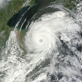
Typhoon Damrey was a compact tropical cyclone, which became the strongest to affect the area north of the Yangtze River since 1949. It was the tenth named storm and the fifth typhoon of the 2012 Pacific typhoon season. The name Damrey means elephant in Khmer, the official language of Cambodia.

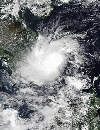
Typhoon Son-Tinh, known in the Philippines as Tropical Storm Ofel, was a powerful, late-forming typhoon that devastated the Philippines with tropical storm strength, and battered Northern Vietnam with hurricane-force winds at landfall on October 28, 2012. Originating from a broad area of low pressure over Palau on October 20, the system strengthened into a tropical depression by October 21, and on October 22, it became the 23rd named storm of the season.
Severe Tropical Storm Rumbia, known in the Philippines as Tropical Storm Gorio, was a tropical cyclone that brought widespread flooding in areas of the Philippines and China late June and early July 2013. The sixth internationally named storm of the season, Rumbia formed from a broad area of low pressure situated in the southern Philippine Sea on June 27. Steadily organizing, the initial tropical depression moved towards the northwest as the result of a nearby subtropical ridge. On June 28, the disturbance strengthened to tropical storm strength, and subsequently made its first landfall on Eastern Samar in the Philippines early the following day. Rumbia spent roughly a day moving across the archipelago before emerging into the South China Sea. Over open waters, Rumbia resumed strengthening, and reached its peak intensity with winds of 95 km/h (50 mph) on July 1, ranking it as a severe tropical storm. The tropical cyclone weakened slightly before moving ashore the Leizhou Peninsula late that day. Due to land interaction, Rumbia quickly weakened into a low pressure area on July 2 and eventually dissipated soon afterwards.
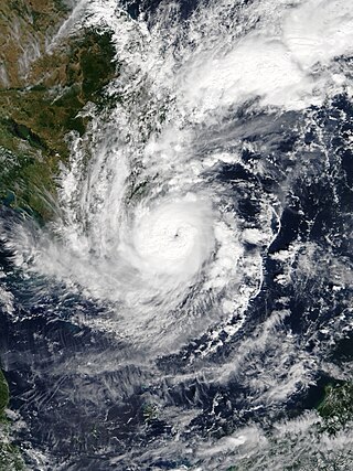
Typhoon Utor, known in the Philippines as Super Typhoon Labuyo, was a powerful, deadly and destructive tropical cyclone that struck the Philippines and southern China. Utor, contributed by United States for squall line, the 15th depression, the 2nd typhoon and the first super typhoon in the 2013 Pacific typhoon season. Utor started originating near Yap, tracking westwards in a favorable development, allowing the system to be better organized. All agencies have upgraded the system as a depression, with JTWC designated as Tropical Depression 11W and PAGASA naming the depression as Labuyo. Continuing westwards, JMA named 11W as Utor as it continues to consolidate.
This timeline documents all of the events of the 2012 Pacific typhoon season. The scope of this article is limited to the Pacific Ocean, north of the equator between 100°E and the International Date Line. During the season, 34 systems were designated as tropical depressions by either the Japan Meteorological Agency (JMA), the Philippine Atmospheric, Geophysical and Astronomical Services Administration (PAGASA), the Joint Typhoon Warning Center (JTWC), or other National Meteorological and Hydrological Services such as the China Meteorological Administration and the Hong Kong Observatory. Since the JMA runs the Regional Specialized Meteorological Centre (RSMC) for the Western Pacific, they assigned names to tropical depressions which developed into tropical storms in the basin. PAGASA also assigned local names to systems which are active in their area of responsibility; however, these names are not in common use outside of the Philippines.
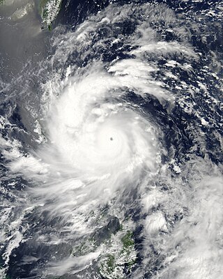
Typhoon Nangka was a large and powerful tropical cyclone that impacted central Japan in mid-July 2015. Nangka started its long-living journey as a tropical disturbance over the Marshall Islands and west of the International Dateline, becoming the eleventh named storm of the annual typhoon season on July 3. It quickly intensified while moving to the west-northwest, attaining typhoon status on July 6. Nangka moved through the Northern Marianas Islands, passing directly over the uninhabited island of Alamagan. Shortly thereafter, the typhoon attained peak winds; the Japan Meteorological Agency (JMA) estimated 10‑minute sustained winds of 185 km/h (115 mph), while the unofficial Joint Typhoon Warning Center (JTWC) estimated 1‑minute winds of 250 km/h (155 mph), making it a super typhoon. Nangka later weakened as it curved to the north, moving across central Japan on July 16 as a minimal typhoon. The storm weakened soon after, dissipating in the Sea of Japan on July 18.

Severe Tropical Storm Aere, known in the Philippines as Tropical Storm Julian, was a long-lived tropical cyclone that struck Central Vietnam in October 2016. The nineteenth named storm of the annual typhoon season, Aere formed on October 4, 2016 as a tropical depression to the east of Luzon, Philippines shortly after the JMA had started tracking Songda. On the next day, the system had become a tropical storm and it moved into South China Sea. During October 7, it intensified into a severe tropical storm and reached peak intensity with 10-minute winds of 110 km/h (70 mph). Shortly thereafter, due to remaining in almost the same area for hours, Aere began to weaken to a tropical storm, and on October 10, it weakened to a tropical depression, before weakening to a low-pressure area late on October 11. On October 13, Aere re-generated into a tropical depression and it made landfall in Huế, Vietnam late that day. The system moved towards Laos and Thailand before it fully dissipated on October 14.

Severe Tropical Storm Talas was a tropical cyclone that impacted Vietnam during mid July 2017. Talas was first tracked as a tropical disturbance over in the South China Sea on July 13, and was upgraded to a tropical depression during the next day. The depression intensified into the fourth named storm of the 2017 Pacific typhoon season during July 15. Before making landfall in Vietnam, Talas reached its peak intensity as a severe tropical storm during July 16. Talas weakened to an area of low pressure on July 17 inland.

Typhoon Nesat, known in the Philippines as Typhoon Gorio, was a strong tropical cyclone that impacted Taiwan and Fujian, China. It was the ninth named storm and the second typhoon of the annual typhoon season. After consolidating slowly for several days, Tropical Storm Nesat developed east of the Philippines on July 25. While experiencing favorable environmental conditions such as very warm sea surface temperatures and low wind shear, Nesat strengthened into a typhoon and reached its peak intensity on July 28. On July 29, the typhoon made landfall near the Taiwanese city of Yilan, before weakening to a severe tropical storm and making landfall again near Fuqing on China's east coast late the same day. Moving into July 30, Nesat continued to weaken under the effects of land interaction.

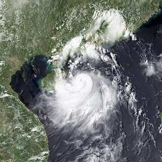
Typhoon Damrey, known in the Philippines as Severe Tropical Storm Ramil, was a strong tropical cyclone that affected the Philippines and Vietnam during early November 2017. Damrey first originated as a tropical depression over the Philippine archipelago of Visayas on October 31. Emerging into the South China Sea a few days later, the system strengthened into the second deadliest and twenty-third named storm of the 2017 Pacific typhoon season. Rapidly intensifying, Damrey became the season's tenth typhoon on November 3, reaching its peak intensity as a Category 2 on the same day. Damrey made landfall over Khánh Hoà, Vietnam on November 4 and began to rapidly weaken, fully dissipating on November 5.

The 2021 Pacific typhoon season was the second consecutive to have below average tropical cyclone activity, with twenty-two named storms, and was the least active since 2011. Nine became typhoons, and five of those intensified into super typhoons. This low activity was caused by a strong La Niña that had persisted from the previous year. The season's first named storm, Dujuan, developed on February 16, while the last named storm, Rai, dissipated on December 21. The season's first typhoon, Surigae, reached typhoon status on April 16. It became the first super typhoon of the year on the next day, also becoming the strongest tropical cyclone in 2021. Surigae was also the most powerful tropical cyclone on record in the Northern Hemisphere for the month of April. Typhoons In-fa and Rai are responsible for more than half of the total damage this season, adding up to a combined total of $2.02 billion.

The 2022 Pacific typhoon season was the third consecutive season to have below average tropical cyclone activity, with twenty-five named storms forming. Of the tropical storms, ten became typhoons, and three would intensify into super typhoons. The season saw near-average activity by named storm count, although many of the storms were weak and short-lived, particularly towards the end of the season. This low activity was caused by an unusually strong La Niña that had persisted from 2020. The season's first named storm, Malakas, developed on April 6, while the last named storm, Pakhar, dissipated on December 12. The season's first typhoon, Malakas, reached typhoon status on April 12. The season ran throughout 2022, though most tropical cyclones typically develop between May and October. Tropical storms Megi and Nalgae were responsible for more than half of the casualties, while typhoons Hinnamnor and Nanmadol both caused $1 billion in damages.
Tropical Storm Toraji was a weak, short-lived system that impacted Vietnam in November 2018. Forming as the twenty-seventh named storm of the 2018 Pacific typhoon season, Toraji developed as a tropical depression to the southeast of Vietnam on November 16. Quickly organising, the system strengthened into a tropical storm the next day. Toraji rapidly weakened thereafter early on November 18, when the storm made landfall over southeastern Vietnam, later dissipating. The storm's remnants moved into the Gulf of Thailand when Toraji re-organised back into a tropical depression on November 20. However Toraji quickly deteriorated on the same day as it moved closer to the Malay Peninsula.
Severe Tropical Storm Usagi, known in the Philippines as Tropical Storm Samuel, was a tropical cyclone that affected the Philippines and Southern Vietnam in late November 2018, causing severe damage around the Visayas region and Ho Chi Minh City. The storm formed from a disturbance in the Central Pacific basin on November 3, but did not develop into a tropical storm until almost three weeks later, on November 13. Usagi underwent rapid intensification and peaked in intensity before making its final landfall on Vũng Tàu, Bà Rịa–Vũng Tàu province as a weakening tropical storm on November 25. While never considered as a typhoon by the Japan Meteorological Agency (JMA), the Joint Typhoon Warning Center (JTWC) assessed its intensity to be equivalent to Category 2 status on the Saffir–Simpson scale. Usagi caused one death and ₱52.2 million (US$992,000) in damages in the Philippines, most of which came from agriculture. Usagi caused 3 deaths and ₫925 billion in damages in Vietnam.


