Udaipur State, Chhattisgarh

Last updated

Udaipur State
उदयपुर रियासत
1818–1948
Flag of the Udaipur State.svg
Flag
SurgujaKart.jpg
Udaipur State in the Imperial Gazetteer of India
Capital Dharamjaigarh
History 
 Established
1818
1948
Area
19012,732 km2 (1,055 sq mi)
Population
 1901
45,000
Succeeded by
India Flag of India.svg
Malleson, G. B.: An historical sketch of the native states of India, London 1875, Reprint Delhi 1984

Udaipur State was one of the princely states of India during the period of the British Raj. [1] The town of Dharamjaigarh was the former state's capital.

Contents

After the Independence of India Udaipur State was merged with the princely states of Raigarh, Sakti, Sarangarh and Jashpur to form the Raigarh district of Madhya Pradesh. [2] Now the district of Raigarh is part of Chhattisgarh state.

Geography

The State of Udaipur was bounded by Surguja State and Jashpur State on its northern side, on the east by Gangpur State and the British Ranchi district, on the south by Raigarh State and on the west by the British Bilaspur district of the Central Provinces. In 1881 the State contained 196 villages and covered an area of 2,732 square km. The total population according to the 1901 Census of India was around 45,000, mostly Hindus.

The state was mostly covered by forested hills of sandstone with carboniferous strata, but the extensive coalfields were not exploited. Gold and iron were also found, but in much smaller quantities. The ranges in the area of the state were relatively low, the highest point being Lotta Hill, reaching an elevation of 640 m. The forests were dense, composed mainly of sāl, mahua, kusum and tendu. The Mand River rises near Girsa in Surguja, draining the southern part of the Mainpat Plateau to the north. [3]

History

Udaipur State was founded in 1818 as an offshoot of Surguja State (Surguja). From 1860 the rulers were Rajputs of the Raksel dynasty. The younger son of Maharaja Amar Singh Deo of Surguja State was granted the rule of Udaipur State. The first Rajput Raksel ruler was Raja Bahadur Bindeshwari Prasad Singh Deo CSI. The family of the Raja is very ancient, and is stated to belong to the Rajputs of the Lunar race. The present ruling family is said to be descended from a Raksel Raja of Palamau. The state became a British protectorate in 1818.

In 1852 the ruler Kalyan Singh and his two brothers Shivraj Sing and Dheeraj Singh, of Rajgond dynasty were accused by the British of murder and were jailed. There was an interregnum during which the state was ruled directly by the British authorities who invoked the doctrine of lapse. Finally in 1860 local rule was restored when Lal Bindeshwari Prasad Singh Deo was granted the rule of Udaipur State by the British for his services in the Sepoy Mutiny. He was succeeded by Swasti Sri Prabal Pratap Udit Pratap Sampanna Sitare Hind Maharajadhiraj Kumar Rajadhiraj Sri Srimant Raja Bahadur Bindeshwari Prasad Singh Deo CSI (1829–1876), ruling chief Udaipur state. The Chief resided at Partabpur, the headquarters of a tract which he held as a maintenance grant in Surguja, and was a ruler of considerable ability and force of character. In 1871 he aided in the suppression of a rebellion in the Keonjhar State, for which he received the thanks of Government, and gifts of an elephant with gold-embroidered trappings and a gold watch and chain. He obtained the title of Raja Bahadur as a personal distinction, and was also made a Companion of the Most Exalted Order of the Star of India. The Elder son of the chief succeeded to gaddi Sri Raja Bahadur Dharamjeet Singh Deo and younger son Sri Lal Shaheb Dharampal Singh Deo was granted the estate of Dhourpur. Lal Saheb Dharampal Singh Deo was the Grandson of Maharaja Bahadur Amar Singh Deo of "Surguja state" and younger son of Raja Bindeshwari prasad Singh Deo of Udaipur state (Dharamjaigarh). Dhourpur and Dharamjaigarh were named after both the brother Lal Saheb Dharampal Singh Deo and Raja Bahadur Dharamjeet Singh Deo. Sri Lal Saheb Dhrampal Singh Deo was succeeded by his only son Sri Lal Saheb Chandeshwer Prasad Singh Deo as the head of the jagirdari estate of Dhourpur.

Udaipur was one of the states of the Eastern States Agency. The last ruler of this princely state signed the accession to the Indian Union on 1 January 1948. [4]

Rulers

The rulers of Udaipur State bore the title of 'Raja Bahadur'. [5]

Rajas

  • 1818–1852- Kalyan Singh (RajGond)
  • 1852–1857- Interregnum
  • 1857-1858- Dhiraj Singh
  • 1858-Sheoraj Singh
  • 1858-1859- British raj.

The younger son of Maharaja Bahadur Amar Singh Deo of & younger brother of Maharaja Indrajit Singh of Surguja State, from the junior branch of the Surguja royal family, was granted the rule of Udaipur State.

  • 1860–1876 – Swasti Sri Prabal Pratap Udit Pratap Sampanna Sitare Hind Maharajadhiraj kumar Rajadhiraj Sri Srimant Raja Bahadur BINDESHWARI PRASAD Singh Deo C.S.I (1829–1876)
  • 18 March 1876 – 1900 Sri Srimant Raja Bahadur DHARAMJEET Singh Deo (1857–1900?)
  • December 1900 – 8 December 1927 Sri Srimant Raja Bahadur CHANDRA SHEKHAR PRASAD Singh Deo O.B.E (1889–1927)

By adoption 3rd son of Maharaja Ramanuj Saran Singh Deo Surguja State

  • 1927 – 15 August 1947 Raja Bahadur CHANDRA CHUR PRASAD Singh Deo (1923–1979) before and after Independence

After Independence

  • 1979 – VIJAY Singh (26 August 1944 – )

See also

Related Research Articles

<span class="mw-page-title-main">Korea State</span>

Korea State, currently spelt as Koriya, was a princely state of the British Empire of India. After Indian independence in 1947, the ruler of Korea acceded to the Union of India on 1 January 1948, and Koriya was made part of Surguja District of Central Provinces and Berar province. In January 1950, "Central Provinces and Berar" province was renamed Madhya Pradesh state. After November 2000, Korea and the former princely state of Changbhakar became Koriya district of Chhattisgarh state.

Bhaiyathan is a panchayat village in Surajpur District in the Indian state of Chhattisgarh. Bhaiyathan is part of a community development block under the jurisdiction of Surajpur district and is 23 km away from Supurown. It is situated on the bank of the Rihand River. Tamor Pingla Wildlife Sanctuary is a major attraction nearby. A famous Devi temple on a hill, Kudargarh, is just 23 km from Bhaiyathan.

<span class="mw-page-title-main">Rewa (princely state)</span> Princely state in India

Rewa State, also known as Rewah, was a Kingdom and later princely state of India, surrounding its eponymous capital, the town of Rewa.

<span class="mw-page-title-main">Dhenkanal State</span> Princely state in Odisha, India

Dhenkanal State was one of the princely states of India during the period of the British Raj. The state is now referred to as Dhenkanal district, Odisha, with Dhenkanal town as its district headquarters.

Dharamjaygarh is a town and a nagar panchayat in Raigarh District in the state of Chhattisgarh, India. Major languages spoken are Hindi and Chhattisgarhi, with a little Odia, Bengali and English. Laljeet Singh Rathia is a current MLA of the Dharamjaigarh constituency.

<span class="mw-page-title-main">Changbhakar</span>

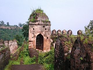
Changbhakar State, also known as Chang Bhakar, was one of the princely states of British Empire in India in the Chhattisgarh States Agency. It included 117 villages and had an area of 2,330 square kilometres (899 sq mi) with a 1941 population of 21,266 people. Bharatpur was the capital of the princely state.

<span class="mw-page-title-main">Umed Singh II</span> Maharaja of Kotah from 1889–1940

Colonel HH Maharajadhiraj Shri Maharaja Mahim Mahendra Maharao Raja Sir Umaid Singh II was the 18th Hada Chauhan ruler of the Princely State of Kotah from the year 1889 to 1940.

<span class="mw-page-title-main">Orchha State</span> Princely state of India

Orchha State was a kingdom situated in the Bundelkhand region and later a princely state in British India. The state was ruled by Bundela clan of Rajputs. It was located within what is now the state of Madhya Pradesh.

<span class="mw-page-title-main">Maratha titles</span> Titles used by Maratha community of India

The following list includes a brief about the titles of nobility or orders of chivalry used by the Marathas of India and by the Marathis/Konkanis in general.

<span class="mw-page-title-main">Raigarh State</span> Indian princely state during the British Raj

Raigarh was a princely state in India at the time of the British Raj. The state was ruled by a Gond dynasty of Gond clan.

<span class="mw-page-title-main">Kharsawan State</span> Princely state of the British Raj

Kharsawan State, also spelt Kharsua or kharaswan, (Odia:ଖରସୁଆଁ)was a princely state in India during the era of the British Raj. The state had a privy purse of 33,000 Rs.It was one of the Odia Princely states of India during the period of the British Raj and the major language spoken in the area is Odia.

<span class="mw-page-title-main">Surguja State</span> Princely state of Central India

Surguja State was one of the main princely states of Central India during the period of the British Raj, even though it was not entitled to any gun salute. Formerly it was placed under the Central India Agency, but in 1905 it was transferred to the Eastern States Agency.

<span class="mw-page-title-main">Jashpur State</span>

Jashpur State was one of the princely states of India during the period of the British Raj. The town of Jashpur was the former state's capital. The rulers were Rajputs of Chauhan Clan.

<span class="mw-page-title-main">Raghogarh State</span>

Raghogarh State, also known as Raghugarh and as Khichiwara, was a princely state of the Gwalior Residency, under the Central India Agency of the British Raj. It was a Thikana state of about 109 km2 with a population of 19,446 inhabitants in 1901. The Parbati River marked the western border of the state. The capital was at Raghogarh in present-day Guna district of Madhya Pradesh.

Raksel is a Rajput clan. They are the descendants of the Haihaiyavanshi. The Raksel Rajputs ruled several states in India during the Middle Ages and British rule, including Surguja State and Udaipur. Jaipur (kuchhwaah) Rajput Raja Man Singh was ruling Palamu prior to the rule of the Chero dynasty.

References

22°28′N83°13′E / 22.47°N 83.22°E / 22.47; 83.22