Union City, Georgia

Last updated

Union City, Georgia
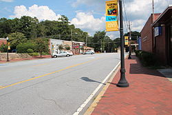
Downtown Union City, Georgia.JPG
Downtown Union City
Flag of Union City, Georgia.png
Seal of Union City, Georgia.png
Logo of Union City, Georgia.png
Fulton County Georgia Incorporated and Unincorporated areas Union City Highlighted.svg
Location in Fulton County and the state of Georgia
USA Georgia location map.svg
Red pog.svg
Union City, Georgia
Location in the United States
Usa edcp location map.svg
Red pog.svg
Union City, Georgia
Union City, Georgia (the United States)
Coordinates: 33°36′18″N84°29′37″W / 33.60500°N 84.49361°W / 33.60500; -84.49361 [1]
Country United States
State Georgia
County Fulton
Government
  MayorVince Williams
Area
[2]
  Total19.83 sq mi (51.37 km2)
  Land19.68 sq mi (50.96 km2)
  Water0.16 sq mi (0.41 km2)
Elevation
[1]
971 ft (296 m)
Population
 (2020)
  Total26,830
  Density1,363.66/sq mi (526.51/km2)
Time zone UTC-5 (Eastern (EST))
  Summer (DST) UTC-4 (EDT)
ZIP code
30291
Area code 770
FIPS code 13-78324 [3]
GNIS feature ID2405627 [1]
Website unioncityga.org
Union City Gateway sign located on Flat Shoals Road Union City, GA Gateway Signage.jpg
Union City Gateway sign located on Flat Shoals Road

Union City is a city in Fulton County, Georgia, United States. The population was 26,830 at the 2020 census. [4]

Contents

History

Union City Hall Union City, GA - City Hall.jpg
Union City Hall

The Georgia General Assembly incorporated Union City in 1908. [5] One source claims that the town was named for the union of rails at a railroad junction, [6] while another version states the name commemorates a "Farmer's Union" which once was headquartered here. [5]

Geography

According to the United States Census Bureau, the city has a total area of 19.3 square miles (50.0 km2), of which 19.1 square miles (49.5 km2) is land and 0.2 square miles (0.5 km2), or 0.83%, is water.

Demographics

Historical population
CensusPop.Note
1910 534
1920 62016.1%
1930 77625.2%
1940 88413.9%
1950 1,49068.6%
1960 2,11842.1%
1970 3,03143.1%
1980 4,78057.7%
1990 8,37575.2%
2000 11,62138.8%
2010 19,45667.4%
2020 26,83037.9%
U.S. Decennial Census [7]
1850-1870 [8] 1880 [9]
1890-1910 [10] 1920-1930 [11]
1930-1940 [12] 1940-1950 [13]
1960-1980 [14] 1980-2000 [15]
Union City racial composition as of 2020 [16]
RaceNum.Perc.
White (non-Hispanic)1,2204.55%
Black or African American (non-Hispanic)22,68684.55%
Native American 510.19%
Asian 1350.5%
Pacific Islander 120.04%
Other/Mixed 7332.73%
Hispanic or Latino 1,9937.43%

As of the 2020 United States census, there were 26,830 people, 8,088 households, and 4,681 families residing in the city.

In 2000, the median household income was $35,322 and the median family income was $39,697. Males had a median income of $30,421 versus $28,111 for females. The per capita income for the city was $17,208. About 9.9% of families and 12.1% of the population were below the poverty line, including 14.0% of those under age 18 and 14.3% of those age 65 or over.
Education

K-12 schools

Union City is in the Fulton County School District. [17]

Elementary schools
Middle schools
High school
Charter schools

Colleges and universities

Related Research Articles

<span class="mw-page-title-main">Whitfield County, Georgia</span> County in Georgia, United States

Whitfield County is a county located in the northwestern part of the U.S. state of Georgia. As of the 2020 census shows a population of 102,864. The county seat is Dalton. The county was created on December 30, 1851, and named after George Whitefield, Methodist evangelist. The "e" was omitted to reflect the pronunciation of his name.

<span class="mw-page-title-main">Towns County, Georgia</span> County in Georgia, United States

Towns County is a county located in the northeastern part of the U.S. state of Georgia. As of the 2020 census, the population was 12,493. Its county seat is Hiawassee. The county was created on March 6, 1856, and named for lawyer, legislator, and politician George W. Towns.

<span class="mw-page-title-main">Paulding County, Georgia</span> County in Georgia, United States

Paulding County is a county located in the northwestern part of the U.S. state of Georgia. Part of Metro Atlanta, it had an estimated population of 168,661 in 2020. The county seat is Dallas.

<span class="mw-page-title-main">Gordon County, Georgia</span> County in Georgia, United States

Gordon County is a county located in the northwestern part of the U.S. state of Georgia. As of the 2020 census, the population was 57,544. The county seat is Calhoun. Gordon County comprises the Calhoun, GA Micropolitan Statistical Area, which is included in the Atlanta–Athens-Clarke County–Sandy Springs, GA-AL CSA.

<span class="mw-page-title-main">Fulton County, Georgia</span> County in Georgia, United States

Fulton County is a county in the north-central portion of the U.S. state of Georgia. As of the 2020 United States census, the population was 1,066,710, making it the state's most populous county. Its county seat and most populous city is Atlanta, the state capital. About 90% of the city of Atlanta is within Fulton County; the remaining portion is in DeKalb County. Fulton County is part of the Atlanta–Sandy Springs–Roswell metropolitan statistical area.

<span class="mw-page-title-main">Catoosa County, Georgia</span> County in Georgia, United States

Catoosa County is a county located in the northwestern part of the U.S. state of Georgia. According to the 2020 census, the population was 67,872. The county seat is Ringgold. The county was created on December 5, 1853. The meaning of the Cherokee language name "Catoosa" is obscure. "Catoosa" may come from the Cherokee words gatusi or gatu'gitse.

<span class="mw-page-title-main">Ben Hill County, Georgia</span> County in Georgia, United States

Ben Hill County is a county located in the U.S. state of Georgia. As of the 2020 census, the population was 17,194. The county seat is Fitzgerald. The county was organized in 1906. It is named after Benjamin Harvey Hill, a former Confederate and United States Senator.

<span class="mw-page-title-main">Barrow County, Georgia</span> County in Georgia, United States

Barrow County is a county located in the north central portion of the U.S. state of Georgia. As of the 2020 census, its population was 83,505. Its county seat is Winder. Barrow County is included in the Atlanta–Sandy Springs–Roswell metropolitan statistical area.

<span class="mw-page-title-main">Gillsville, Georgia</span> City in Georgia, United States

Gillsville is a city in Banks and Hall counties in the U.S. state of Georgia. The population was 235 at the 2010 census.

<span class="mw-page-title-main">Lula, Georgia</span> City in Georgia, United States

Lula is a city in Hall and Banks counties in the U.S. state of Georgia. Most of the city is in Hall County, with a small eastern portion of the city located in Banks County. The population was 2,822 at the 2020 census. The Hall County portion of Lula is part of the Gainesville, GA Metropolitan Statistical Area. Lula is the home of RailRoad Days, a yearly festival held usually every May. Lula is the railroad junction between the Atlanta northeast line and the Athens north line of Norfolk Southern Railway.

<span class="mw-page-title-main">Emerson, Georgia</span> City in Georgia, United States

Emerson is a city in far southern Bartow County, Georgia, United States, on highways US-41/GA-3, GA-293, and I-75. The population was 1,470 at the 2010 census, an increase of 34% over the 2000 count of 1,092.

<span class="mw-page-title-main">Trenton, Georgia</span> City in Georgia, United States

Trenton is a city and the only incorporated municipality in Dade County, Georgia, United States—and as such, it serves as the county seat. The population was 2,195 at the 2020 census. Trenton is part of the Chattanooga, Tennessee–GA Metropolitan Statistical Area.

<span class="mw-page-title-main">Tyrone, Georgia</span> Town in Georgia, United States

Tyrone is a town in Fayette County, Georgia, United States. The population was 7,658 in 2020. The estimated population in 2018 was 7,388. It is a part of the Atlanta metropolitan area.

<span class="mw-page-title-main">East Point, Georgia</span> City in Georgia, United States

East Point is a suburban city located southwest of Atlanta in Fulton County, Georgia, United States. As of the 2020 census, the city had a population of 38,358. The city name is derived from being at the opposite end of the former Atlanta and West Point Railroad from West Point.

<span class="mw-page-title-main">Fairburn, Georgia</span> City in Georgia, United States

Fairburn is a city in Fulton County, Georgia, United States, with a population of 16,483, according to the 2020 census. Though it has a rich history of its own, the city is now a closely linked suburb of Atlanta, which lies just 17 miles to the north.

<span class="mw-page-title-main">Roswell, Georgia</span> City in Georgia, United States

Roswell is a city in northern Fulton County, Georgia, United States. At the official 2020 census, the city had a population of 92,883, making Roswell the state's ninth largest city. A suburb of Atlanta, Roswell has an affluent historic district.

<span class="mw-page-title-main">Clarkesville, Georgia</span> City in Georgia, United States

Clarkesville is a city that is the county seat of Habersham County, Georgia, United States. As of the 2020 census, it had a population of 1,911, up from the 2010 census population of 1,733, up from 1,248 at the 2000 census.

<span class="mw-page-title-main">Buchanan, Georgia</span> City in Georgia, United States

Buchanan is a city and the county seat of Haralson County, Georgia, United States. The population was 1,104 at the 2010 census, up from 941 at the 2000 census.

<span class="mw-page-title-main">Milton, Georgia</span> City in Fulton County, Georgia, United States

Milton is a city in Fulton County, Georgia, United States. Located about 30 mi (48 km) due north of Atlanta, Milton is known for its rural and equestrian heritage. The city was incorporated on December 1, 2006, out of the unincorporated northernmost part of northern Fulton County. As of 2020, its population was 41,296.

<span class="mw-page-title-main">Johns Creek, Georgia</span> City in Georgia, United States

Johns Creek is a city in Fulton County, Georgia, United States. According to the 2020 census, the population was 82,453. The city is a northeastern suburb of Atlanta.

References

  1. 1 2 3 U.S. Geological Survey Geographic Names Information System: Union City, Georgia
  2. "2020 U.S. Gazetteer Files". United States Census Bureau. Retrieved December 18, 2021.
  3. "U.S. Census website". United States Census Bureau . Retrieved January 31, 2008.
  4. "Explore Census Data". data.census.gov. Retrieved November 16, 2023.
  5. 1 2 "Union City". GeorgiaGov. Retrieved June 24, 2019.
  6. Krakow, Kenneth K. (1975). Georgia Place-Names: Their History and Origins (PDF). Macon, GA: Winship Press. p. 237. ISBN   0-915430-00-2.
  7. "Decennial Census of Population and Housing by Decade". United States Census Bureau.
  8. "1870 Census of Population - Georgia" (PDF). United States Census Bureau. 1870.
  9. "1880 Census of Population - Georgia" (PDF). United States Census Bureau. 1880.
  10. "1910 Census of Population - Georgia" (PDF). United States Census Bureau. 1930.
  11. "1930 Census of Population - Georgia" (PDF). United States Census Bureau. 1930. p. 253.
  12. "1940 Census of Population - Georgia" (PDF). United States Census Bureau. 1940.
  13. "1950 Census of Population - Georgia" (PDF). United States Census Bureau. 1980.
  14. "1980 Census of Population - Number of Inhabitants - Georgia" (PDF). United States Census Bureau. 1980.
  15. "2000 Census of Population - General Population Characteristics - Georgia" (PDF). United States Census Bureau. 2000.
  16. "Explore Census Data". data.census.gov. Retrieved December 13, 2021.
  17. "2020 CENSUS - SCHOOL DISTRICT REFERENCE MAP: Fulton County, GA" (PDF). U.S. Census Bureau . Retrieved September 24, 2024.