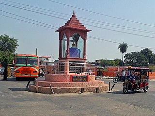
Champawat is a town and a Nagar Palika Parishad in Champawat district in the state of Uttarakhand, India. It is the administrative headquarters of Champawat district. The town was the former capital of the Kumaon Kingdom.

Budaun is a medieval city and headquarters of Budaun district, in the Indian state of Uttar Pradesh. It is located about a mile east of the Sot river, and 27 km north of the Ganges, in the Rohilkhand region of Uttar Pradesh. According to the 2011 census, it has a population of 159,221, which is projected at 161,555 at present. Budaun rose to historical importance as the capital of the Delhi Sultanate for four years from 1210 CE to 1214 CE during the reign of Sultan Iltutmish. It was the most important post of Northern Frontier during Mughal reign. Budaun is a big market, historically famous and religiously important city. Budaun is 230 km south-east of New Delhi and 245 km north-west of Lucknow, both taking about 6 hours by road.
Kurara is a town and a nagar panchayat in Hamirpur district in the Indian state of Uttar Pradesh.
Behta Hajipur is a census town in the Loni block of Ghaziabad district in the Indian state of Uttar Pradesh. It is a part of the National Capital Region (NCR). At one end (southwest), the town's boundary terminates at National Highway 709B, which connects Delhi to Saharanpur, and at the other end (northeast), the boundary ends at Loni-Ghaziabad Road. It also share its territories with the neighboring census town, Mandoli.
Bisauli is a town and a municipal board in Badaun district in the state of Uttar Pradesh, India. It is settled on Badaun - Moradabad Highway. Bisauli is known for its temples and mosques abounding the town. Bisauli is a constituency of District Budaun. Member of Legislative Assembly from Bisuli is Ashutosh Maurya of Samajwadi Party
Dataganj is a town and a nagar palika in Badaun district in the state of Uttar Pradesh, India.
Faizganj is a town and a nagar panchayat in Budaun district in the state of Uttar Pradesh, India.
Gursarai is a city and municipal board in the Jhansi district of the Indian state of Uttar Pradesh. Gursarai is situated in the Garautha Tehsil. An emerging city in Jhansi District With having an old and established market, it's a lifeline for the nearby village people who come and sell their farm produces.
Handia is a town, near the city of Prayagraj and a nagar panchayat in the Prayagraj district of the Indian state of Uttar Pradesh.
Kant is a town and a nagar panchayat of Shahjahanpur district in the Indian state of Uttar Pradesh.
Khudaganj is a town and a nagar panchayat in Tehsil Tilhar Shahjahanpur district in the Indian state of Uttar Pradesh.
Maholi is a town and a nagar panchayat in Sitapur district in the Indian state of Uttar Pradesh. It is now one of the 7 Tehsils in District Sitapur being carved out in 2013 from Misrikh.
Obra is a town, Tehsil, and Assembly constituency of the Indian state of Uttar Pradesh. It is located in the Sonebhadra district. It has been upgraded from the stature of Nagar Panchayat, and was previously a part of the Mirzapur District. Obra is located 137 km from Varanasi at the Banks of Renu & Sone River with population of 46,574 as per the 2011 India Census. State-owned UPRVUNL and UPJVUNL have a coal-fired thermal power plant and a hydroelectric power plant in Obra, respectively. The thermal and hydroelectric power industries are the major source of employment, either directly or indirectly. Obra is not very well connected by rail. The nearest railway station is Chopan, which is about 10 kilometers from Obra, and has connectivity to other major cities of India. Recreational places in Obra include Jawahar Bal Udayan, Ambedkar Stadium, Lord Shiva's temple, Sone river banks, and Parsoi and Kharatiya villages. Restructuring of government residential colony is ongoing as new power plants are being constructed.
Pukhrayan is a town and a Municipality in Amrodha Block in Kanpur Dehat district in the Indian state of Uttar Pradesh. Found to the south-west of Mati on National Highway 25, Pukhrayan is 2 km (1.2 mi) from Bhognipur.
Sakit is a town and a Nagar panchayat in the Etah district of the Indian state of Uttar Pradesh.
Saurikh is a nagar panchayat in Kannauj district in the Indian state of Uttar Pradesh. Its old name was Sau-Rishi.It is located near main industrial and educational hub of Dibiyapur which is around at a distance of 55 km from the town.
Tirwa is a town in Kannauj district in the Indian state of Uttar Pradesh.

Ujhani is an industry-based city and a municipal board in Badaun district in the Indian state of Uttar Pradesh.

Mahmudabad, also known as Mahmudabad Awadh is a town and a municipal board in Sitapur district in the Indian state of Uttar Pradesh.
Said Nagli is a town in Amroha district in the Indian state of Uttar Pradesh. It is situated on State Highway 51, around 15 km from Hasanpur and 19 km from Sambhal. Said Nagli has its own post office with PIN code 244242 and a police station.


