Valley Junction, Wisconsin | |
|---|---|
 | |
 Valley Junction, Wisconsin  Valley Junction, Wisconsin | |
| Coordinates: 44°03′12″N90°24′44″W / 44.05333°N 90.41222°W | |
| Country | |
| State | |
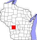
| County | Monroe |
| Elevation | 925 ft (282 m) |
| Time zone | UTC-6 (Central (CST)) |
| • Summer (DST) | UTC-5 (CDT) |
| Area code | 608 |
| GNIS feature ID | 1576019 [1] |
Valley Junction is an unincorporated community located in the Town of Byron in Monroe County, Wisconsin, United States. [1] It is located at the intersection of Wisconsin Highway 173, Monroe County Trunk Highway G, and Monroe County Highway N. [2]
Contents