
Gordonville is a town in Lowndes County, Alabama, United States. At the 2010 census the population was 326, up from 318 in 2000. It is part of the Montgomery Metropolitan Statistical Area. It incorporated effective January 20, 1990.
Glenwood is a town in Union Township, Rush County and in Orange and Fairview townships, Fayette County in the U.S. state of Indiana. The population was 250 at the 2010 census.

Cambridge is a city in Story County, Iowa, United States. The population was 827 at the 2020 census. It is part of the Ames, Iowa Metropolitan Statistical Area, which is a part of the larger Ames-Boone, Iowa Combined Statistical Area.

Villa Hills is a home rule-class city in Kenton County, Kentucky along the Ohio River. The population was 7,310 at the 2020 census.
Blackberry Township is a township in Itasca County, Minnesota, United States. The population was 827 at the 2020 census.
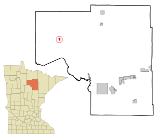
Squaw Lake is a city in Itasca County, Minnesota, United States. The population was 98 at the 2020 census.

Crompond is a hamlet and census-designated place (CDP) located in the town of Yorktown in Westchester County, New York, United States. The population was 2,292 at the 2010 census.

Minnewaukan is a city in Benson County, North Dakota, United States. It serves as the county seat and is fourth largest city in the county, after Fort Totten, Leeds, and Maddock. The population was 199 at the 2020 census. Minnewaukan was founded in 1884.

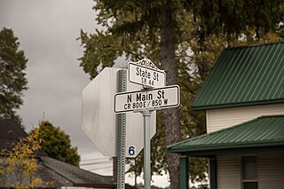
Thompson is a city in Grand Forks County, North Dakota, United States. It is part of the "Grand Forks, ND-MN Metropolitan Statistical Area" or "Greater Grand Forks". It is located on the border of Allendale and Walle townships, with Walle on the east and Allendale on the west. The population was 1,101 at the 2020 census. Thompson was founded in 1881.

Arcadia is a village in Hancock County, Ohio, United States. The population was 564 at the 2020 census.

Whitesville is a town and former coal town in Boone County, West Virginia, United States, along the Big Coal River. The population was 361 at the 2020 census. Whitesville was incorporated on August 15, 1935, by the Boone County Circuit Court. The town derives its name from B. W. White, a pioneer settler. Whitesville was formerly known as Jarrold's Valley and Pritchard City.

Elk Garden is a town in Mineral County, West Virginia, United States. It is part of the 'Cumberland, MD-WV Metropolitan Statistical Area'. The population was 211 at the 2020 census. Elk Garden High School was consolidated into Keyser High School in 1997. However the Primary School is still in session, offering classes from Pre-Kindergarten through the fifth grade. The school mascot is the Elk Garden Stags. Elk Garden was incorporated in 1890 by the Mineral County Circuit Court. It is named for an elk lick near the original town site.

Oakland is a town in Burnett County in the U.S. state of Wisconsin. The population was 827 at the 2010 census. It is along Wisconsin Highway 35. The unincorporated communities of Oakland and Yellow Lake are located in the town.

Lake is a town in Marinette County, Wisconsin, United States. As of the 2000 census, the town population was 1,064. The unincorporated community of Loomis is located in the town,

Lafayette is a town in Monroe County, Wisconsin, United States. The population was 318 at the 2000 census.

Buena Vista is a town in Portage County, Wisconsin, United States. The population was 1,198 at the 2010 census. The unincorporated communities of Coddington and Keene are located within the town.
Colfax is a town in Dunn County, Wisconsin, United States. The population was 909 at the 2000 census.
Wonewoc is a town in Juneau County, Wisconsin, United States. The population was 783 at the 2000 census. The Village of Wonewoc and the village of Union Center are located within the town.

Montello is a town in Marquette County, Wisconsin, United States. The population was 1,043 at the 2000 census. The City of Montello and the unincorporated community of Glen Oak are located within the town.
Hammond is a town in St. Croix County, Wisconsin, United States. The population was 947 at the 2000 census. The Village of Hammond is located within the town.

