
Smyrna is a town in Aroostook County, Maine, United States. The population was 439 at the 2020 census.

Pentwater is a village in Oceana County in the U.S. state of Michigan. The population was 890 at the 2020 census. The village is located within Pentwater Township. Pentwater is home to Mears State Park. The name Pentwater comes from Pent or Penned up waters. The entrance to the channel is notoriously shallow and for many years dictated the size of vessels that the village was able to accommodate.

Centreville is a village in the U.S. state of Michigan and the county seat of St. Joseph County. The population was 1,425 at the 2010 census.

Middlefield is a village in Geauga County, Ohio, United States. The population was 2,748 at the 2020 census. It is part of the Cleveland metropolitan area. Middlefield is known for being the center of the world's fourth largest Amish settlement, and its significant manufacturing base, which includes Gold Key Processing, Inc., Duncan Toys and KraftMaid. Because of its central location, home of the areas' public schools and prominent business and retail presence, Middlefield village is considered the hub community for Huntsburg, Parkman, and Middlefield Townships.

Sugarcreek is a village in Tuscarawas County, Ohio, United States. The population was 2,373 at the 2020 census. It is known as "The Little Switzerland of Ohio." Located in Ohio's Amish Country, the village is part of a large regional tourism industry. In the center of town stands one of the world's largest cuckoo clocks, which was previously featured on the cover of the Guinness World Records book in 1977.
Friendship is a village in Adams County in the U.S. state of Wisconsin. It is the county seat of Adams County. The population was 725 at the 2010 census.

Sherwood is a village in Calumet County, Wisconsin, United States. The population was 2,713 at the 2010 census. The former historical unincorporated community of High Cliff is located within present-day Sherwood.
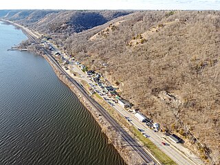
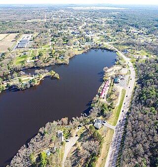
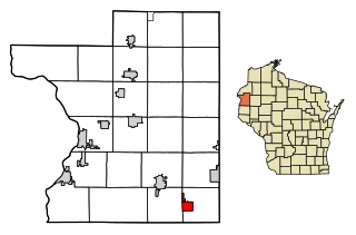
Ferryville is a village in Crawford County, Wisconsin, United States. The population was 176 at the 2010 census. It is located on Wisconsin Highway 35 along the Great River Road.

Monticello is a village in Green County, Wisconsin, United States. The population was 1,217 as of the 2010 census.

Cleveland is a village in Manitowoc County, Wisconsin, United States. The population was 1,579 at the 2020 census.

Pigeon Falls is a village in Trempealeau County, Wisconsin, United States. The population was 411 at the 2010 census.

Belleville is a village in Dane and Green counties in the U.S. state of Wisconsin. The population was 2,491 at the 2020 census. Of this, 1,909 were in Dane County, and 582 were in Green County.

Viola is a village in Richland (mostly) and Vernon counties in the U.S. state of Wisconsin. The population was 699 at the 2010 census. Of this, 477 were in Richland County, and 222 were in Vernon County.

Unity is a village in Clark and Marathon counties in the U.S. state of Wisconsin. It is part of the Wausau, Wisconsin Metropolitan Statistical Area. The population was 343 at the 2010 census. Of this, 204 were in Marathon County, and 139 were in Clark County. The village is located in northeastern town of Unity in Clark County and northwestern town of Brighton in Marathon County.

Lowell is a village in Dodge County, Wisconsin, United States, along the Beaver Dam River. The population was 340 at the 2010 census. The village is located within the Town of Lowell.

Hixton is a village in Jackson County, Wisconsin, United States, along the Trempealeau River. The population was 433 at the 2010 census. The village is located within the Town of Hixton.

Melrose is a village in Jackson County, Wisconsin, United States. The population was 503 at the 2010 census. The village is located within the Town of Melrose.
Clear Lake is a village in Polk County, Wisconsin, United States. The population was 1,099 at the 2020 census. The village is adjacent to the Town of Clear Lake along U.S. Highway 63.

Plainfield is a village in Waushara County, Wisconsin, United States. The village is located almost entirely within the Town of Plainfield. A tiny portion extends into adjacent Town of Oasis. The population was 897 at the 2010 census.
Pittsfield is a census-designated place (CDP) in the town of Pittsfield in Somerset County, Maine, United States. The population was 3,217 at the 2000 census.


