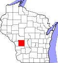
New Lyme, Wisconsin

Last updated

New Lyme, Wisconsin
WIMap-doton-New Lyme.png
Location of New Lyme, Wisconsin
Coordinates: 44°8′35″N90°42′23″W / 44.14306°N 90.70639°W / 44.14306; -90.70639
Country Flag of the United States.svg  United States
State Flag of Wisconsin.svg  Wisconsin
County Monroe
Area
  Total36.1 sq mi (93.4 km2)
  Land35.6 sq mi (92.1 km2)
  Water0.5 sq mi (1.3 km2)
Elevation
[1]
1,119 ft (341 m)
Population
 (2000)
  Total141
  Density4.0/sq mi (1.5/km2)
Time zone UTC-6 (Central (CST))
  Summer (DST) UTC-5 (CDT)
Area code 608
FIPS code 55-56950 [2]
GNIS feature ID1583814 [1]

New Lyme is a town in Monroe County, Wisconsin, United States. The population was 141 at the 2000 census.

Contents

Geography

According to the United States Census Bureau, the town has a total area of 36.1 square miles (93.4 km2), of which, 35.6 square miles (92.1 km2) of it is land and 0.5 square miles (1.3 km2) of it (1.36%) is water.

Demographics

As of the census [2] of 2000, there were 141 people, 57 households, and 42 families residing in the town. The population density was 4.0 people per square mile (1.5/km2). There were 80 housing units at an average density of 2.2 per square mile (0.9/km2). The racial makeup of the town was 100.00% White.

There were 57 households, out of which 24.6% had children under the age of 18 living with them, 68.4% were married couples living together, 1.8% had a female householder with no husband present, and 26.3% were non-families. 17.5% of all households were made up of individuals, and 3.5% had someone living alone who was 65 years of age or older. The average household size was 2.47 and the average family size was 2.74.

In the town, the population was spread out, with 21.3% under the age of 18, 5.7% from 18 to 24, 32.6% from 25 to 44, 24.1% from 45 to 64, and 16.3% who were 65 years of age or older. The median age was 40 years. For every 100 females, there were 120.3 males. For every 100 females age 18 and over, there were 113.5 males.

The median income for a household in the town was $39,167, and the median income for a family was $39,792. Males had a median income of $20,000 versus $20,208 for females. The per capita income for the town was $20,306. There were 9.4% of families and 13.5% of the population living below the poverty line, including 25.9% of under eighteens and none of those over 64.

Related Research Articles

<span class="mw-page-title-main">McCordsville, Indiana</span> Town in Indiana, United States

McCordsville is a town in Vernon Township, Hancock County, Indiana, United States. The town is a fast-growing suburb of Indianapolis with an estimated population of 8,592 in 2020.

<span class="mw-page-title-main">Mooreland, Indiana</span> Town in Indiana, United States

Mooreland is a town in Blue River Township, Henry County, Indiana, United States. The population was 375 at the 2010 census.

<span class="mw-page-title-main">Markleville, Indiana</span> Town in Indiana, United States

Markleville is a town in Adams Township, Madison County, Indiana, United States. It is part of the Indianapolis–Carmel–Anderson metropolitan statistical area. The population was 484 at the 2020 census.

<span class="mw-page-title-main">Grand Isle, Maine</span> Town in the state of Maine, United States

Grand Isle is a town in Aroostook County, Maine, United States. The population was 366 at the 2020 census. The village of Grand Isle is in the northwestern part of the town.

<span class="mw-page-title-main">Merrill, Maine</span> Town in the state of Maine, United States

Merrill is a town in Aroostook County, Maine, United States. The population was 208 at the 2020 census.

<span class="mw-page-title-main">Sorrento, Maine</span> Town in Maine, United States

Sorrento is a town in Hancock County, Maine, United States. The population was 279 at the 2020 census.

<span class="mw-page-title-main">West Gardiner, Maine</span> Town in the state of Maine, United States

West Gardiner is a town in Kennebec County, Maine, United States. The population was 3,671 at the 2020 census. West Gardiner is included in the Augusta, Maine micropolitan New England City and Town Area.

Ripley is a town in Somerset County, Maine, United States. The community was named after Brigadier General Eleazer Wheelock Ripley of the War of 1812. The population was 484 at the 2020 census.

<span class="mw-page-title-main">Monroe, Maine</span> Town in the state of Maine, United States

Monroe is a town in Waldo County, Maine, United States named for President James Monroe. The population was 931 at the 2020 census.

Beddington is a town in Washington County, Maine, United States. The population was 60 at the 2020 census. It is the third-smallest organized town in Maine after Frye Island and Frenchboro.

<span class="mw-page-title-main">St. Rosa, Minnesota</span> City in Minnesota, United States

Saint Rosa is a city in Stearns County, Minnesota, United States. The population was 58 at the 2020 census. It is part of the St. Cloud Metropolitan Statistical Area.

<span class="mw-page-title-main">Vanlue, Ohio</span> Village in Ohio, United States

Vanlue is a village in Hancock County, Ohio, United States. The population was 341 at the 2020 census.

<span class="mw-page-title-main">Bayard, West Virginia</span> Town in West Virginia, United States

Bayard is a town in Grant County, West Virginia, United States. The population was 200 at the 2020 census. Bayard was incorporated in 1893 and named in honor of Thomas F. Bayard, Jr., who later became a United States senator from Delaware (1923–1929). Bayard was founded on the West Virginia Central and Pittsburgh Railroad as a coal mining community. Coal mining has remained the town's chief industry.

<span class="mw-page-title-main">Worthington, West Virginia</span> Town in West Virginia, United States

Worthington is a town in Marion County, West Virginia, United States. The population was 158 at the 2010 census. Worthington was incorporated in 1893 and named for Colonel George Worthington, an early settler. U.S. Route 19 passes through the town.

<span class="mw-page-title-main">Montrose, West Virginia</span> Town in West Virginia, United States

Montrose is a town in Randolph County, West Virginia, United States. The population was 141 at the 2020 census.

<span class="mw-page-title-main">Peeksville, Wisconsin</span> Town in Wisconsin, United States

Peeksville is a town in Ashland County in the U.S. state of Wisconsin. The population was 141 at the 2010 census.

<span class="mw-page-title-main">Marietta, Wisconsin</span> Town in Wisconsin, United States

Marietta is a town in Crawford County, Wisconsin, United States. The population was 510 at the 2000 census. The unincorporated community of Easter Rock is located in the town. The unincorporated community of Boydtown is located partially in the town.

<span class="mw-page-title-main">Kingston, Juneau County, Wisconsin</span> Town in Wisconsin, United States

Kingston is a town in Juneau County, Wisconsin, United States. Its population was 58 at the 2000 census. The unincorporated communities of Mather and Meadow Valley are located in the town.

<span class="mw-page-title-main">Skanawan, Wisconsin</span> Town in Wisconsin, United States

Skanawan is a town in Lincoln County, Wisconsin, United States. The population was 391 at the 2010 census, up from 354 at the 2000 census.

<span class="mw-page-title-main">Monico, Wisconsin</span> Town in Wisconsin, United States

Monico is a town in Oneida County, Wisconsin, United States. The population was 260 at the 2020 census. The unincorporated community of Monico is located in the town.

References

  1. 1 2 "US Board on Geographic Names". United States Geological Survey. October 25, 2007. Retrieved January 31, 2008.
  2. 1 2 "U.S. Census website". United States Census Bureau . Retrieved January 31, 2008.