Kendall, Wisconsin | |
---|---|
Coordinates: 43°47′38″N90°22′09″W / 43.79389°N 90.36917°W | |
Country | United States |
State | Wisconsin |
County | Monroe |
Area | |
• Total | 0.76 sq mi (1.98 km2) |
• Land | 0.76 sq mi (1.98 km2) |
• Water | 0.00 sq mi (0.00 km2) |
Elevation | 1,030 ft (314 m) |
Population | |
• Total | 472 |
• Estimate (2019) [4] | 472 |
• Density | 617.80/sq mi (238.41/km2) |
Time zone | UTC-6 (Central (CST)) |
• Summer (DST) | UTC-5 (CDT) |
Area code | 608 |
FIPS code | 55-39150 [5] |
GNIS feature ID | 1567404 [2] |
Website | www |
Kendall is a village in Monroe County, Wisconsin, United States, along the Baraboo River. The population was 472 at the 2010 census.
A post office called Kendall has been in operation since 1874. [6] The village was named for L. G. Kendall, a local farmer and landowner. [7]
Kendall is located at 43°47′38″N90°22′09″W / 43.793890°N 90.369226°W (43.793890, -90.369226). [8]
According to the United States Census Bureau, the village has a total area of 0.74 square miles (1.92 km2), all of it land. [9]
Census | Pop. | Note | %± |
---|---|---|---|
1880 | 282 | — | |
1890 | 304 | 7.8% | |
1900 | 460 | 51.3% | |
1910 | 477 | 3.7% | |
1920 | 506 | 6.1% | |
1930 | 517 | 2.2% | |
1940 | 478 | −7.5% | |
1950 | 558 | 16.7% | |
1960 | 528 | −5.4% | |
1970 | 468 | −11.4% | |
1980 | 486 | 3.8% | |
1990 | 453 | −6.8% | |
2000 | 469 | 3.5% | |
2010 | 472 | 0.6% | |
2019 (est.) | 472 | [4] | 0.0% |
U.S. Decennial Census [10] |
As of the census [3] of 2010, there were 472 people, 198 households, and 133 families living in the village. The population density was 637.8 inhabitants per square mile (246.3/km2). There were 233 housing units at an average density of 314.9 per square mile (121.6/km2). The racial makeup of the village was 97.7% White, 1.3% Native American, 0.2% Asian, and 0.8% from two or more races. Hispanic or Latino of any race were 2.1% of the population.
There were 198 households, of which 29.8% had children under the age of 18 living with them, 50.5% were married couples living together, 12.1% had a female householder with no husband present, 4.5% had a male householder with no wife present, and 32.8% were non-families. 28.3% of all households were made up of individuals, and 11.6% had someone living alone who was 65 years of age or older. The average household size was 2.38 and the average family size was 2.87.
The median age in the village was 42.5 years. 23.3% of residents were under the age of 18; 8.6% were between the ages of 18 and 24; 22.4% were from 25 to 44; 30.4% were from 45 to 64; and 15.7% were 65 years of age or older. The gender makeup of the village was 48.7% male and 51.3% female.
As of the census [5] of 2000, there were 469 people, 200 households, and 126 families living in the village. The population density was 632.2 people per square mile (244.7/km2). There were 213 housing units at an average density of 287.1/sq mi (111.1/km2). The racial makeup of the village was 99.79% White and 0.21% Pacific Islander. Hispanic or Latino of any race were 0.64% of the population.
There were 200 households, out of which 31.0% had children under the age of 18 living with them, 53.0% were married couples living together, 5.5% had a female householder with no husband present, and 37.0% were non-families. 33.0% of all households were made up of individuals, and 17.5% had someone living alone who was 65 years of age or older. The average household size was 2.33 and the average family size was 2.98.
In the village, the population was spread out, with 24.3% under the age of 18, 9.0% from 18 to 24, 27.3% from 25 to 44, 21.1% from 45 to 64, and 18.3% who were 65 years of age or older. The median age was 39 years. For every 100 females, there were 95.4 males. For every 100 females age 18 and over, there were 99.4 males.
The median income for a household in the village was $36,250, and the median income for a family was $43,393. Males had a median income of $30,000 versus $20,938 for females. The per capita income for the village was $21,073. About 8.5% of families and 11.6% of the population were below the poverty line, including 13.5% of those under age 18 and 16.9% of those age 65 or over.
Kendall formerly had intercity passenger rail service available at the Kendalls Depot. Today, the depot is listed on the National Register of Historic Places and the rail line is the Elroy-Sparta State Trail.
Vandiver is a village in Audrain County, Missouri, United States. As of the 2010 census, the village population was 77.
Herman is a village in Washington County, Nebraska, United States. The population was 268 at the 2010 census.
Washington is a village in Washington County, Nebraska, United States. The population was 150 at the 2010 census.
Uplands Park is a village in St. Louis County, Missouri, United States. The population was 445 at the 2010 census. The village is one of many small majority black communities located in the Natural Bridge corridor of mid-St. Louis County, characterized by small homes on small lots.
Nellie is a village in Coshocton County, Ohio, United States, along the Walhonding River. The population was 122 at the 2020 census.
Cuyahoga Heights is a village in Cuyahoga County, Ohio, United States. The population was 573 at the 2020 census. A suburb of Cleveland, it is a part of the Cleveland metropolitan area.
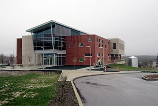
Highland Hills is a village in Cuyahoga County, Ohio, United States. The population was 662 at the 2020 census. A suburb of Cleveland, it was formally incorporated in 1990.
Riverlea is a village in Franklin County, Ohio, United States, surrounded by Worthington on its north, south, and east sides, and bordered on the west by the Olentangy River, across which is Columbus. Riverlea was incorporated in 1939, a small community that formed on former farmland. The population was 599 at the 2020 census.
Hartford is a village in the township of the same name in Licking County, Ohio, United States. The population was 404 at the 2020 census.
Hartville is a village in northern Stark County, Ohio, United States. The population was 3,329 at the 2020 census. It is part of the Canton–Massillon metropolitan area. Hartville lies halfway between Akron and Canton at the intersection of State Routes 43 and 619.
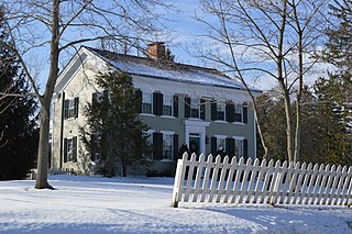
Boston Heights is a village in northern Summit County, Ohio, United States. The population was 1,402 at the 2020 census. It is part of the Akron metropolitan area. Boston Heights is home to the headquarters of Arhaus, a major home furnishings retailer.
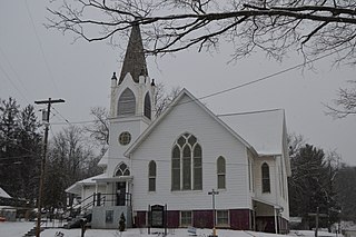
Macksburg is a village in Washington County, Ohio, United States, along the West Fork of Duck Creek. The population was 120 at the 2020 census. The village is about 28 miles (45 km) south of Cambridge, Ohio.
Bradner is a village in Wood County, Ohio, United States. The population was 971 at the 2020 census.
Windsor Heights is a village in Brooke County, West Virginia, United States. It is part of the Wheeling, West Virginia Metropolitan Statistical Area. The population was 423 at the 2010 census. Grace Davis was the mayor as of June 2017.
Fairwater is a village in Fond du Lac County, Wisconsin, United States. The population was 371 at the 2010 census. The town of Metomen surrounds the village.
Avoca is a village in Iowa County, Wisconsin, United States. The population was 637 at the 2010 census. It is part of the Madison Metropolitan Statistical Area. It is named after Avoca in Ireland.
Yuba is a village in Richland County, Wisconsin, United States. The population was 74 at the 2010 census. Yuba is 11 miles southwest of Hillsboro and 17 miles north of Richland Center. County Hwy C runs through the village.
Pigeon Falls is a village in Trempealeau County, Wisconsin, United States. The population was 411 at the 2010 census.
Eastman is a village in Crawford County, Wisconsin, United States. The population was 428 at the 2010 census. The village is located within the Town of Eastman.
Patch Grove is a village in Grant County, Wisconsin, United States. The population was 198 at the 2010 census. The village is located within the Town of Patch Grove.