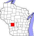
Jefferson, Monroe County, Wisconsin

Last updated

Jefferson, Wisconsin
WIMap-doton-Jefferson c.png
Location of Jefferson, Monroe County, Wisconsin
Coordinates: 43°46′22″N90°45′0″W / 43.77278°N 90.75000°W / 43.77278; -90.75000
Country Flag of the United States.svg  United States
State Flag of Wisconsin.svg  Wisconsin
County Monroe
Area
  Total34.9 sq mi (90.3 km2)
  Land34.9 sq mi (90.3 km2)
  Water0.0 sq mi (0.0 km2)
Elevation
[1]
1,385 ft (422 m)
Population
 (2000)
  Total800
  Density23.0/sq mi (8.9/km2)
Time zone UTC-6 (Central (CST))
  Summer (DST) UTC-5 (CDT)
Area code 608
FIPS code 55-37950 [2]
GNIS feature ID1583453 [1]
Aerial photograph of St. Mary's Church in Jefferson, 1957, with strip farming visible in the background. Strip farming in Wisconsin, USA, 1957.jpg
Aerial photograph of St. Mary's Church in Jefferson, 1957, with strip farming visible in the background.
There are a few other places named Jefferson in Wisconsin.

Jefferson is a town in Monroe County, Wisconsin, United States. The population was 800 at the 2000 census. The unincorporated community of St. Mary's is located within the town.

Contents

Geography

According to the United States Census Bureau, the town has a total area of 34.9 square miles (90.3 km2), all of it land.

Demographics

As of the census [2] of 2000, there were 800 people, 227 households, and 187 families residing in the town. The population density was 23.0 people per square mile (8.9/km2). There were 236 housing units at an average density of 6.8 per square mile (2.6/km2). The racial makeup of the town was 96.62% White, 2.75% Asian, 0.12% from other races, and 0.50% from two or more races. Hispanic or Latino of any race were 1.00% of the population.

There were 227 households, out of which 48.5% had children under the age of 18 living with them, 74.4% were married couples living together, 3.5% had a female householder with no husband present, and 17.2% were non-families. 15.0% of all households were made up of individuals, and 6.6% had someone living alone who was 65 years of age or older. The average household size was 3.52 and the average family size was 3.94.

In the town, the population was spread out, with 40.5% under the age of 18, 7.6% from 18 to 24, 25.8% from 25 to 44, 17.1% from 45 to 64, and 9.0% who were 65 years of age or older. The median age was 27 years. For every 100 females, there were 111.1 males. For every 100 females age 18 and over, there were 108.8 males.

The median income for a household in the town was $33,750, and the median income for a family was $38,036. Males had a median income of $25,375 versus $18,625 for females. The per capita income for the town was $12,511. About 19.2% of families and 26.9% of the population were below the poverty line, including 37.5% of those under age 18 and 20.6% of those age 65 or over.

Related Research Articles

<span class="mw-page-title-main">Harbine, Nebraska</span> Village in Nebraska, United States

Harbine is a village in Jefferson County, Nebraska, United States. The population was 54 at the 2020 census.

<span class="mw-page-title-main">Port Jefferson, Ohio</span> Village in Ohio, United States

Port Jefferson is a village in Salem Township, Shelby County, Ohio, United States. The population was 371 at the 2010 census.

<span class="mw-page-title-main">Washington Township, Jefferson County, Pennsylvania</span> Township in Pennsylvania, United States

Washington Township is a township in Jefferson County, Pennsylvania, United States. The population was 1,890 at the 2020 census. It was named for President George Washington.

<span class="mw-page-title-main">Jefferson, West Virginia</span> Census-designated place in West Virginia, United States

Jefferson is a census-designated place (CDP) in Kanawha County, West Virginia, United States, along the Kanawha River. The population was 676 at the 2010 census. Jefferson was incorporated on March 22, 1997, but was disincorporated less than a decade later on February 21, 2007.

<span class="mw-page-title-main">Matoaka, West Virginia</span> Census-designated place in West Virginia, United States

Matoaka is a census-designated place in Mercer County, West Virginia, United States. The population was 227 at the 2010 census. It is part of the Bluefield, WV-VA micropolitan area which has a population of 107,578. This town is named for Chief Powhatan's daughter Matoaka who was better known by her nickname "Pocahontas". Matoaka became an unincorporated town when it voted to dissolve its charter in May 2018.

<span class="mw-page-title-main">Harman, West Virginia</span> Town in West Virginia, United States

Harman is a town in Randolph County, West Virginia, United States. The population was 96 at the 2020 census.

<span class="mw-page-title-main">Milton, Buffalo County, Wisconsin</span> Town in Wisconsin, United States

Milton is a town in Buffalo County in the U.S. state of Wisconsin. The population was 534 at the 2010 census. The unincorporated community of Czechville is located in the town.

<span class="mw-page-title-main">Jefferson, Green County, Wisconsin</span> Town in Wisconsin, United States

Jefferson is a town in Green County, Wisconsin, United States. The population was 1,212 at the 2000 census. The census-designated place of Juda is located in the town. The unincorporated community of Twin Grove is also located in the town.

<span class="mw-page-title-main">Aztalan, Wisconsin</span> Town in Wisconsin, United States

Aztalan is a town in Jefferson County, Wisconsin, United States. The population was 1,457 at the 2010 census. The unincorporated communities of Aztalan and Jefferson Junction are located in the town.

<span class="mw-page-title-main">Concord, Wisconsin</span> Town in Wisconsin, United States

Concord is a town in Jefferson County, Wisconsin, United States. The population was 2,072 at the 2010 census.

<span class="mw-page-title-main">Farmington, Jefferson County, Wisconsin</span> Town in Wisconsin, United States

Farmington is a town in Jefferson County, Wisconsin, United States. The population as of the 2010 census was 1,380.

<span class="mw-page-title-main">Milford, Wisconsin</span> Town in Wisconsin, United States

Milford is a town in Jefferson County, Wisconsin, United States. The population was 1,099 at the 2010 census. The unincorporated communities of Grellton, Hoopers Mill, Hubbleton, and Milford are located in the town.

<span class="mw-page-title-main">Norrie, Wisconsin</span> Town in Wisconsin, United States

The Town of Norrie is located in Marathon County, Wisconsin, United States. It is part of the Wausau, Wisconsin Metropolitan Statistical Area. The population was 976 at the 2010 census.

<span class="mw-page-title-main">Cylon, Wisconsin</span> Town in Wisconsin, United States

Cylon is a town in St. Croix County, Wisconsin, United States. The population was recorded to be 629 as of the 2000 census.

<span class="mw-page-title-main">Erin Prairie, Wisconsin</span> Town in Wisconsin, United States

Erin Prairie is a town in St. Croix County, Wisconsin, United States. The population was 658 at the 2000 census. The unincorporated communities of Erin Corner and Jewitt are located in the town.

<span class="mw-page-title-main">Jefferson, Vernon County, Wisconsin</span> Town in Wisconsin, United States

Jefferson is a town in Vernon County, Wisconsin, United States. The population was 974 at the 2000 census. The unincorporated communities of Bud, Esofea, and Springville are located with the town.

Watertown is a town in Jefferson County, Wisconsin, United States. The population was 1,975 at the 2010 census. The unincorporated community of Ebenezer is located in the town.

Ashland is a town in Ashland County, Wisconsin. The population was 594 at the time of the 2010 census. The city of Ashland, population 7,908, is located about 15 miles (24 km) northwest of the town. The unincorporated communities of High Bridge, Minersville, North York, and part of Jolmaville are located in the town.

Jefferson is a town in Jefferson County, Wisconsin, United States. The population was 2,178 at the 2010 census. The city of Jefferson is located partially within the town. The census-designated place of Helenville is also located in the town.

Waterloo is a town in Jefferson County in the U.S. state of Wisconsin. The population was 909 at the 2010 census. The city of Waterloo is located within the town. The unincorporated community of Portland is also located partially in the town.

References

  1. 1 2 "US Board on Geographic Names". United States Geological Survey. October 25, 2007. Retrieved January 31, 2008.
  2. 1 2 "U.S. Census website". United States Census Bureau . Retrieved January 31, 2008.