Hyde Park is a neighborhood and historic district in Austin, Texas. Located in Central Austin, Hyde Park is defined by W. 38th Street to the south, W. 51st Street to the north, Duval Street to the east, and Guadalupe Street to the west. It is situated just north of the University of Texas and borders the neighborhoods of Hancock and North Loop.

There are nine historic districts in Meridian, Mississippi. Each of these districts is listed on the National Register of Historic Places. One district, Meridian Downtown Historic District, is a combination of two older districts, Meridian Urban Center Historic District and Union Station Historic District. Many architectural styles are present in the districts, most from the late 19th century and early 20th century, including Queen Anne, Colonial Revival, Italianate, Art Deco, Late Victorian, and Bungalow.

College Square Historic District is a nationally recognized historic district located on a bluff north of downtown Davenport, Iowa, United States. It was listed on the National Register of Historic Places in 1983. The district derives it name from two different colleges that were located here in the 19th century.

The Chautauqua Park Historic District is located on the north side of Des Moines, Iowa, United States. It has been listed on the National Register of Historic Places since 1990. It is part of the Suburban Development in Des Moines Between the World Wars, 1918--1941 MPS.

The Highland Park Historic Business District at Euclid and Sixth Avenues is located in the north-central section of Des Moines, Iowa, United States. It is located on the border of the Oak Park and Highland Park neighborhoods. The commercial historic district has been listed on the National Register of Historic Places since 1998. The Highland Park neighborhood also includes the College Corner Commercial Historic Business District.

The Ingersoll Place Plat Historic District is located in Des Moines, Iowa, United States. It has been listed on the National Register of Historic Places since 2000. The historic significance of the district is based on the concentration of bungalows and square houses as well as a mix of subtypes.

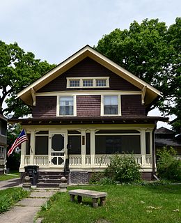
The Kingman Place Historic District is located in Des Moines, Iowa, United States. The historic district contains a well-preserved collection of American Foursquare houses that were built starting in 1902 and continued until 1915. It has been listed on the National Register of Historic Places since 2000. It was part of The Bungalow and Square House--Des Moines Residential Growth and Development MPS.

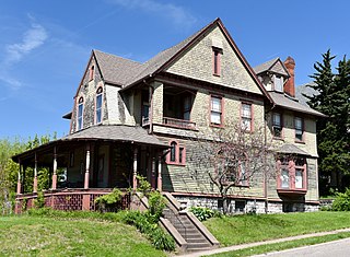
The Oaklands Historic District is located in Des Moines, Iowa, United States. It was a late 19th-century residential area for upper and upper middle class residents of what was then a suburb of North Des Moines. It was also the first naturalistic suburban subdivision in the Des Moines area. The district has been listed on the National Register of Historic Places since 1996. It is part of the Towards a Greater Des Moines MPS.

The Owl's Head Historic District is a residential area located on the west side of Des Moines, Iowa, United States. Among its 50 buildings is the former Iowa governor's mansion. The district has been listed on the National Register of Historic Places since 1978.

The Prospect Park Second Plat Historic District is a nationally recognized historic district located in the north-central section of Des Moines, Iowa, United States. The residential area contained middle to upper class housing that was developed in the late 19th and early 20th centuries in the suburb of North Des Moines. It has been listed on the National Register of Historic Places since 1998. It is part of the Towards a Greater Des Moines MPS.

The Sixth and Forest Historic District is located in Des Moines, Iowa, United States. It is a Victorian era suburban commercial district on the northeastern and northwestern corners of the junction of 6th and Forest Avenues, and originally contained six buildings. The buildings on the northeast corner have subsequently been torn down. The historic district has been listed on the National Register of Historic Places since 1996. It is a part of the Towards a Greater Des Moines MPS.

The Perry and Brainard Block, also known as the North Des Moines Town Hall, is a historic building located in Des Moines, Iowa, United States. The structure was built between 1888 and 1889 and the second floor served as the city hall for the suburb of North Des Moines. In the late 19th century Des Moines actively sought to annex its Victorian suburbs, with North Des Moines being the largest of these communities. This is the only known public building that has survived from the Annexation Movement era. The local government and community of North Des Moines debated annexation, not only of the municipalities, but of their schools as well. It was also the only community where the residents voted on the annexation issue, and this building also served as a polling place. The building served as the location of the celebration after the referenda passed in 1890. After its use as the city hall, the second floor became the lodge for the Ancient Order of United Workmen.

Court Hill Historic District is a historic district located in Ottumwa, Iowa, United States. It is a residential area of large homes with a few small homes in between. The district was listed on the National Register of Historic Places in 1998 as a part of Ottumwa MPS. At the time of its nomination it contained 84 resources, which included 56 contributing buildings, two contributing structures, 25 non-contributing buildings, and one non-contributing site.

Hallett & Rawson was an architectural partnership in Iowa. George E. Hallett and Harry Rawson were partners. Brooks, Borg & Skiles is the continuing, successor firm; its archives hold plans of the original Hallett & Rawson firm. Works by the individual architects and the firm include a number that are listed on the National Register of Historic Places.

The Chestnut Hill–Plateau Historic District is a historic area in the Highland Park neighborhood of Richmond, Virginia. It is also known as 'Highland Park Southern Tip' on city neighborhood maps.

The Edgewood Historic District–Aberdeen Plat is a residential historic district in the Edgewood neighborhood of eastern Cranston, Rhode Island. Bounded by Berwick Lane and Sefton Drive to the north, Broad Street to the west, Chiswick Road to the south, and the Providence River to the east, this area was developed between 1901 and 1957 as a streetcar suburb for middle and upper middle class residents on what was once a country estate. The district was listed on the National Register of Historic Places in 2016.

The Edgewood Historic District–Sally Greene Homestead Plats is a residential historic district in the Edgewood neighborhood of eastern Cranston, Rhode Island. Bounded by Glen Avenue to the north, Broad Street to the west, Massasoit Street to the south, and the Providence River to the east, this area was developed between 1900 and 1963 as a streetcar suburb for middle and lower middle class residents on what was once a country estate. The district was listed on the National Register of Historic Places in 2016.

The Lowry W. and Hattie N. Goode First North Des Moines House, also known as the Allabach House, is a historic building located in Des Moines, Iowa, United States. The Late Victorian-style single-family dwelling is significant for its association with Lowry W. Goode. Goode was a prominent real estate developer in the Des Moines area in the 19th century. Built c. 1884 in what was the suburb of North Des Moines, this house is one of the last resources that calls attention to his work. The Goode's themselves built and occupied several houses in North Des Moines, and they lived here for about one year after it was built. They then used it as a rental property for a while until they sold it. The two-story brick structure features a main block with a rectangular plan, intersecting gables, a single-story bay window on the west elevation, a two-story extension on the south elevation, and a rear wing. The original porch has been removed. The house was individually listed on the National Register of Historic Places in 1998. It was included as a contributing property in the Polk County Homestead and Trust Company Addition Historic District in 2016.

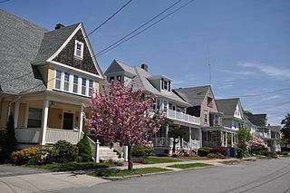
The Polk County Homestead and Trust Company Addition Historic District is a nationally recognized historic district located in Des Moines, Iowa, United States. It was listed on the National Register of Historic Places in 2016. At the time of its nomination the district consisted of 86 resources, including 48 contributing buildings, 11 contributing structures, 18 non-contributing buildings, and nine non-contributing structures. The end of the 19th-century saw the rise of the Victorian suburbs around Des Moines. This was a period of economic growth for the metropolitan area. The largest of these suburbs was North Des Moines. It was connected to Des Moines by way of three streetcar lines, whiched added to its attractiveness. Local real estate investors established the Polk County Homestead & Trust Co. to develop the northern portion of North Des Moines in partnership with the Prospect Park Improvement Company.

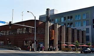
The Des Moines Fire Department Headquarters' Fire Station No. 1 and Shop Building are historic buildings located in downtown Des Moines, Iowa, United States. Completed in 1937, the facility provided a unified campus for the fire department's administration, citywide dispatch, training, maintenance, as well as the increased need for fire protective services in the commercial and warehouse districts in which the complex is located. It was designed by the Des Moines architectural firm of Proudfoot, Rawson, Brooks and Borg, and built by local contractor F.B. Dickinson & Co. The project provided jobs for local residents during the Great Depression, and 45% of its funding was provided by the Public Works Administration (PWA). The City of Des Moines provided the rest of the funds. The radio tower, which shares the historic designation with the building, was used to dispatch fire personnel from 1958 to 1978. The buildings were used by the local fire department from 1937 to 2013. It was replaced by two different facilities. The old fire station and shop building was acquired by the Des Moines Social Club, a nonprofit arts organization.


